
-
Federal
NAFD-ATT Forest Canopy Cover Loss from Landsat, CONUS, 1986-2010
National Aeronautics and Space Administration —
Characterizing the cause of forest canopy changes through time is fundamental to understanding current and future forest functions. A better understanding of forest... -
Federal
Net Radiation and Albedo from MODIS for Xingu River Basin, Brazil, 2000-2012 NGDA
National Aeronautics and Space Administration —
This dataset provides daily average land surface net radiation (Rnet) as an 8-day time series at approximately 0.5 km resolution for the upper Xingu River Basin in... -
Federal
LBA-ECO LC-14 Modeled Deforestation Scenarios, Amazon Basin: 2002-2050
National Aeronautics and Space Administration —
This data set provides the results of the two modeled scenarios for future patterns of deforestation across the Amazon Basin from 2002 to 2050. This larger defined... -
Federal
CMS: Mangrove Forest Cover Extent and Change across Major River Deltas, 2000-2016
National Aeronautics and Space Administration —
This dataset provides estimates of mangrove extent for 2016, and mangrove change (gain or loss) from 2000 to 2016, in major river delta regions of eight countries:... -
Federal
LBA-ECO LC-22 Post-deforestation Land Use, Mato Grosso, Brazil: 2001-2005 NGDA
National Aeronautics and Space Administration —
This data set provides (1) areal estimates of deforestation events (>25 ha) that were identified from 2001-2004 in Mato Grosso by the Brazilian Institute for Space... -
Federal
LBA-ECO LC-05 Biomass and Soil Properties of Fragmented Forests, Amazonas, Brazil
National Aeronautics and Space Administration —
This data set reports (1) total aboveground dry biomass based on detailed estimates of all live and dead plant material, (2) results from repeated surveys of... -
Federal
LBA-ECO CD-34 Landsat Fractional Land Cover Analysis, Manaus, Brazil: 2004-2005
National Aeronautics and Space Administration —
This data set provides the results of fractional land cover analysis for nonphotosynthetic vegetation (NPV) from two Landsat images of Manaus, Brazil, for October 14,... -
Federal
LBA-ECO LC-24 Landsat ETM+ Forest Cover Classification, Uruara, Para, Brazil: 1999
National Aeronautics and Space Administration —
This data set contains a 1999 Landsat ETM+ mosaic image land of cover classification showing forested and deforestation areas in Uruara, Para, Brazil. This image may... -
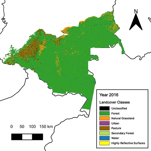
Federal
Aboveground Biomass, Landcover, and Degradation, Kalimantan Forests, Indonesia, 2014
National Aeronautics and Space Administration —
This dataset provides estimates of aboveground biomass, percent canopy cover, mean canopy height, landcover, and forest degradation index products for forests in... -
Federal
Woody and Herbaceous Vegetation Change across the Savannas of West Africa, 1982-2013
National Aeronautics and Space Administration —
The WAVeTrends dataset is a 0.05 degree (5.55 km) vegetation change product, spanning the West African Sudano-Sahel region. It provides pixel-wise information on... -
Federal
LBA-ECO LC-24 Historical Roads of the Legal Amazon: 1968-1993
National Aeronautics and Space Administration —
This data set contains ESRI shapefiles of historical roads (basin-wide federal and state roads) in nine Brazilian states for the Legal Amazon: Amazonas, Para, Acre,... -
Federal
LBA-ECO LC-24 Cadastral Property Map of Uruara, Para, Brazil: ca.1975
National Aeronautics and Space Administration —
This data set contains a shapefile of a digitized map of the land parcel information of the original properties of the Uruara colonization site, Para, Brazil,... -
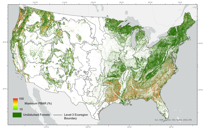
Federal
NACP NAFD Project: Forest Disturbance Intensity for CONUS from Landsat, 1986-2015
National Aeronautics and Space Administration —
This dataset contains estimates of forest disturbance intensity for the conterminous United States from 1986 to 2015. It quantifies the severity/intensity of forest... -
Federal
LBA-ECO CD-04 Logging Damage, km 83 Tower Site, Tapajos National Forest, Brazil
National Aeronautics and Space Administration —
This data set contains the results of a survey of logging damage in a 18 ha plot (300 m N-S, 600 m E-W) east (upwind) of the eddy flux tower at km 83, Tapajos... -
Federal
LBA-ECO LC-13 GIS Coverages of Logged Areas, Cauaxi, Para, Brazil: 1996, 1998
National Aeronautics and Space Administration —
This data set contains GIS coverage constructed from measurements taken of four logged areas in Cauaxi, Para, Brazil. Logged areas were selectively harvested either... -
Federal
LBA-ECO ND-11 Regeneration in Undisturbed and Logged Forests, NW Mato Grosso, Brazil
National Aeronautics and Space Administration —
This data set reports the results of field surveys to determine: regeneration diversity and size distribution of plants in primary undisturbed forest; and... -
Federal
LBA-ECO LC-13 GIS Coverages of Logged Areas, Tapajos Forest, Para, Brazil: 1996, 1998
National Aeronautics and Space Administration —
This data set contains GIS coverages constructed from measurements taken of logged areas in the Tapajos National Forest region of Para, Brazil in 1996 and 1998 (Asner... -
Federal
CMS: Estimated Deforested Area Biomass, Tropical America, Africa, and Asia, 2000
National Aeronautics and Space Administration —
This data set provides estimates of pre-deforestation aboveground live woody biomass (AGLB) at 30-m resolution for deforested areas of tropical America, tropical... -
Federal
CMS: Landsat-derived Annual Land Cover Maps for the Colombian Amazon, 2001-2016
National Aeronautics and Space Administration —
This dataset provides annual maps of land cover classes for the Colombian Amazon from 2001 through 2016 that were created by classifying time segments detected by the... -
Federal
LBA-ECO ND-04 Secondary Forest Carbon and Nutrient Stocks, Central Amazonia, Brazil
National Aeronautics and Space Administration —
This data set reports the carbon and nutrient stocks of above-ground vegetation and soil pools at three locations where post-pasture secondary forest recovery ranged...

Official websites use .gov
A
.gov website belongs to an official government
organization in the United States.
Secure .gov websites use HTTPS
A
lock (
) or https:// means you’ve safely connected to
the .gov website. Share sensitive information only on official,
secure websites.