
-
Federal
Phenology derived from Satellite Data and PhenoCam across CONUS and Alaska, 2019-2020
National Aeronautics and Space Administration —
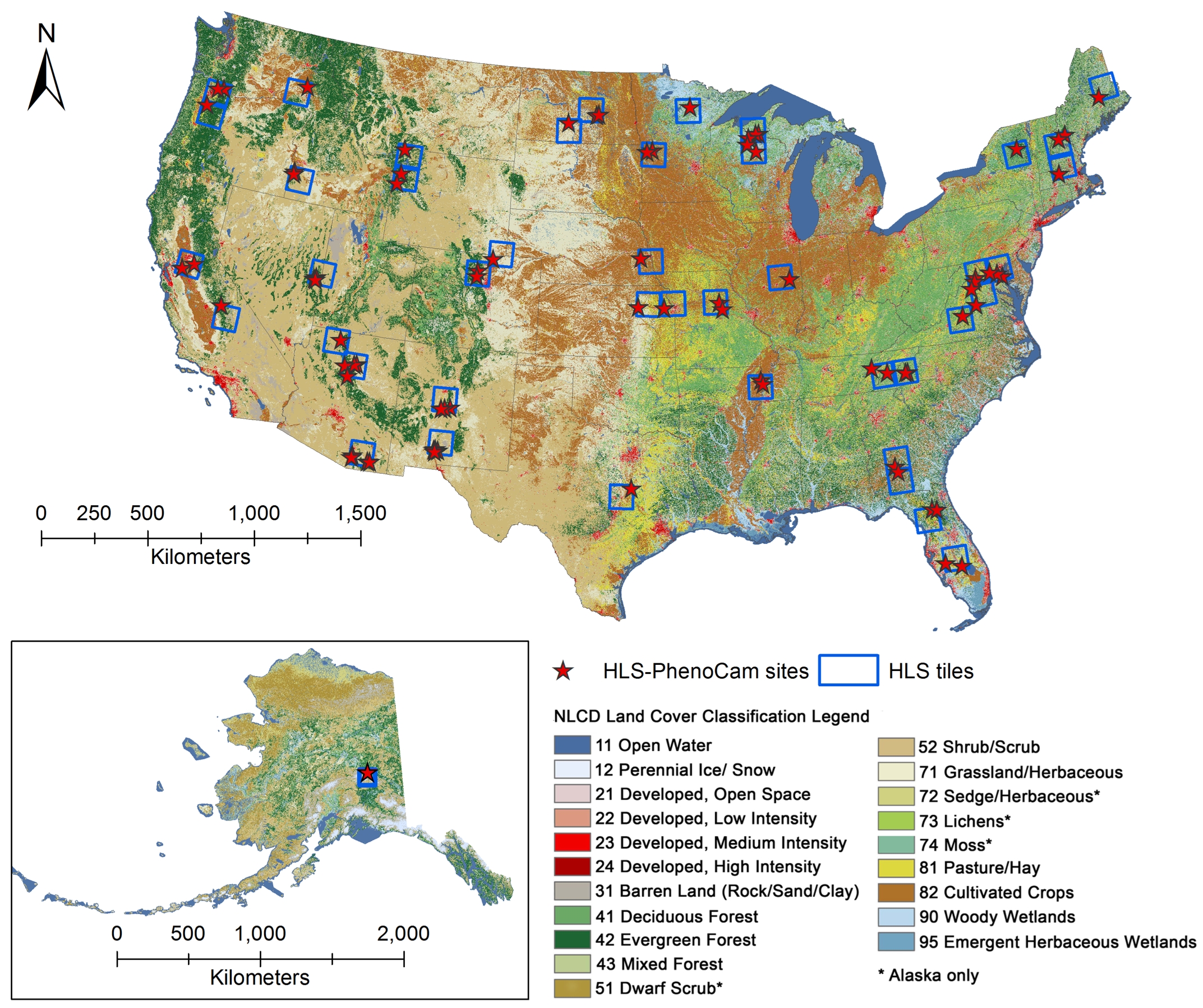
This dataset provides a reference of land surface phenology (LSP) at 30-m pixels for 78 regions of 10 x 10 km2 across a wide range of ecological and climatic regions... -
Federal
PalEON: Terrestrial Ecosystem Model Drivers for the Northeastern U.S., 0850-2010
National Aeronautics and Space Administration —
This dataset from the PalEON Ecosystem Model Intercomparison Project (PEMIP) provides harmonized regional environmental and meteorological drivers at a resolution of... -
Federal
CARVE: L1 In-situ Carbon and CH4 Flux and Meteorology at EC Towers, Alaska, 2011-2015
National Aeronautics and Space Administration —
This data set provides ground in situ flux and meteorological science data from fixed instruments at three eddy covariance tower sites located in the Alaskan Arctic... -
Federal
AirMOSS: L4 Modeled Volumetric Root Zone Soil Moisture, 2012-2015
National Aeronautics and Space Administration —
This data set provides hourly gridded soil moisture estimates derived from hydrologic modeling at nine AirMOSS sites across North America. The AirMOSS L4 RZSM product... -
Federal
ABoVE: Environmental Conditions and Subsistence Resource Access, Alaska, 2016-2017
National Aeronautics and Space Administration —
This dataset provides descriptions and photos of environmental conditions that impacted availability to subsistence resources by residents in nine rural communities... -
Federal
ISLSCP II Global Sea Ice Concentration
National Aeronautics and Space Administration —
This International Satellite Land Surface Climatology Project (ISLSCP) Initiative II data set, ISLSCP II Global Sea Ice Concentration, is based on the Goddard Space... -
Federal
SiB4 Modeled Global 0.5-Degree Hourly Carbon Fluxes and Productivity, 2000-2018
National Aeronautics and Space Administration —
This dataset provides global hourly output predicted from the Simple Biosphere Model, Version 4.2 (SiB4), at a 0.5-degree spatial resolution covering the time period... -
Federal
Alaska's Changing YK Delta: Knowledge Exchange between Elders and Geoscientists, 2018
National Aeronautics and Space Administration —
This dataset provides a booklet documenting the discussions and outcomes from a knowledge-exchange meeting with Yup'ik elders from the Yukon-Kuskokwim Delta (YKD),... -
Federal
ABoVE: Lake Growing Season Green Surface Reflectance Trends, AK and Canada, 1984-2019
National Aeronautics and Space Administration —
This dataset provides an annual time series of Landsat green surface reflectance and the derived annual trend during the growing season (June and July) for 472,890... -
Federal
ABoVE: Dall Sheep Lamb Recruitment and Climate Data, Alaska and NW Canada, 2000-2015 NGDA
National Aeronautics and Space Administration —
This dataset contains estimated annual average Dall sheep (Ovis dalli dalli) lamb-to-ewe ratios for each year from 2000-2015 across the full species range in Alaska... -
Federal
ABoVE: Last Day of Spring Snow, Alaska, USA, and Yukon Territory, Canada, 2000-2016 NGDA
National Aeronautics and Space Administration —
This dataset provides the last day of spring snow cover for most of Alaska and the Yukon Territory for 2000 through 2016. The data are based on the MODIS daily snow... -
Federal
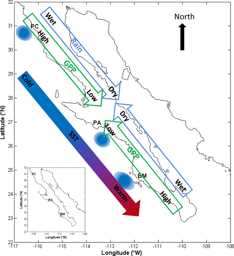
CMS: MODIS GPP, fPAR, and SST, and ENSO Index, Baja California, Mexico, 2000-2013 NGDA
National Aeronautics and Space Administration —
This data set provides data for MODIS-derived (1) gross primary productivity (GPP) for the years 2000-2010, (2) fraction of photosynthetically active radiation (fPAR)... -
Federal
ABoVE: Passive Microwave-derived Annual Snowoff Date Maps, 1988-2018
National Aeronautics and Space Administration —
This dataset provides annual maps of the snowoff (SO) date from 1988-2018 across Alaska and parts of Far East Russia and northwest Canada at a resolution of 6.25 km.... -
Federal
Arctic Vegetation Plots in Willow Communities, North Slope, Alaska, 1997
National Aeronautics and Space Administration —
This data set provides environmental, soil, and vegetation data collected in July and August 1997 from 85 study plots in willow shrub communities located along a... -
Federal
LBA-ECO LC-14 Root Biomass and Phenology, km 67 Site, Para, Brazil: 2001
National Aeronautics and Space Administration —
This data set contains biomass estimates for coarse roots measured on the forest floor and measurements of fine root growth down to 2-m depth at the km 67 Rainfall... -
Federal
CMS: Fire Weather Indices for Interior Alaska, 2001-2010
National Aeronautics and Space Administration —
This dataset provides daily fire weather indices for interior Alaska during the active fire seasons from 2001 to 2010. Data are gridded at 60-m resolution. The active... -
Federal
Pre-Delta-X: Water Levels across Wax Lake Outlet, Atchafalaya Basin, LA, USA, 2016
National Aeronautics and Space Administration —
This dataset provides absolute water level elevations derived for 10 locations across the Wax Lake Delta, Atchafalaya Basin, in Southern Louisiana, USA, within the... -
Federal
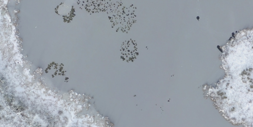
ABoVE: Aerial Photographs of Frozen Lakes near Fairbanks, Alaska, October 2014
National Aeronautics and Space Administration —
This dataset includes high resolution orthophotographs of 21 lakes in the region of Fairbanks, Alaska, USA. Aerial photographs were taken on October 8, 2014, three... -
Federal
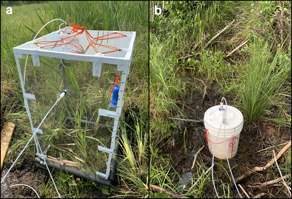
Methane Fluxes from Shorelines and Differing Surfaces, Big Trail Lake, Alaska, 2019
National Aeronautics and Space Administration —
This dataset provides methane fluxes from hot-spot and non-hot spot differing surfaces at Big Trail Lake (BTL) in the Goldstream Valley near Fairbanks, AK, USA.... -
Federal
ABoVE: Light-Curve Modelling of Gridded GPP Using MODIS MAIAC and Flux Tower Data NGDA
National Aeronautics and Space Administration —
This dataset contains gridded estimations of daily ecosystem Gross Primary Production (GPP) in grams of carbon per day at a 1 km2 spatial resolution over Alaska and...

Official websites use .gov
A
.gov website belongs to an official government
organization in the United States.
Secure .gov websites use HTTPS
A
lock (
) or https:// means you’ve safely connected to
the .gov website. Share sensitive information only on official,
secure websites.