SiB4 Modeled Global 0.5-Degree Hourly Carbon Fluxes and Productivity, 2000-2018
Access & Use Information
Downloads & Resources
-
Google Scholar search resultsHTML
Search results for publications that cite this dataset by its DOI.
-
Download this datasetHTML
This link allows direct data access via Earthdata login
-
View documentation related to this datasetHTML
ORNL DAAC Data Set Documentation
-
This dataset's landing pageHTML
Data set Landing Page DOI URL
-
Use OPeNDAP to access the dataset's dataHTML
USE SERVICE API
-
View documentation related to this datasetPDF
SiB4 Modeled Global 0.5-Degree Hourly Carbon Fluxes and Productivity,...
-
View documentation related to this datasetPDF
SiB4 Modeled Global 0.5-Degree Hourly Carbon Fluxes and Productivity,...
-
View documentation related to this datasetHTML
SiB4 Modeled Global 0.5-Degree Hourly Carbon Fluxes and Productivity,...
-
Get a related visualizationPNG
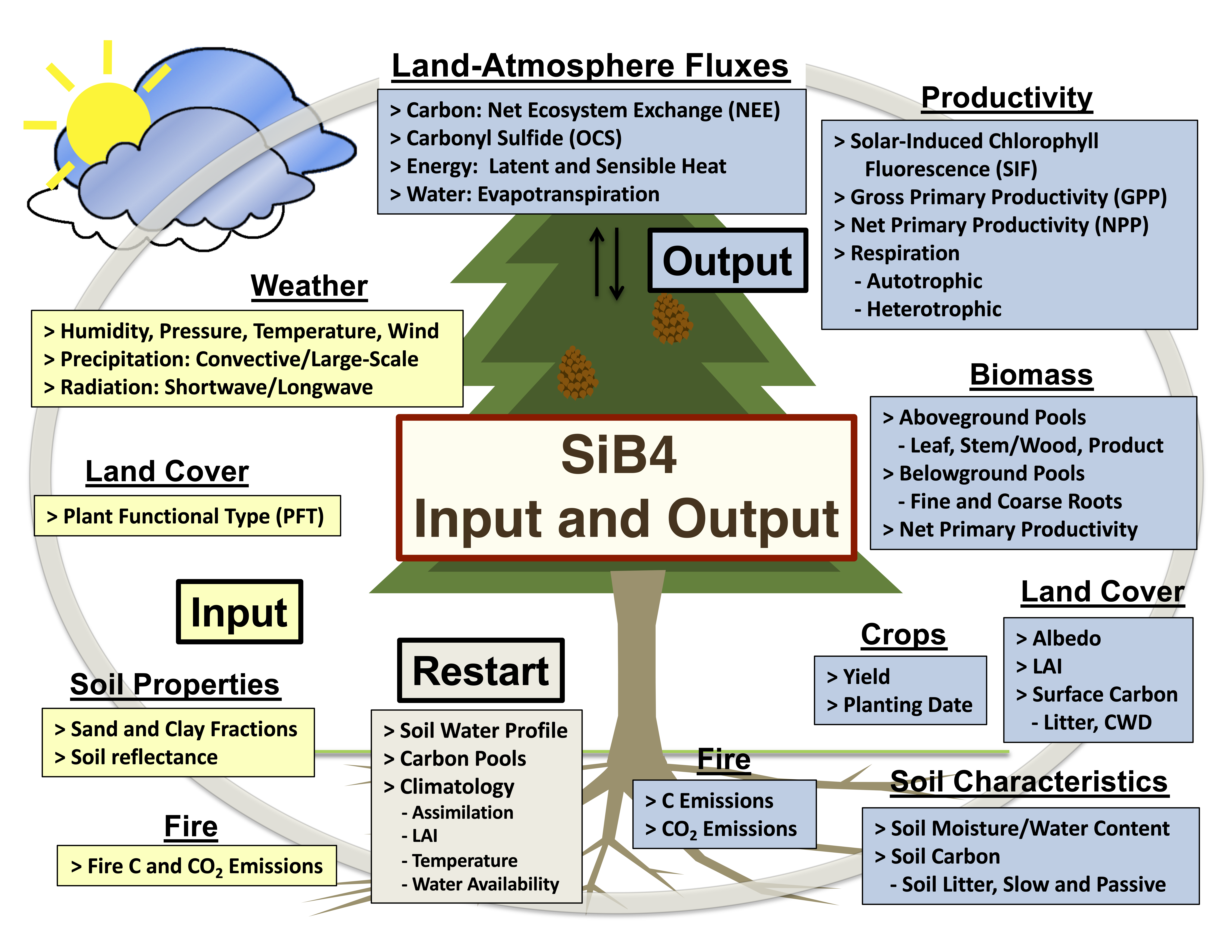
Overview of the Simple Biosphere Model (SiB4) that estimates carbon fluxes...
-
Landing PageLanding Page
Dates
| Metadata Created Date | December 1, 2022 |
|---|---|
| Metadata Updated Date | May 6, 2024 |
Metadata Source
- Data.json Data.json Metadata
Harvested from NASA Data.json
Graphic Preview

Additional Metadata
| Resource Type | Dataset |
|---|---|
| Metadata Created Date | December 1, 2022 |
| Metadata Updated Date | May 6, 2024 |
| Publisher | ORNL_DAAC |
| Maintainer | |
| Identifier | C2392085682-ORNL_CLOUD |
| Data First Published | 2024-05-01 |
| Language | en-US |
| Data Last Modified | 2024-05-02 |
| Category | CMS, geospatial |
| Public Access Level | public |
| Bureau Code | 026:00 |
| Metadata Context | https://project-open-data.cio.gov/v1.1/schema/catalog.jsonld |
| Metadata Catalog ID | https://data.nasa.gov/data.json |
| Schema Version | https://project-open-data.cio.gov/v1.1/schema |
| Catalog Describedby | https://project-open-data.cio.gov/v1.1/schema/catalog.json |
| Citation | Haynes, K.D., I.T. Baker, and A.S. Denning. 2021. SiB4 Modeled Global 0.5-Degree Hourly Carbon Fluxes and Productivity, 2000-2018. ORNL DAAC, Oak Ridge, Tennessee, USA. https://doi.org/10.3334/ORNLDAAC/1847 |
| Graphic Preview Description | Overview of the Simple Biosphere Model (SiB4) that estimates carbon fluxes among the atmosphere, vegetation, and soils. Input information is shown in yellow boxes. This dataset includes a selection of the output variables (blue boxes). Source: Haynes et al. (2020) |
| Graphic Preview File | https://daac.ornl.gov/CMS/guides/SiB4_Global_HalfDegree_Hourly_Fig1.png |
| Harvest Object Id | 41a06747-9088-4244-a0f7-7c2a6a7a5171 |
| Harvest Source Id | 58f92550-7a01-4f00-b1b2-8dc953bd598f |
| Harvest Source Title | NASA Data.json |
| Homepage URL | https://doi.org/10.3334/ORNLDAAC/1847 |
| Metadata Type | geospatial |
| Old Spatial | -180.0 -90.0 180.0 90.0 |
| Program Code | 026:001 |
| Source Datajson Identifier | True |
| Source Hash | ab306770ddf9f17d45dfa013d557d11b0f39e46d14a8f6fc7fe143264b1ba835 |
| Source Schema Version | 1.1 |
| Spatial | |
| Temporal | 2000-01-01T00:00:00Z/2018-12-31T23:59:59Z |
Didn't find what you're looking for? Suggest a dataset here.

