
-
Federal
A Global Database of Gas Fluxes from Soils after Rewetting or Thawing, Version 1.0
National Aeronautics and Space Administration —
This database contains information compiled from published studies on gas flux from soil following rewetting or thawing. The resulting database includes 222 field and... -
Federal
Northern and Mid-Latitude Soil Database, Version 1, R1
National Aeronautics and Space Administration —
The U.S. Department of Agriculture, Agriculture and Agri-Food Canada, the Russian Academy of Agricultural Sciences, the University of Copenhagen Institute of... -
Federal
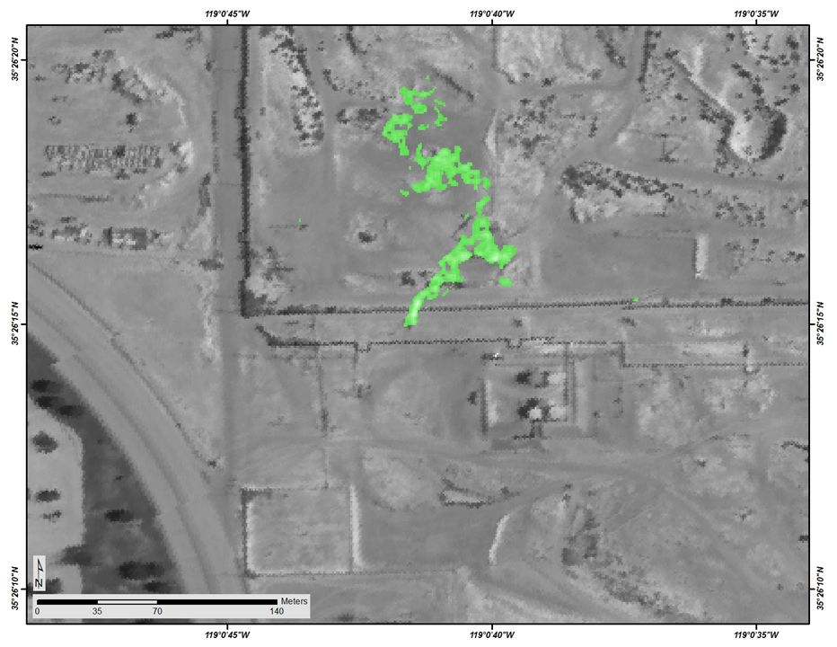
Methane Plumes Derived from AVIRIS-NG over Point Sources across California, 2016-2017
National Aeronautics and Space Administration —
This dataset provides maps of methane (CH4) plumes along flight lines over identified methane point-source emitting infrastructure across the State of California, USA... -
Federal
Longwave-infrared spectral imagery in support of COMEX, 2014
National Aeronautics and Space Administration —
This dataset provides calibrated at-sensor radiance, retrieved surface brightness temperature, and adaptive coherence estimator (ACE) detection imagery of methane,... -
Federal
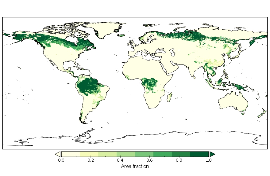
LUH2-GCB2019: Land-Use Harmonization 2 Update for the Global Carbon Budget, 850-2019
National Aeronautics and Space Administration —
This dataset, referred to as LUH2-GCB2019, includes 0.25-degree gridded, global maps of fractional land-use states, transitions, and management practices for the... -
Federal
Remote Sensing Data Before and After California Rim and King Forest Fires, 2010-2015
National Aeronautics and Space Administration —
This data set provides high-resolution surface reflectance, thermal imagery, burn severity metrics, and LiDAR-derived structural measures of forested areas in the... -
Federal
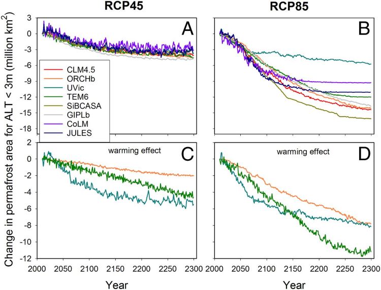
Projections of Permafrost Thaw and Carbon Release for RCP 4.5 and 8.5, 1901-2299
National Aeronautics and Space Administration —
This dataset consists of an ensemble of model projections from 1901 to 2299 for the northern hemisphere permafrost domain. The model projections include monthly... -
Federal
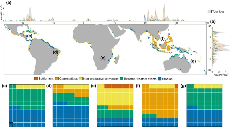
Global Mangrove Loss Extent, Land Cover Change, and Loss Drivers, 2000-2016
National Aeronautics and Space Administration —
This dataset provides estimates of the extent of mangrove loss, land cover change, and its anthropogenic or climatic drivers in three time periods: 2000-2005,... -
Federal
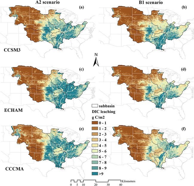
Export and Leaching of Carbon and Nitrogen from Mississippi River Basin, 1901-2099
National Aeronautics and Space Administration —
This dataset provides estimates for export and leaching of dissolved inorganic carbon (DIC), dissolved organic carbon (DIC), total organic carbon (TOC), particulate... -
Federal
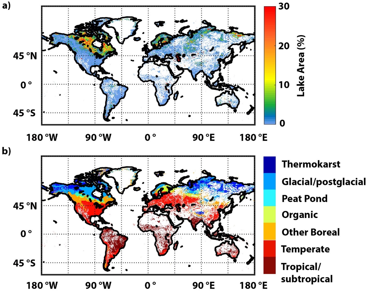
Global-Gridded Daily Methane Emissions Climatology from Lake Systems, 2003-2015
National Aeronautics and Space Administration —
This dataset provides global gridded information on lake surface area and open water CH4 emissions at a resolution of 0.25-degree x 0.25-degree for an annual... -
Federal
ABoVE: Wolf Denning Phenology and Reproductive Success, Alaska and Canada, 2000-2017
National Aeronautics and Space Administration —
This dataset provides annual gray wolf (Canis lupus) denning spatial information and timing, associated climatic and phenologic metrics, and reproductive success... -
Federal
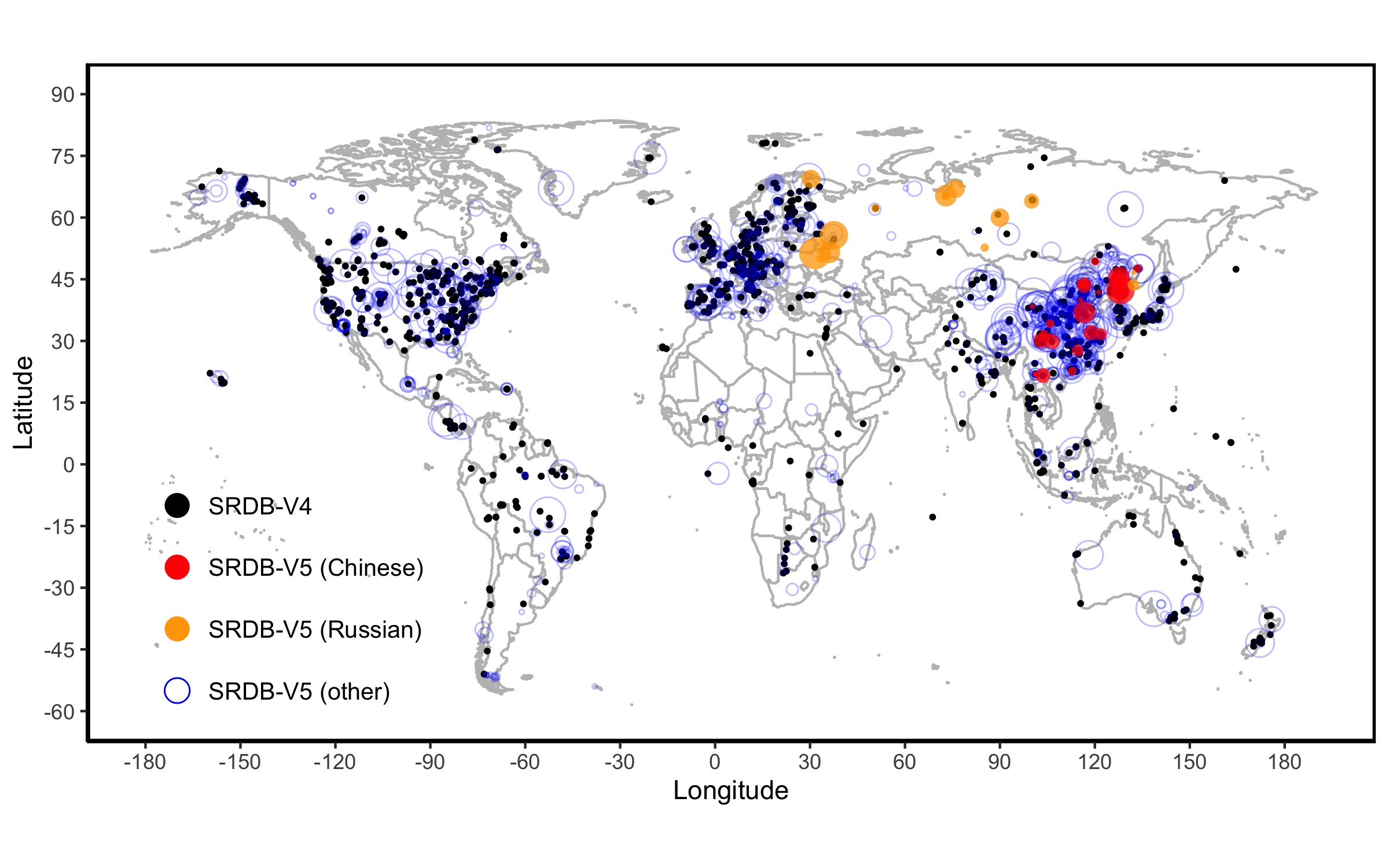
A Global Database of Soil Respiration Data, Version 5.0
National Aeronautics and Space Administration —
The Soil Respiration Database (SRDB) is a near-universal compendium of published soil respiration (Rs) data. The database encompasses published studies that report at... -
Federal
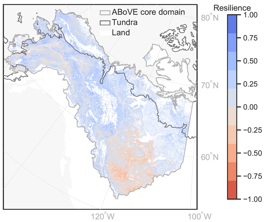
MODIS-derived Annual Vegetation Resilience, 2000-2019
National Aeronautics and Space Administration —
This dataset provides estimates of vegetation resilience in the Arctic Boreal Vulnerability Experiment (ABoVE) core domain at annual time steps for 2000-2019 and at... -
Federal
Methane Emissions from Dairy Sources (Vista-CA), State of California, USA, 2019
National Aeronautics and Space Administration —
This dataset provides estimates of methane (CH4) emissions from dairies in California at a resolution of 0.1 degrees (~ 10 km x 10 km) for the year 2019. The mapped... -
Federal
Remote Sensing Derived Topsoil and Agricultural Economic Losses, Midwestern USA
National Aeronautics and Space Administration —
This dataset provides estimates of topsoil loss and economic loss associated with decreased crop productivity resulting from topsoil loss at county- and state-levels... -
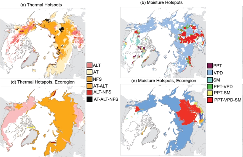
Federal
Trends of Thermal, Wetness, and Vegetative Change in the Circumpolar Arctic
National Aeronautics and Space Administration —
This dataset provides estimates of trends in temperature, moisture, and vegetation changes over the circumpolar Arctic. Time series trends were measured by the Theil-... -
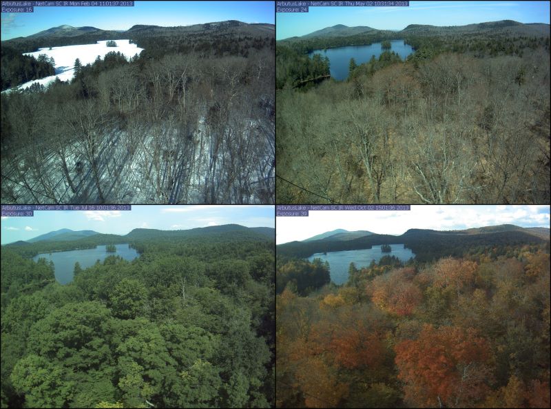
Federal
PhenoCam Dataset v3.0: Digital Camera Imagery from the PhenoCam Network, 2000-2023
National Aeronautics and Space Administration —
This dataset provides a time series of visible-wavelength digital camera imagery collected through the PhenoCam Network at each of 738 sites across diverse ecosystems... -
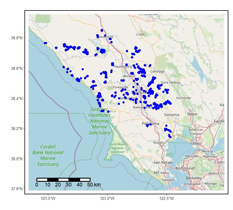
Federal
Soundscapes to Landscapes Acoustic Recordings, Sonoma County, CA, 2017-2022
National Aeronautics and Space Administration —
This dataset holds in situ sound recordings from sites in Sonoma County, California, USA as part of the Soundscapes to Landscapes citizen science project. Recordings... -
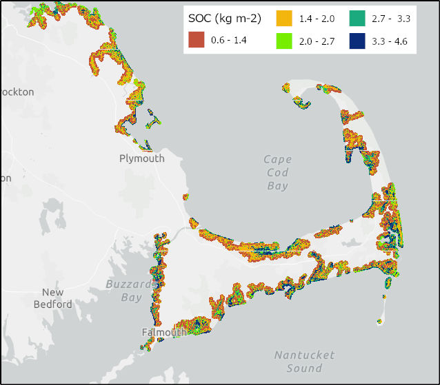
Federal
Soil Organic Carbon Distributions in Tidal Wetlands of the Northeastern USA
National Aeronautics and Space Administration —
This dataset provides estimates of soil organic carbon (SOC) in tidal wetlands for the northeastern United States. The data cover the period 1998-2018. Northeastern... -
Federal
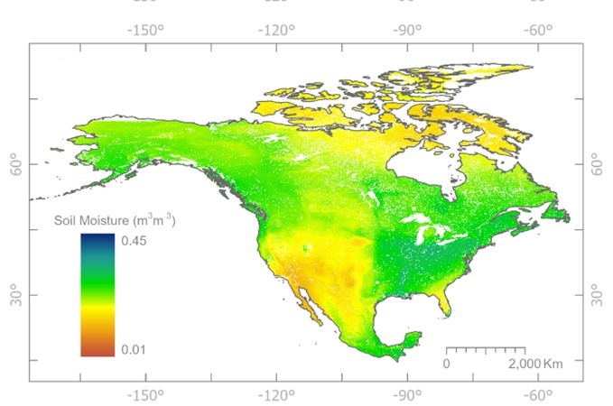
NASMo-TiAM 250m 16-day North America Surface Soil Moisture Dataset
National Aeronautics and Space Administration —
This NASMo-TiAM (North America Soil Moisture Dataset Derived from Time-Specific Adaptable Machine Learning Models) dataset holds gridded estimates of surface soil...

Official websites use .gov
A
.gov website belongs to an official government
organization in the United States.
Secure .gov websites use HTTPS
A
lock (
) or https:// means you’ve safely connected to
the .gov website. Share sensitive information only on official,
secure websites.