
-
Federal
Global Hydrologic Soil Groups (HYSOGs250m) for Curve Number-Based Runoff Modeling
National Aeronautics and Space Administration —
This dataset - HYSOGs250m - represents a globally consistent, gridded dataset of hydrologic soil groups (HSGs) with a geographical resolution of 1/480 decimal... -
Federal
AVIRIS-NG L2 Surface Reflectance, Facility Instrument Collection, V1
National Aeronautics and Space Administration —
This dataset contains Level 2 (L2) orthocorrected reflectance from the Airborne Visible / Infrared Imaging Spectrometer-Next Generation (AVIRIS-NG) instrument. This... -
Federal
Aircraft Flux-Detrended: Univ. Col. (FIFE)
National Aeronautics and Space Administration —
The NCAR King Air participation in FIFE-1987 and FIFE-1989 was part of a coordinated atmospheric boundary layer component which included other aircraft, surface... -
Federal
SAFARI 2000 Surface Atmospheric Radiative Transfer (SMART), Dry Season 2000
National Aeronautics and Space Administration —
Surface-sensing Measurements for Radiative Transfer (SMART) and Chemical, Optical, and Microphysical Measurements of In-situ Troposphere (COMMIT) consist of a suite... -
Federal
LBA-ECO LC-07 Wetland Extent, Vegetation, and Inundation: Lowland Amazon Basin
National Aeronautics and Space Administration —
This data set provides a map of wetland extent, vegetation type, and dual-season flooding state of the entire lowland Amazon basin. As described in Hess et al.... -
Federal
LBA-ECO LC-04 THMB Model Simulations for the Amazon and Tocantins Basins: 1939-1998
National Aeronautics and Space Administration —
The model output data provided were generated by the THMB 1.2 (Terrestrial Hydrology Model with Biogeochemistry) model which simulates the flow of water through... -
Federal
LBA Regional Derived Soil Properties, 0.5-Deg (ISRIC-WISE)
National Aeronautics and Space Administration —
The data set consists of a subset of the ISRIC-WISE global data set of derived soil properties for the study area of the Large Scale Biosphere-Atmosphere Experiment... -
Federal
LBA Regional Freshwater Wetlands, 1-Degree (Stillwell-Soller et al.)
National Aeronautics and Space Administration —
This data set consists of a subset of a 1-degree gridded global freshwater wetlands database (Stillwell-Soller et al. 1995). This subset was created for the study... -
Federal
Gridded GEDI Vegetation Structure Metrics and Biomass Density at Multiple Resolutions
National Aeronautics and Space Administration —
This dataset consists of near-global, analysis-ready, multi-resolution gridded vegetation structure metrics derived from NASA Global Ecosystem Dynamics Investigation... -
Federal
Global Forest Ecosystem Structure and Function Data For Carbon Balance Research
National Aeronautics and Space Administration —
A comprehensive global database has been assembled to quantify CO2 fluxes and pathways across different levels of integration (from photosynthesis up to net ecosystem... -
Federal
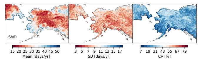
ABoVE: Passive Microwave-derived Annual Snow Melt Duration Date Maps, 1988-2018
National Aeronautics and Space Administration —
This dataset provides the annual period of snowpack melting (i.e., snow melt duration, SMD) across northwest Canada; Alaska, U.S.; and parts of far eastern Russia at... -
Federal
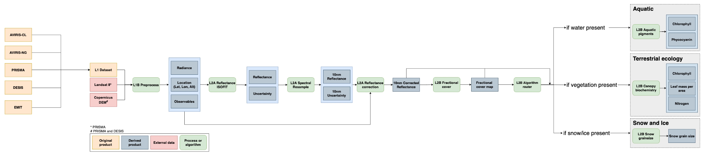
SISTER: Experimental Workflows, Product Generation Environment, and Sample Data, V004
National Aeronautics and Space Administration —
The Space-based Imaging Spectroscopy and Thermal pathfindER (SISTER) activity originated in support of the NASA Earth System Observatory's Surface Biology and Geology... -
Federal
SAFARI 2000 Wetlands Data Set, 1-Deg (Matthews and Fung)
National Aeronautics and Space Administration —
This database, compiled by Matthews and Fung (1987), provides information on the distribution and environmental characteristics of natural wetlands. The database was... -
Federal
Passive Microwave-derived Annual Snowoff Date Maps, 1988-2023
National Aeronautics and Space Administration —
This dataset provides annual maps of the snowoff (SO) date from 1988-2023 across Alaska and parts of Far East Russia and northwest Canada at a resolution of 6.25 km.... -
Federal
LBA-ECO CD-03 Flux-Meteorological Data, km 77 Pasture Site, Para, Brazil: 2000-2005
National Aeronautics and Space Administration —
Eddy correlation and micrometeorological measurements began in 2001 and continued through 2005 at the pasture site at km 77 on BR-163 just south of the city of... -
Federal
LBA Regional Wetlands Data Set, 1-Degree (Matthews and Fung)
National Aeronautics and Space Administration —
This database, compiled by Matthews and Fung (1987), provides information on the distribution and environmental characteristics of natural wetlands. The database was... -
Federal
VEMAP 2: Annual Ecosystem Model Responses to U.S. Climate Change, 1994-2100
National Aeronautics and Space Administration —
The Vegetation-Ecosystem Modeling and Analysis Project (VEMAP) was a large, collaborative, multi-institutional, international effort whose goal was to evaluate the... -
Federal
LBA Regional River Discharge Data (Coe and Olejniczak)
National Aeronautics and Space Administration —
This data set is a subset of a global river discharge data set by Coe and Olejniczak (1999). The subset was created for the study area of the Large Scale Biosphere-... -
Federal
LBA-ECO ND-06 Land Use Effects on Soil Nutrients: A Review of Studies 1950-2001
National Aeronautics and Space Administration —
This data set provides measurements of soil properties compiled from 39 studies on nutrient dynamics in natural forests and forest-derived land uses (pasture,... -
Federal
LBA-ECO LC-02 Tributary Coordinates, Acre River, Tri-national River Basin: 2003-2004
National Aeronautics and Space Administration —
This data set provides coordinates for points at the mouth of tributaries of the Acre River in the Tri-national River Basin in South America. Three Global Positioning...

Official websites use .gov
A
.gov website belongs to an official government
organization in the United States.
Secure .gov websites use HTTPS
A
lock (
) or https:// means you’ve safely connected to
the .gov website. Share sensitive information only on official,
secure websites.