
-
Federal
LBA-ECO CD-10 H2O Profiles at km 67 Tower Site, Tapajos National Forest
National Aeronautics and Space Administration —
This data set reports vertical profiles of H2O vapor concentrations measured at the Para Western (Santarem) - km 67, Primary Forest Tower Site (Figure 1). This site... -
Federal
BOREAS TE-09 Photosynthetic Response Data
National Aeronautics and Space Administration —
The BOREAS TE-09 team collected several data sets related to chemical and photosynthetic properties of leaves. This data set describes (1) the response of leaf and... -
Federal
Global Historical Climatology Network, 1753-1990
National Aeronautics and Space Administration —
This data set contains monthly temperature, precipitation, sea-level pressure, and station-pressure data for thousands of meteorological stations worldwide. The... -
Federal
Aircraft Flux-Detrended: Univ. Col. (FIFE)
National Aeronautics and Space Administration —
The NCAR King Air participation in FIFE-1987 and FIFE-1989 was part of a coordinated atmospheric boundary layer component which included other aircraft, surface... -
Federal
AMS (Automated Met Station) Data (FIFE)
National Aeronautics and Space Administration —
As part of the FIFE staff science data collection effort, the FIFE Information System (FIS) processed and archived 5 minute, near-surface radiometric and... -
Federal
LBA Regional Global Historical Climatology Network, V. 1, 1832-1990
National Aeronautics and Space Administration —
This data set consists of a subset of the Global Historical Climatology Network (GHCN) Version 1 database for the study area of the Large Scale Biosphere-Atmosphere... -
Federal
BOREAS/AES Campbell Scientific 15-minute Surface Meteorological Data: 1996
National Aeronautics and Space Administration —
Canadian AES personnel collected data related to surface and atmospheric meteorological conditions over the BOREAS Region. This data set contains 15 minute... -
Federal
ACT-America: Profile-based Planetary Boundary Layer Heights, Eastern USA
National Aeronautics and Space Administration —
This dataset provides profile-based estimates of the height to the top of the planetary boundary layer (PBL), also known as the atmospheric boundary layer (ABL), in... -
Federal
SAFARI 2000 Leaf-Level VOC Emissions, Maun, Botswana, Wet Season 2001
National Aeronautics and Space Administration —
Biogenic volatile organic compounds (VOCs) comprise a significant proportion of trace gases in the atmospheric environment and play an important role in the formation... -
Federal
ABoVE: Permafrost Measurements and Distribution Across the Y-K Delta, Alaska, 2016
National Aeronautics and Space Administration —
This dataset provides field observations of thaw depth and dominant vegetation types, a LiDAR-derived elevation map, and permafrost distribution and probability maps... -
Federal
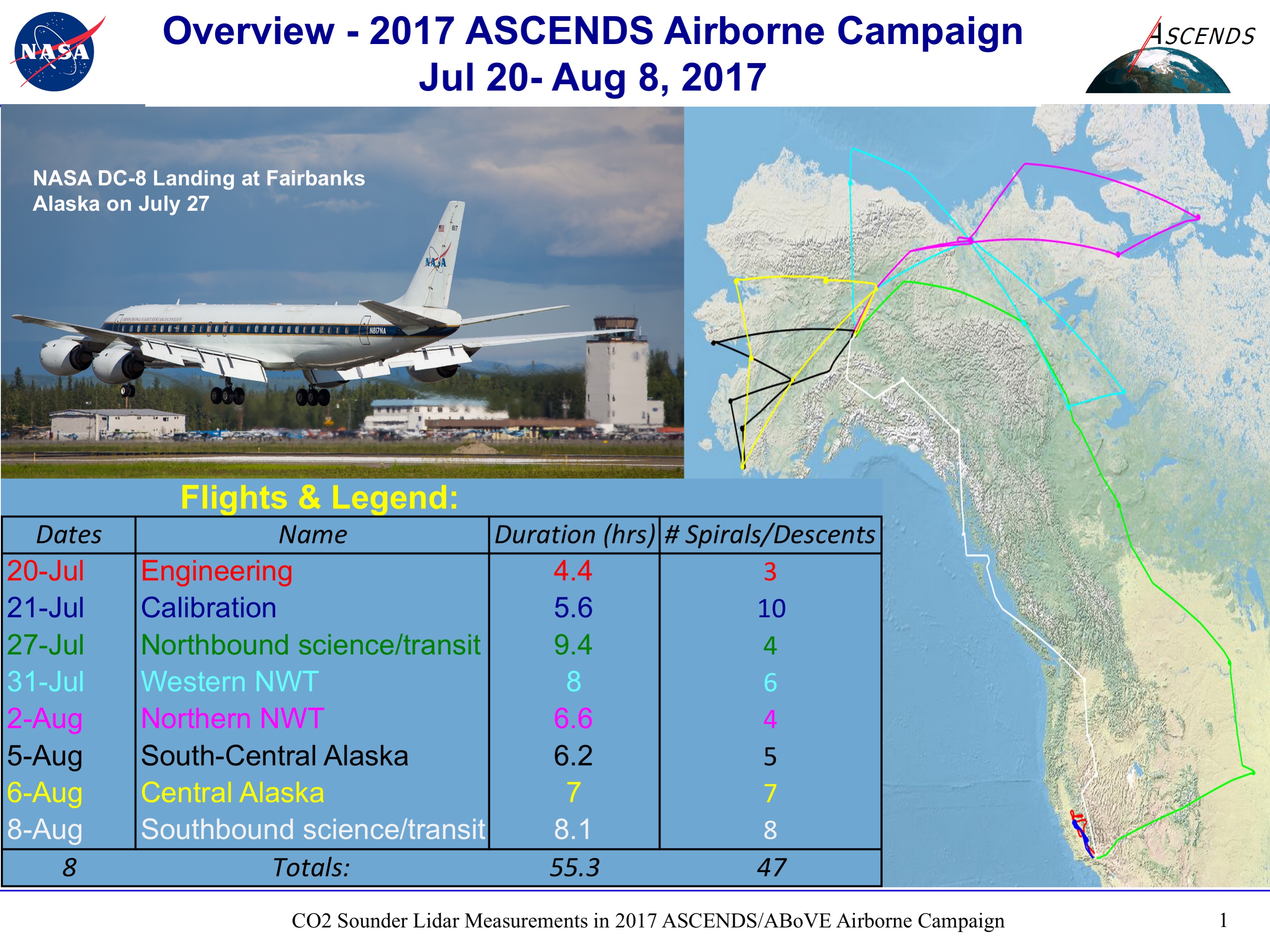
ABoVE/ASCENDS: Merged Atmospheric CO2, CH4, and Meteorological Data, 2017
National Aeronautics and Space Administration —
This dataset provides in situ airborne measurements of atmospheric carbon dioxide (CO2), methane (CH4), water vapor concentrations, air temperature, pressure, and... -
Federal
Aircraft Flux-Raw: Univ. Col. (FIFE)
National Aeronautics and Space Administration —
The NCAR King Air participation in FIFE-1987 and FIFE-1989 was part of a coordinated atmospheric boundary layer component which included other aircraft, surface... -
Federal
SAFARI 2000 Global Historical Climatology Network, V. 1, 1874-1990
National Aeronautics and Space Administration —
This data set consists of a southern African subset of the Global Historical Climatology Network (GHCN) Version 1 database. All stations with the following bounding... -
Federal
Atmos. Profile: Std. Press. Level (FIFE)
National Aeronautics and Space Administration —
The FIFE Standard Pressure Level Radiosonde Data Set provides a set of standard level profiles (i.e., 5 mb pressure intervals) from over 450 radiosonde balloon... -
Federal
BOREAS AFM-02 Wyoming King Air 1994 Aircraft Sounding Data
National Aeronautics and Space Administration —
The BOREAS AFM-02 team used the University of Wyoming King Air aircraft during IFCs 1, 2, and 3 in 1994 to collected pass-by-pass fluxes (and many other statistics)... -
Federal
BOREAS AFM-03 Electra 1994 Aircraft Flux and Moving Window Data
National Aeronautics and Space Administration —
The BOREAS AFM-03 team used the NCAR Electra aircraft data to make measurements of the fluxes of momentum, sensible and latent heat, carbon dioxide, and ozone over... -
Federal
SAFARI 2000 TOVS Surface and Atmospheric Parameters, 1-Deg, 1999-2001
National Aeronautics and Space Administration —
NOAA's TIROS (Television Infrared Observation Satellite) Operational Vertical Sounder (TOVS) is a suite of three sensors: the Microwave Sounding Unit (MSU), the High... -
Federal
BOREAS/AES Campbell Scientific 15-minute Surface Meteorological Data: 1995
National Aeronautics and Space Administration —
Canadian AES personnel collected data related to surface and atmospheric meteorological conditions over the BOREAS Region. This data set contains 15 minute... -
Federal
BOREAS AES Canadian Hourly and Daily Surface Meteorological Data, R1
National Aeronautics and Space Administration —
This data set contains hourly and daily meteorological data from 23 meteorological stations across Canada from January 1975 to January 1997. The surface meteorology... -
Federal
Atmos. Profile: Radiosonde - NCDC (FIFE)
National Aeronautics and Space Administration —
The NOAA Radiosonde Observations - 1989 (NCDC) Data Set contains radiosonde data obtained from the National Climatic Data Center (NCDC). These 396 days of data cover...

Official websites use .gov
A
.gov website belongs to an official government
organization in the United States.
Secure .gov websites use HTTPS
A
lock (
) or https:// means you’ve safely connected to
the .gov website. Share sensitive information only on official,
secure websites.