
-
Federal
Land Use and Cover Maps from Landsat, Mawas, Central Kalimantan, Indonesia, 1994-2019
National Aeronautics and Space Administration —
This dataset contains annual land use/cover (LUC) maps at 30 m resolution across Mawas, Central Kalimantan, Indonesia. There are six files, each representing a five-... -
Federal
Global Fire Atlas with Characteristics of Individual Fires, 2003-2016
National Aeronautics and Space Administration —
The Global Fire Atlas is a global dataset that tracks the day-to-day dynamics of individual fires to determine the timing and location of ignitions, fire size,... -
Federal
ABoVE: Thaw Depth at Selected Unburned and Burned Sites Across Alaska
National Aeronautics and Space Administration —
This dataset provides thaw depth measurements made at seven locations across Alaska, during August 2016, June and September 2017, and July-August 2018. Three of the... -
Federal
ABoVE: Boreal Forest Resilience Study 2020-2022, Fairbanks AK
National Aeronautics and Space Administration —
This dataset includes five metrics of forest resilience (recruitment, invasives, permafrost change, tree damage, and radial growth) at five recently burned forest... -
Federal
MASTER: California Fires, California, November 2007
National Aeronautics and Space Administration —
This dataset includes Level 1B (L1B) data products from the MODIS/ASTER Airborne Simulator (MASTER) instrument. The spectral data were collected during six flights... -
Federal
NACP Aboveground Biomass and Carbon Baseline Data, V.2 (NBCD 2000), U.S.A., 2000
National Aeronautics and Space Administration —
The NBCD 2000 (National Biomass and Carbon Dataset for the Year 2000) data set provides a high-resolution (30 m) map of year-2000 baseline estimates of basal area-... -
Federal
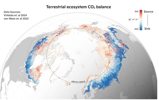
Machine learning-based Arctic-boreal terrestrial ecosystem CO2 fluxes, 2001-2020
National Aeronautics and Space Administration —
This dataset provides gridded estimates of gross primary productivity (GPP), ecosystem respiration (Reco), and net ecosystem CO2 exchange (NEE) across the circumpolar... -
Federal
LBA-ECO TG-10 Fire Emission Factors in Mato Grosso, Para, and Amazonas, Brazil: 2004
National Aeronautics and Space Administration —
This data set provides derived emission factors (EFs), reported in grams of compound emitted per kilogram of dry fuel (g/kg), for PM10 (particulate matter up to 10... -
Federal
LBA-ECO LC-04 IBIS Model Simulations for the Amazon and Tocantins Basins: 1921-1998
National Aeronautics and Space Administration —
The provided data were generated by the Integrated BIosphere Simulator (IBIS) terrestrial ecosystem model (Foley et al. 1996, Kucharik et al. 2000) using data from... -
Federal
ABoVE: Ignitions, Burned Area, and Emissions of Fires in AK, YT, and NWT, 2001-2018
National Aeronautics and Space Administration —
This dataset provides estimates of daily burned area, carbon emissions, and uncertainty, and daily fire ignition locations for boreal fires in Alaska, U.S., and in... -
Federal
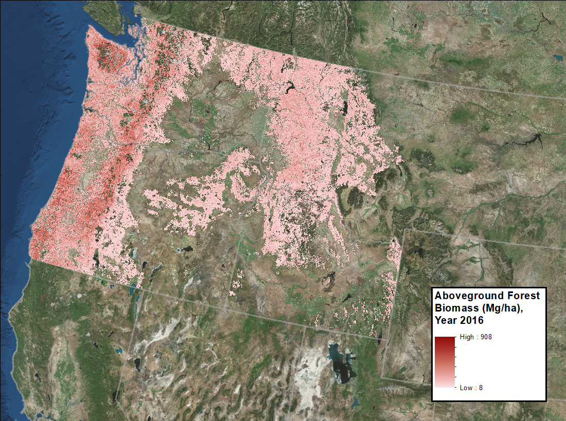
LiDAR Derived Forest Aboveground Biomass Maps, Northwestern USA, 2002-2016
National Aeronautics and Space Administration —
This dataset provides maps of aboveground forest biomass (AGB) of living trees and standing dead trees in Mg/ha across portions of Northwestern United States,... -
Federal
NACP Peatland Landcover Type and Wildfire Burn Severity Maps, Alberta, Canada
National Aeronautics and Space Administration —
This data set provides landcover maps of (1) peatland type (bog, fen, marsh, swamp) with levels of biomass (open, forested) and (2) Burn Severity Index (BSI) (Dyrness... -
Federal
LBA-ECO LC-02 GOES-08 Hot Pixel Data from Acre, Brazil: 1998, 2000, and 2001
National Aeronautics and Space Administration —
This data set provides hot pixel data, as an indicator of fires that were detected by the GOES-8 satellite for the state of Acre, Brazil. Image data were collected... -
Federal
Tree Mortality from Fires and Bark Beetles at 1-km Resolution, Western USA, 2003-2012
National Aeronautics and Space Administration —
This dataset provides annual estimates of tree mortality due to fires and bark beetles from 2003 to 2012 on forestland in the continental western United States. Tree... -
Federal
ABoVE: Active Layer Soil Characteristics at Selected Sites Across Alaska
National Aeronautics and Space Administration —
This dataset provides soil active layer characteristics from nine locations across Alaska. Soil samples were collected in 2016 except for one site which was sampled... -
Federal
ABoVE: Characterization of Carbon Dynamics in Burned Forest Plots, NWT, Canada, 2014
National Aeronautics and Space Administration —
This dataset provides field data from boreal forests in the Northwest Territories (NWT), Canada, that were burned by wildfires in 2014. During fieldwork in 2015, 211... -
Federal
Annual Aboveground Biomass Maps for Forests in the Northwestern USA, 2000-2016
National Aeronautics and Space Administration —
This dataset provides annual maps of aboveground biomass (AGB, Mg/ha) for forests in Washington, Oregon, Idaho, and western Montana, USA, for the years 2000-2016, at... -
Federal
Annual Burned Area from Landsat, Mawas, Central Kalimantan, Indonesia, 1997-2015
National Aeronautics and Space Administration —
This dataset provides maps of annual burned area for the part of Mawas conservation program in Central Kalimantan, Indonesia from 1997 through 2015. Landsat imagery... -
Federal
Distribution of Estimated Stand Age Across Siberian Larch Forests, 1989-2012
National Aeronautics and Space Administration —
This data set provides mapped estimates of the stand age of young (less than 25 years old) larch forests across Siberia from 1989-2012 at 30-m resolution. The age...

Official websites use .gov
A
.gov website belongs to an official government
organization in the United States.
Secure .gov websites use HTTPS
A
lock (
) or https:// means you’ve safely connected to
the .gov website. Share sensitive information only on official,
secure websites.