
-
Federal
ATom: In Situ Data from Caltech Chemical Ionization Mass Spectrometer (CIT-CIMS), V2
National Aeronautics and Space Administration —
This dataset provides the concentrations of gas-phase organic and inorganic analytes measured by the California Institute of Technology (CIT) Chemical Ionization Mass... -
Federal
Ground-based Observations of XCO2, XCH4, and XCO, Fairbanks, AK, 2016-2019
National Aeronautics and Space Administration —
This dataset provides ground-based column-averaged dry mole fractions (DMFs) of CO2 (xco2), CO (xco), CH4 (xch4), and N2O (xn2o) to supplement satellite-based... -
Federal
LiDAR-based Biomass Estimates, Boreal Forest Biome, Eurasia, 2005-2006
National Aeronautics and Space Administration —
This data set provides estimates of aboveground biomass (AGB) for defined land cover types within World Wildlife Fund (WWF) ecoregions across the boreal biome of... -
Federal
LBA-ECO LC-13 GIS Coverages of Logged Areas, Cauaxi, Para, Brazil: 1996, 1998
National Aeronautics and Space Administration —
We combined a detailed field study of canopy gap fraction with spectral mixture analysis of Landsat ETM+ satellite imagery to assess landscape and regional dynamics... -
Federal
LBA-ECO LC-13 GIS Coverages of Logged Areas, Tapajos Forest, Para, Brazil: 1996, 1998
National Aeronautics and Space Administration —
We combined a detailed field study of canopy gap fraction with spectral mixture analysis of Landsat ETM+ satellite imagery to assess landscape and regional dynamics... -
Federal
SAFARI 2000 ALI/ETM+ Tandem Image Pair for Skukuza, South Africa, May 2001
National Aeronautics and Space Administration —
A tandem pair of Advanced Land Imager (ALI) and Landsat Enhanced Thematic Mapper Plus (ETM+) scenes covering the same part of Kruger National Park (KNP), South Africa... -
Federal
TransCom 3: Annual Mean CO2 Flux Estimates from Atmospheric Inversions (Level 1)
National Aeronautics and Space Administration —
The Atmospheric Tracer Transport Model Intercomparison Project (TransCom) was created to quantify and diagnose the uncertainty in inversion calculations of the global... -
Federal
Delta-X: AVIRIS-NG L3 Derived Herbaceous Aboveground Biomass, MRD, Louisiana, USA, V3
National Aeronautics and Space Administration —
This dataset includes high-resolution (~5 m) gridded estimates of aboveground biomass (AGB), aboveground necromass (AGN), and aboveground net primary productivity... -
Federal
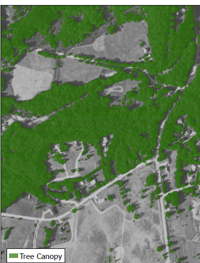
CMS: Tree Canopy Cover at 0.5-meter resolution, Vermont, 2016
National Aeronautics and Space Administration —
This dataset contains estimates of tree canopy cover presence at high resolution (0.5m) across the state of Vermont for 2016 in Cloud-Optimized GeoTIFF (*.tif)... -
Federal
LBA Regional Land Cover from AVHRR, 8-km, 1984 (DeFries et al.)
National Aeronautics and Space Administration —
This data set is a subset of an 8-km global land cover product (DeFries et al. 1998). This subset was created for the study area of the Large Scale Biosphere-... -
Federal
LBA-ECO LC-09 Soil Composition and Structure in the Brazilian Amazon: 1992-1995
National Aeronautics and Space Administration —
This data set reports basic soil structure and composition information for five Amazonian research sites: Altamira, Bragantina, Tome-Acu, and Ponta de Pedras, all... -
Federal
BOREAS Follow-On DSP-01 Landsat TM Land Cover Mosaic of the BOREAS Transect
National Aeronautics and Space Administration —
The objective of this land cover mosaic is to provide a data product that characterises the detailed land cover of a significant portion of the BOREAS Region. Seven... -
Federal
SAFARI 2000 1-Degree Estimates of Burned Biomass, Area, and Emissions, 2000
National Aeronautics and Space Administration —
A new method is used to generate spatial estimates of monthly averaged biomass burned area and spatial and temporal estimates of trace gas and aerosol emissions from... -
Federal
SAFARI 2000 Land Cover from AVHRR, 8-km, 1984 (DeFries et al.)
National Aeronautics and Space Administration —
This data set consists of a southern African subset of the University of Maryland (UMD) 8-km Global Land Cover product in ASCII GRID and binary image files formats.... -
Federal
LBA Regional Land Cover from AVHRR, 1-km, 1992-1993 (Hansen et al.)
National Aeronautics and Space Administration —
This data set is a subset of Hansen et al. (1999), "1 km Global Land Cover Data Set Derived from AVHRR," which was developed at the Laboratory for Global Remote... -
Federal
LBA-ECO LC-13 GIS Coverages of Logged Areas, Juruena, Mato Grosso, Brazil: 2002
National Aeronautics and Space Administration —
We combined a detailed field study of canopy gap fraction with spectral mixture analysis of Landsat ETM+ satellite imagery to assess landscape and regional dynamics... -
Federal
SAFARI 2000 Land Cover from AVHRR, 1-km, 1992-1993 (Hansen et al.)
National Aeronautics and Space Administration —
The data set consists of a southern African subset of the 1-km Global Land Cover Data Set Derived from AVHRR developed at the Laboratory for Global Remote Sensing... -
Federal
Satellite Atmos. Correction Coef. (FIFE)
National Aeronautics and Space Administration —
The atmospheric effects on the transmitted and reflected solar radiation should be factored into the estimation of geophysical and biophysical parameters from... -
Federal
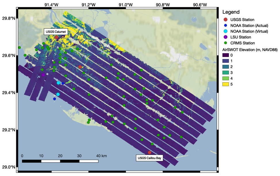
Pre-Delta-X: L2 AirSWOT Water Surface Elevations, Atchafalaya Basin, LA, USA, 2016
National Aeronautics and Space Administration —
This dataset provides water surface elevations over the Wax Lake Delta in the Atchafalaya Basin in coastal Louisiana, USA, in May 2015. These Level 2 (L2) data were...

Official websites use .gov
A
.gov website belongs to an official government
organization in the United States.
Secure .gov websites use HTTPS
A
lock (
) or https:// means you’ve safely connected to
the .gov website. Share sensitive information only on official,
secure websites.