

14 datasets found for "84p직장인디비문의l(텔레darknessDB§"
-
Federal
NACP Site: Terrestrial Biosphere Model Output Data in Original Format
National Aeronautics and Space Administration —
This data set contains the original model output data submissions from the 24 terrestrial biosphere models (TBM) that participated in the North American Carbon... -
Federal
Forest Inventory and Biophysical Measurements, Brazilian Amazon, 2009-2018
National Aeronautics and Space Administration —
This dataset provides the complete catalog of forest inventory and biophysical measurements collected over selected forest research sites across the Amazon rainforest... -
Federal
NACP MCI: CO2 Flux from Inversion Modeling, Upper Midwest Region, USA, 2007
National Aeronautics and Space Administration —
This data set provides estimates of Net Ecosystem Exchange (NEE) flux for the U.S. Upper Midwest at 0.5-degree resolution for the year 2007. Estimates were produced... -
Federal
NACP Site: Terrestrial Biosphere Model and Aggregated Flux Data in Standard Format
National Aeronautics and Space Administration —
This data set provides standardized output variables for gross primary productivity (GPP), net ecosystem exchange (NEE), leaf area index (LAI), ecosystem respiration... -
Federal
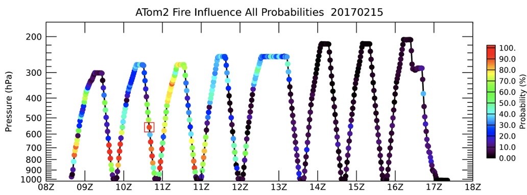
ATom: Back Trajectories and Influences of Air Parcels Along Flight Track, 2016-2018
National Aeronautics and Space Administration —
This dataset contains back trajectories, boundary layer influences, and convective influences of air parcels along NASA DC-8 aircraft's flight tracks during the four... -
Federal
ABoVE: Riverbank Erosion and Vegetation Changes, Yukon River Basin, Alaska, 1984-2017
National Aeronautics and Space Administration —
This dataset provides a time series of riverbank erosion and vegetation colonization along reaches of the Yukon River (3 study areas), Tanana and Nenana Rivers (1... -
Federal
LBA-ECO LC-02 Biophysical Measurements of Forests, Acre, Brazil: 1999-2002
National Aeronautics and Space Administration —
This data set provides diameter at breast height (DBH) measurements for 1,063 trees located at the Catuaba Experimental Farm, and 812 trees located in the Humaita... -
Federal
Soil Organic Carbon Stock Estimates with Uncertainty across Latin America
National Aeronautics and Space Administration —
This dataset provides 5 x 5 km gridded estimates of soil organic carbon (SOC) across Latin America that were derived from existing point soil characterization data... -
Federal
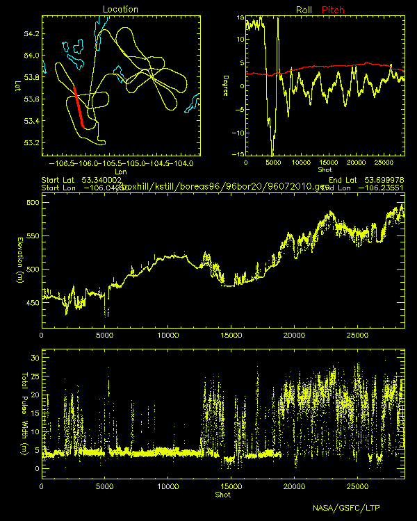
BOREAS Scanning Lidar Imager of Canopies by Echo Recovery (SLICER): Level-3 Data
National Aeronautics and Space Administration —
Scanning Lidar Imager of Canopies by Echo Recovery (SLICER) data were acquired in support of BOReal Ecosystem-Atmosphere Study (BOREAS) at all of the Tower Flux (TF)... -
Federal
ATom: CAM-chem/CESM2 Model Outputs Along Flight Tracks, 2016-2018
National Aeronautics and Space Administration —
This dataset contains CAM-chem (Community Atmosphere Model with Chemistry) model outputs along ATom flight tracks. CAM-chem is a component of the Community Earth... -
Federal
A Compilation of Global Soil Microbial Biomass Carbon, Nitrogen, and Phosphorus Data
National Aeronautics and Space Administration —
This data set provides the concentrations of soil microbial biomass carbon (C), nitrogen (N) and phosphorus (P), soil organic carbon, total nitrogen, and total... -
Federal
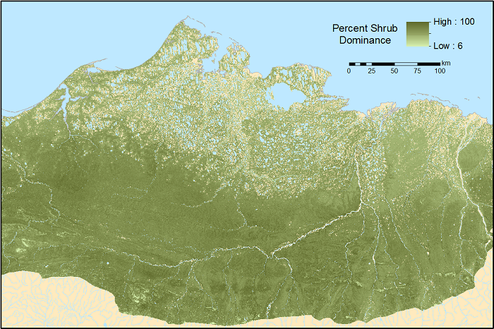
ABoVE: Gridded 30-m Aboveground Biomass, Shrub Dominance, North Slope, AK, 2007-2016
National Aeronautics and Space Administration —
This dataset includes 30-m gridded estimates of total plant aboveground biomass (AGB), the shrub AGB, and the shrub dominance (shrub/plant AGB) for non-water portions... -
Federal
ABoVE: CO2 and CH4 Fluxes and Meteorology at Flux Tower Sites, Alaska, 2015-2017
National Aeronautics and Space Administration —
This dataset provides CO2 and CH4 fluxes and meteorological parameters from five eddy covariance (EC) tower sites located at Barrow (three sites), Atqasuk (ATQ) and... -
Federal
SAFARI 2000 Modeled Tropospheric Air Mass Trajectories, Dry Season 2000
National Aeronautics and Space Administration —
The ETA Forecast Trajectory Model was used to produce forecasts of air-parcel trajectories twice a day at three pressure levels over seven sites in Southern Africa...
14 datasets found for "84p직장인디비문의l(텔레darknessDB§"