
-
Federal
Land Use and Cover Maps from Landsat, Mawas, Central Kalimantan, Indonesia, 1994-2019
National Aeronautics and Space Administration —
This dataset contains annual land use/cover (LUC) maps at 30 m resolution across Mawas, Central Kalimantan, Indonesia. There are six files, each representing a five-... -
Federal
Gridded GEDI Vegetation Structure Metrics and Biomass Density at Multiple Resolutions
National Aeronautics and Space Administration —
This dataset consists of near-global, analysis-ready, multi-resolution gridded vegetation structure metrics derived from NASA Global Ecosystem Dynamics Investigation... -
Federal
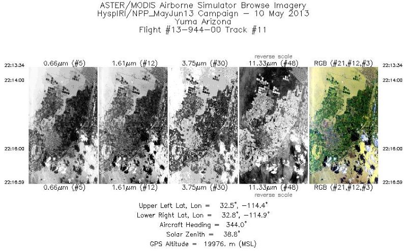
MASTER: Suomi-NPP Airborne Campaign, 2013
National Aeronautics and Space Administration —
This dataset includes Level 1B (L1B) and Level 2 (L2) data products from the MODIS/ASTER Airborne Simulator (MASTER) instrument. The spectral data were collected for... -
Federal
Snow Properties and Wildlife Tracks in Washington and Alaska
National Aeronautics and Space Administration —
This dataset contains three field seasons of snow-wildlife observations conducted at 707 sites from January 2021 to March 2023 in Washington and Alaska, spanning a... -
Federal
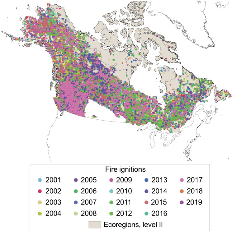
ABoVE: Ignitions of ABoVE-FED Fires in Alaska and Canada
National Aeronautics and Space Administration —
This dataset provides daily fire ignition locations and timing for boreal fires in Alaska, U.S., and Canada between 2001 and 2019. The fire ignition locations and... -
Federal
ABoVE: Wolf Denning Phenology and Reproductive Success, Alaska and Canada, 2000-2017
National Aeronautics and Space Administration —
This dataset provides annual gray wolf (Canis lupus) denning spatial information and timing, associated climatic and phenologic metrics, and reproductive success... -
Federal
ATom: Measurements of Soluble Acidic Gases and Aerosols (SAGA)
National Aeronautics and Space Administration —
Soluble acidic gases and aerosols (SAGA) were collected with two related installations; a mist chamber/ion chromatography (MC/IC) system and a paired bulk aerosol... -
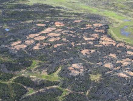
Federal
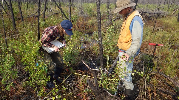
ABoVE: Post-Fire and Unburned Vegetation Community and Field Data, NWT, Canada, 2018
National Aeronautics and Space Administration —
This dataset provides vegetation community characteristics and biophysical data collected in 2018 from areas that were burned by wildfire in 2014 and 2015, and from... -
Federal
Resilience of Coastal Wetlands to Sea Level Rise, CONUS, 1996-2100
National Aeronautics and Space Administration —
This dataset provides information about the resilience of tidal wetlands to sea-level rise under three scenarios of global change. With rising seas, regularly... -
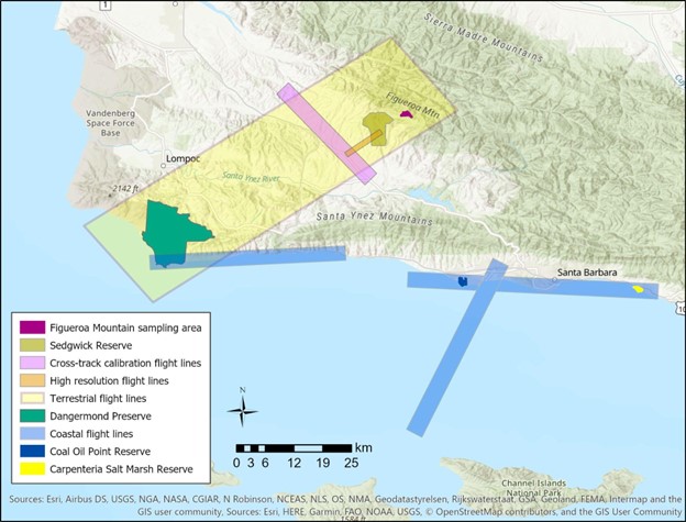
Federal
SHIFT: Vegetation Plot Characterization, Santa Barbara County, CA, 2022
National Aeronautics and Space Administration —
This dataset contains vegetation plot locations, descriptions, fractional cover, and sample identifier information from surveys conducted as part of the 2022 NASA... -
Federal
Global Mangrove Loss Extent, Land Cover Change, and Loss Drivers, 2000-2016
National Aeronautics and Space Administration —
This dataset provides estimates of the extent of mangrove loss, land cover change, and its anthropogenic or climatic drivers in three time periods: 2000-2005,... -
Federal
SAFARI 2000 MODIS Airborne Simulator Data, Southern Africa, Dry Season 2000
National Aeronautics and Space Administration —
This dataset contains the Moderate Resolution Imaging Spectroradiometer (MODIS) Airborne Simulator (MAS) multispectral data collected during the SAFARI 2000 project.... -
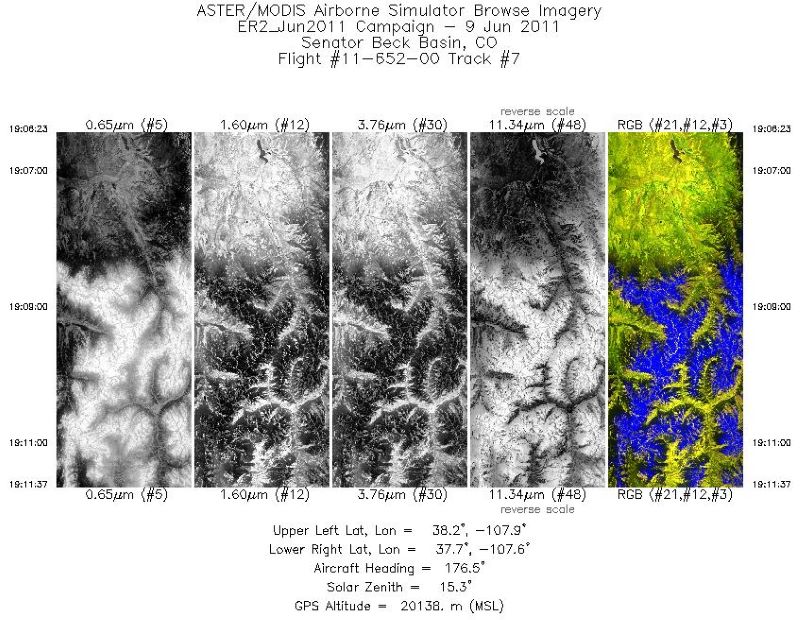
Federal
MASTER: Airborne Science, Southwest US, June, 2011
National Aeronautics and Space Administration —
This dataset includes Level 1B (L1B) and Level 2 (L2) data products from the MODIS/ASTER Airborne Simulator (MASTER) instrument. The spectral data were collected... -
Federal
MASTER: Airborne Science, California-Nevada-Arizona, May, 1999
National Aeronautics and Space Administration —
This dataset includes Level 1B (L1B) data products from the MODIS/ASTER Airborne Simulator (MASTER) instrument. The spectral data were collected during a single... -
Federal
ABoVE: Post-Fire and Unburned Field Site Data, Anaktuvuk River Fire Area, 2008-2017
National Aeronautics and Space Administration —
This dataset includes field measurements from 26 burned and unburned transects established in 2008 in the region of the Anaktuvuk River tundra fire on the Arctic... -
Federal
Delta-X: Delft3D Sediment Model, Site 421, Terrebonne Basin, MRD, Louisiana, USA
National Aeronautics and Space Administration —
This dataset contains the Delft3D model of the intensive site 421 in the Terrebonne Basin along the Mississippi River Delta (MRD) in coastal Louisiana. Simulations... -
Federal
AVIRIS-3 L1B Calibrated Radiance, Facility Instrument Collection
National Aeronautics and Space Administration —
This dataset contains Level 1B (L1B) calibrated radiance images as well as observational geometry and illumination parameters from the Airborne Visible / Infrared... -
Federal
BOREAS Follow-On DSP-01 Landsat TM Land Cover Mosaic of the BOREAS Transect
National Aeronautics and Space Administration —
The objective of this land cover mosaic is to provide a data product that characterises the detailed land cover of a significant portion of the BOREAS Region. Seven... -
Federal
MASTER: BP Oil Spill Mapping, Louisiana-Gulf of Mexico-Wisconsin, Fall, 2010
National Aeronautics and Space Administration —
This dataset includes Level 1B (L1B) and Level 2 (L2) data products from the MODIS/ASTER Airborne Simulator (MASTER) instrument. The raw data were collected during 9... -
Federal
AVIRIS-3 L2B Greenhouse Gas Enhancements, Facility Instrument Collection
National Aeronautics and Space Administration —
This dataset contains Level 2B (L2b) enhancements of greenhouse gasses (GHG) derived from imagery collected by the Airborne Visible / Infrared Imaging Spectrometer-3...

Official websites use .gov
A
.gov website belongs to an official government
organization in the United States.
Secure .gov websites use HTTPS
A
lock (
) or https:// means you’ve safely connected to
the .gov website. Share sensitive information only on official,
secure websites.