
-
Federal
Global Hydrologic Soil Groups (HYSOGs250m) for Curve Number-Based Runoff Modeling
National Aeronautics and Space Administration —
This dataset - HYSOGs250m - represents a globally consistent, gridded dataset of hydrologic soil groups (HSGs) with a geographical resolution of 1/480 decimal... -
Federal
ABoVE: Thaw Depth at Selected Unburned and Burned Sites Across Alaska
National Aeronautics and Space Administration —
This dataset provides thaw depth measurements made at seven locations across Alaska, during August 2016, June and September 2017, and July-August 2018. Three of the... -
Federal
Anthropogenic Carbon Emission System, 2012-2017, Version 2
National Aeronautics and Space Administration —
This dataset provides estimates of hourly carbon dioxide (CO2) emissions from the combustion of fossil fuels at 1-km resolution for the coterminous United States... -
Federal
ABoVE: Boreal Forest Resilience Study 2020-2022, Fairbanks AK
National Aeronautics and Space Administration —
This dataset includes five metrics of forest resilience (recruitment, invasives, permafrost change, tree damage, and radial growth) at five recently burned forest... -
Federal
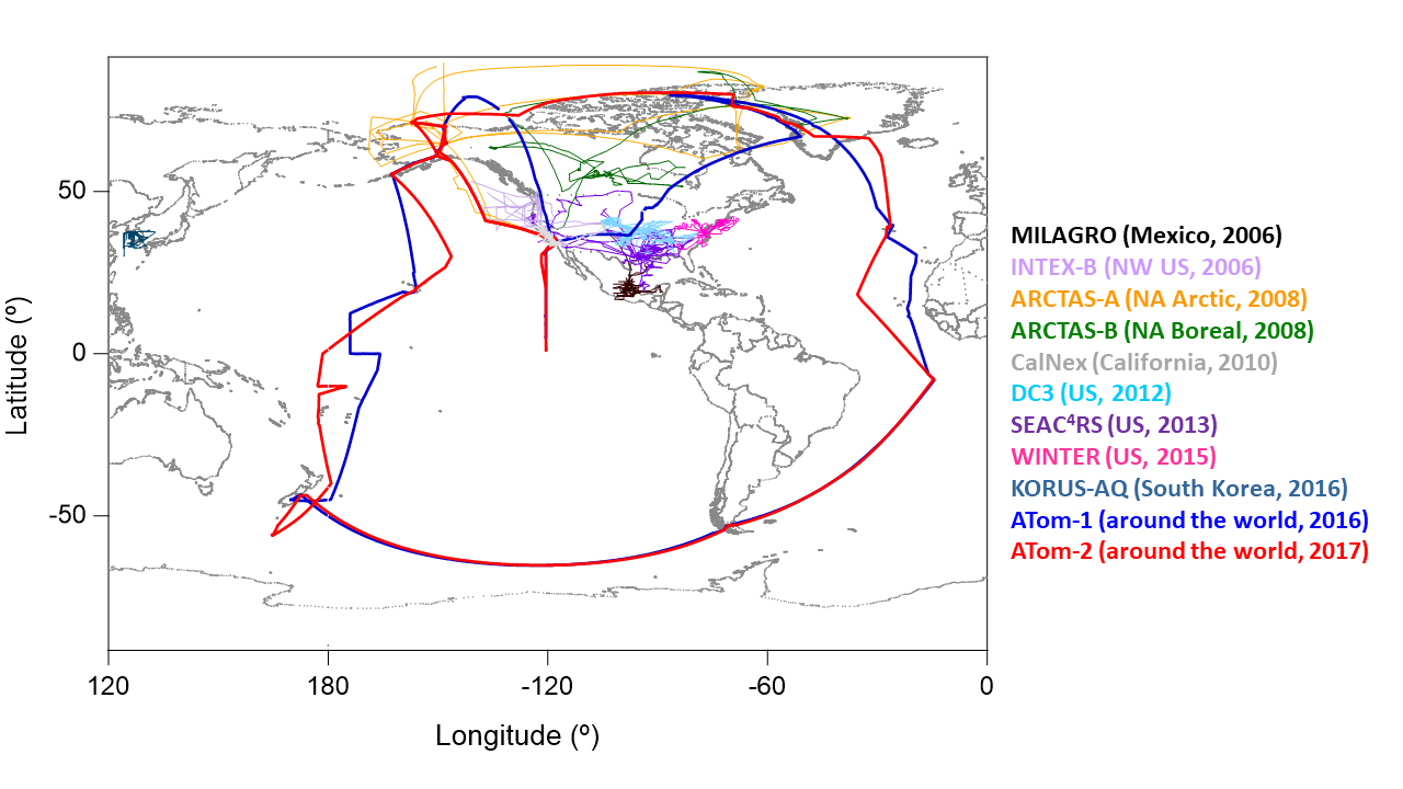
Airborne Observations and Modeling Comparison of Global Inorganic Aerosol Acidity
National Aeronautics and Space Administration —
This dataset provides observations collected during eleven airborne campaigns from 2006–2017 and associated input and output from nine widely used chemical transport... -
Federal
Ground-based Observations of XCO2, XCH4, and XCO, Fairbanks, AK, 2016-2019
National Aeronautics and Space Administration —
This dataset provides ground-based column-averaged dry mole fractions (DMFs) of CO2 (xco2), CO (xco), CH4 (xch4), and N2O (xn2o) to supplement satellite-based... -
Federal
Hourly Soil Moisture Logger Data, Alberta and Alaska, 2017-2021
National Aeronautics and Space Administration —
This dataset includes hourly in-situ soil moisture measurements from data loggers in predominantly organic soils (very low bulk density) at two locations: 1) along... -
Federal
ABoVE: CO2 and CH4 Fluxes and Meteorology at Flux Tower Sites, Alaska, 2015-2017
National Aeronautics and Space Administration —
This dataset provides CO2 and CH4 fluxes and meteorological parameters from five eddy covariance (EC) tower sites located at Barrow (three sites), Atqasuk (ATQ) and... -
Federal
ABoVE: Needle-Level Chlorophyll Fluorescence, Alaska and Idaho, USA, 2017 and 2019
National Aeronautics and Space Administration —
This dataset provides the results of in situ measurements of needle-level chlorophyll fluorescence (ChlF) obtained from a pulse amplitude modulated (PAM) fluorometer... -
Federal
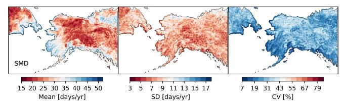
ABoVE: Passive Microwave-derived Annual Snow Melt Duration Date Maps, 1988-2018
National Aeronautics and Space Administration —
This dataset provides the annual period of snowpack melting (i.e., snow melt duration, SMD) across northwest Canada; Alaska, U.S.; and parts of far eastern Russia at... -
Federal
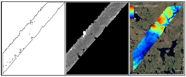
ABoVE: AirSWOT Ka-band Radar over Surface Waters of Alaska and Canada, 2017
National Aeronautics and Space Administration —
This dataset provides AirSWOT (Surface Water and Ocean Topography) Ka-band (35.75 GHz) radar data products collected from an airborne platform over parts of Alaska... -
Federal
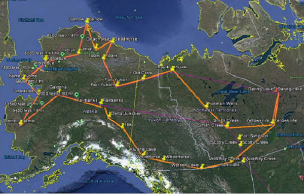
ABoVE: Atmospheric Gas Concentrations from Airborne Flasks, Arctic-CAP, 2017
National Aeronautics and Space Administration —
This dataset provides atmospheric carbon dioxide (CO2), methane (CH4), carbon monoxide (CO), molecular hydrogen (H2), nitrous oxide (N2O), sulfur hexafluoride (SF6),... -
Federal
ABoVE: White Spruce Photosynthetic and Leaf Traits, Alaska and New York, 2017
National Aeronautics and Space Administration —
This dataset provides measurements of gas exchange (light response curves, Kok curves and ACi curves), leaf traits (carbon, nitrogen, and specific leaf area), leaf... -
Federal
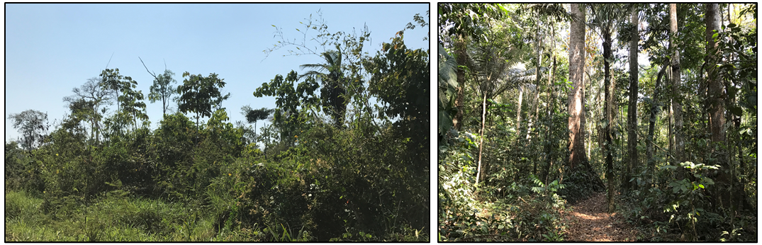
Forest Inventories and DBH at Burned and Unburned Forest Sites, Acre, Brazil, 2017
National Aeronautics and Space Administration —
This data set provides measurements of diameter at breast height (DBH) and species identification at four forest sites in the eastern side of Acre, Brazil including... -
Federal
Sources of Methane Emissions (Vista-LA), South Coast Air Basin, California, USA
National Aeronautics and Space Administration —
This data set provides spatial data products with identified and classified locations of potential methane (CH4) emitting facilities and infrastructure in the South... -
Federal
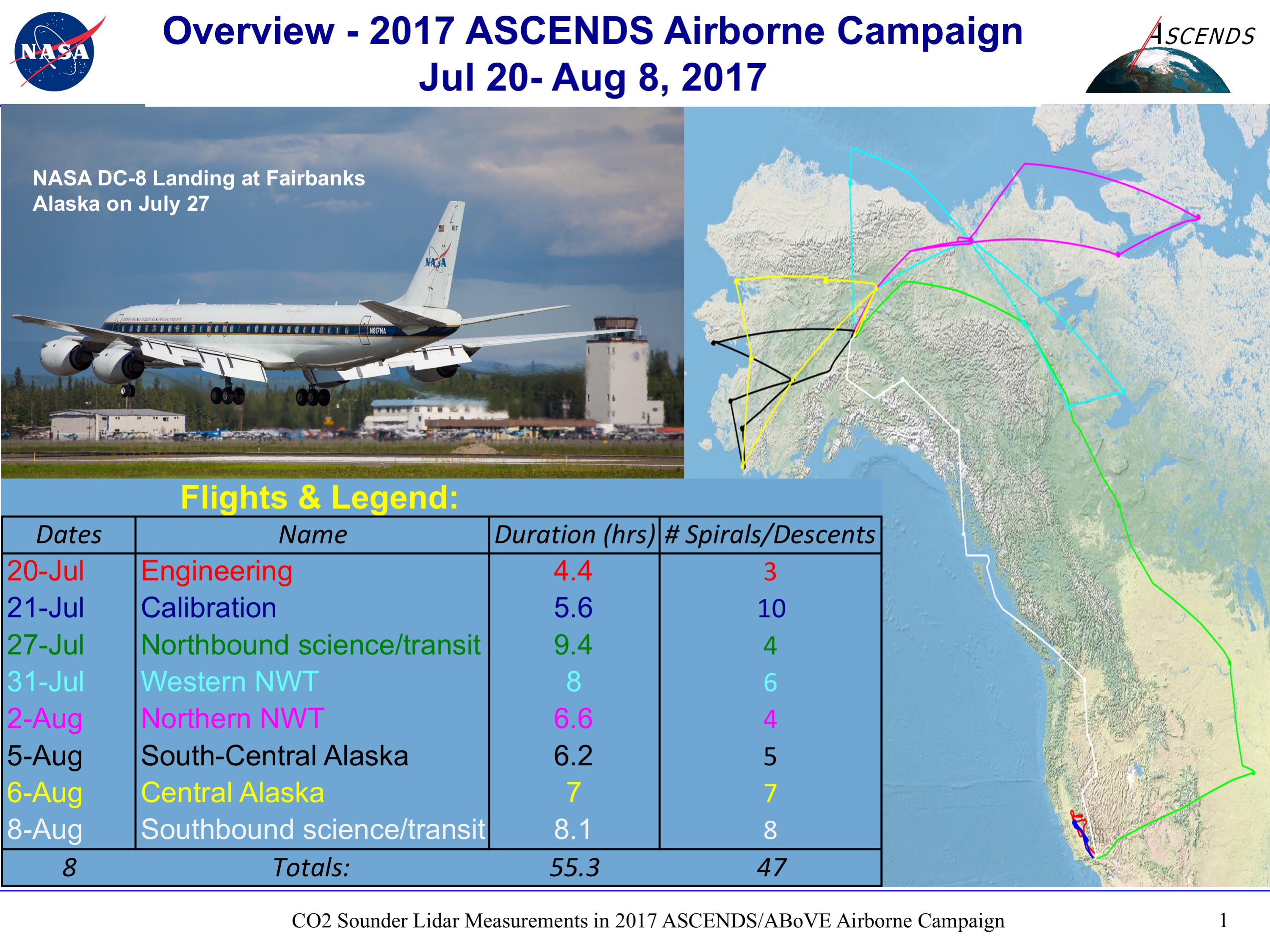
ABoVE/ASCENDS: Active Sensing of CO2, CH4, and Water Vapor, Alaska and Canada, 2017
National Aeronautics and Space Administration —
This dataset provides in situ airborne measurements of atmospheric carbon dioxide (CO2), methane (CH4), and water vapor concentrations, plus air temperature,... -
Federal
ABoVE: Wetland Type, Slave River and Peace-Athabasca Deltas, Canada, 2007 and 2017
National Aeronautics and Space Administration —
This dataset provides ecosystem-types for the Slave River Delta (SRD) and Peace-Athabasca Delta (PAD), Canada, for the time periods circa 2007 and circa 2017. The... -
Federal
CMS: Simulated Physical-Biogeochemical Data, SABGOM Model, Gulf of Mexico, 2005-2010
National Aeronautics and Space Administration —
This dataset contains monthly mean ocean surface physical and biogeochemical data for the Gulf of Mexico simulated by the South Atlantic Bight and Gulf of Mexico... -
Federal
SBG 2024 TIM Meeting Summary: Current Progress and Future Goals of the SBG Mission
National Aeronautics and Space Administration —
This report summarizes the community discussions at the 2024 NASA Surface Biology and Geology (SBG) Technical Interchange Meeting (TIM) from May 29 to 31, 2024, in... -
Federal
ACT-America: L2 In Situ Atmospheric CO2, CO, CH4, and O3 Concentrations, Eastern USA
National Aeronautics and Space Administration —
This dataset provides atmospheric carbon dioxide (CO2), carbon monoxide (CO), methane (CH4), water vapor (H2O), and ozone (O3) concentrations collected during...

Official websites use .gov
A
.gov website belongs to an official government
organization in the United States.
Secure .gov websites use HTTPS
A
lock (
) or https:// means you’ve safely connected to
the .gov website. Share sensitive information only on official,
secure websites.