
-
Federal
NASA-SSH Global Mean Sea Level from Simple Gridded Sea Surface Height
National Aeronautics and Space Administration —
This file contains a time series of globally-averaged sea level change, or "global mean sea level" (GMSL) in units of centimeters. The estimate is based on satellite... -
Federal
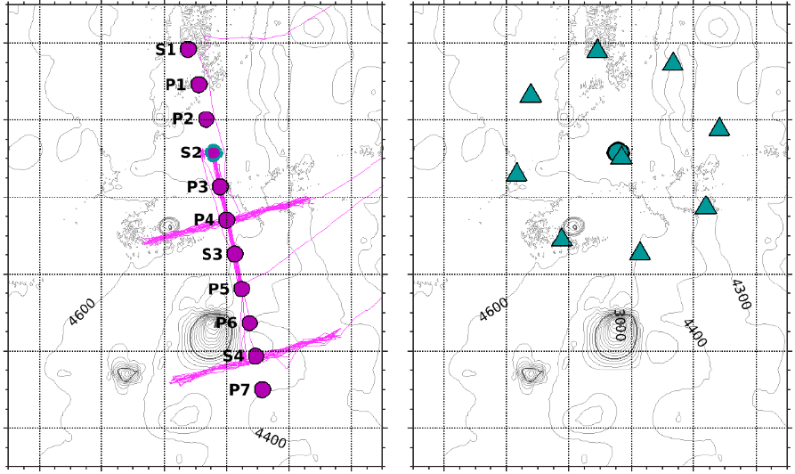
OMG Narwhals oceanographic data from moorings, 2018-2020
National Aeronautics and Space Administration —
This OMG Narwhals L3 dataset contains daily-averaged temperature and salinity measurements from CTD and temperature loggers from the same mooring. NASA’s Oceans... -
Federal
Sentinel-6A MF Jason-CS L2 Advanced Microwave Radiometer (AMR-C) STC Geophysical Parameters
National Aeronautics and Space Administration —
Provides L2 short time critical (STC; 36-hour latency) geophysical information from the Advanced Microwave Radiometer on the Sentinel-6A Michael Freilich spacecraft... -
Federal
NASA-SSH Along-Track Sea Surface Height from Standardized Reference Missions Version 1
National Aeronautics and Space Administration —
The NASA-SSH Along-Track Sea Surface Height from Standardized Reference Missions Version 1 dataset produced by NASA provide observations of sea surface height, or sea... -
Federal
Harmonic Constants for Baroclinic Tide Prediction
National Aeronautics and Space Administration —
This dataset of Harmonic Constants for Baroclinic Tide Prediction was produced by Edward Zaron (Oregon State University) and Shane Elipot (University of Miami). It... -
Federal
NASA-SSH Simple Gridded Sea Surface Height from Standardized Reference Missions Only Version 1
National Aeronautics and Space Administration —
The NASA-SSH Simple Gridded Sea Surface Height from Standardized Reference Missions Only Version 1 dataset produced by NASA provides 2-D maps of sea surface height,... -
Federal
NASA-SSH ENSO Sea Surface Height Indicator
National Aeronautics and Space Administration —
This file contains an indicator for the El Nino-Southern Oscillation (ENSO), based on satellite observations of sea surface height anomaly, measured by radar... -
Federal
ECCO Sea-Ice and Snow Concentration and Thickness - Daily Mean llc90 Grid (Version 4 Release 4)
National Aeronautics and Space Administration —
This dataset provides daily-averaged sea-ice and snow concentration, thickness, and pressure loading on the native Lat-Lon-Cap 90 (LLC90) model grid from the ECCO... -
Federal
ECCO Sea-Ice and Snow Concentration and Thickness - Monthly Mean llc90 Grid (Version 4 Release 4)
National Aeronautics and Space Administration —
This dataset provides monthly-averaged sea-ice and snow concentration, thickness, and pressure loading on the native Lat-Lon-Cap 90 (LLC90) model grid from the ECCO... -
Federal
ECCO Ocean and Sea-Ice Surface Stress - Daily Mean llc90 Grid (Version 4 Release 4)
National Aeronautics and Space Administration —
This dataset provides daily-averaged ocean and sea-ice surface stress on the native Lat-Lon-Cap 90 (LLC90) model grid from the ECCO Version 4 Release 4 (V4r4) ocean... -
Federal
ECCO Ocean Three-Dimensional Potential Temperature Fluxes - Daily Mean llc90 Grid (Version 4 Release 4)
National Aeronautics and Space Administration —
This dataset provides daily-averaged ocean three-dimensional potential temperature fluxes on the native Lat-Lon-Cap 90 (LLC90) model grid from the ECCO Version 4... -
Federal
ECCO Ocean and Sea-Ice Surface Heat Fluxes - Monthly Mean 0.5 Degree (Version 4 Release 4)
National Aeronautics and Space Administration —
This dataset contains monthly-averaged ocean and sea-ice surface heat fluxes interpolated to a regular 0.5-degree grid from the ECCO Version 4 revision 4 (V4r4) ocean... -
Federal
ECCO Sea-Ice Salt Plume Fluxes - Daily Mean llc90 Grid (Version 4 Release 4)
National Aeronautics and Space Administration —
This dataset provides daily-averaged sea-ice salt plume fluxes on the native Lat-Lon-Cap 90 (LLC90) model grid from the ECCO Version 4 Release 4 (V4r4) ocean and sea-... -
Federal
ECCO Sea-Ice and Snow Concentration and Thickness - Snapshot llc90 Grid (Version 4 Release 4)
National Aeronautics and Space Administration —
This dataset provides instantaneous sea-ice and snow concentration, thickness, and pressure loading on the native Lat-Lon-Cap 90 (LLC90) model grid from the ECCO... -
Federal
ECCO Ocean Mixed Layer Depth - Daily Mean 0.5 Degree (Version 4 Release 4)
National Aeronautics and Space Administration —
This dataset contains daily-averaged ocean mixed layer depth interpolated to a regular 0.5-degree grid from the ECCO Version 4 revision 4 (V4r4) ocean and sea-ice... -
Federal
ECCO Ocean Bottom Pressure - Monthly Mean 0.5 Degree (Version 4 Release 4)
National Aeronautics and Space Administration —
This dataset contains monthly-averaged ocean bottom pressure interpolated to a regular 0.5-degree grid from the ECCO Version 4 revision 4 (V4r4) ocean and sea-ice... -
Federal
Rongowai-CYGNSS Airborne Level 1 Science Data Record Version 1.0
National Aeronautics and Space Administration —
The Rongowai Level 1 Science Data Record Version 1.0 dataset is generated by the University of Auckland (UoA) Rongowai Science Payloads Operations Centre in New... -
Federal
ECCO Ocean Mixed Layer Depth - Monthly Mean 0.5 Degree (Version 4 Release 4)
National Aeronautics and Space Administration —
This dataset contains monthly-averaged ocean mixed layer depth interpolated to a regular 0.5-degree grid from the ECCO Version 4 revision 4 (V4r4) ocean and sea-ice...

Official websites use .gov
A
.gov website belongs to an official government
organization in the United States.
Secure .gov websites use HTTPS
A
lock (
) or https:// means you’ve safely connected to
the .gov website. Share sensitive information only on official,
secure websites.