
-
Federal
NASA Ocean Biogeochemical Model assimilating satellite chlorophyll data global monthly VR2017 (NOBM_MON) at GES DISC
National Aeronautics and Space Administration —
This is the assimilated monthly data from NASA Ocean Biogeochemical Model (NOBM). The NOBM is a comprehensive, interactive ocean biogeochemical model coupled with a... -
Federal
Sentinel-6A Level 1B GNSS Radio Occultation Daily RINEX V1 (S6A_RO_1B_POD_RNX_) at GES DISC
National Aeronautics and Space Administration —
This dataset provides the L1B Global Navigation Satellite System (GNSS) Radio Occultation (RO) Precise Orbit Determination (POD) data generated by NASA JPL from... -
Federal
SNPP VIIRS High Resolution Level 3 monthly aerosol data, 0.1x0.1 degree grid Version 001 (AER_DBDT_M10KM_L3_VIIRS_SNPP) at GES DISC
National Aeronautics and Space Administration —
This High-Resolution (0.1 x 0.1 degree) Level 3 monthly Aerosol Optical Depth (AOD) product is generated by combining two Visible Infrared Imaging Radiometer Suite... -
Federal
Multi-Satellite Lambertian Equivalent Reflectivity (Local Satellite Time) 10-Day L3 Global 2.0x5.0deg Lat/Lon Grid V1 (MSLERLSTL3d10) at GES DISC
National Aeronautics and Space Administration —
The Multi-Satellite Lambertian Equivalent Reflectivity (Local Satellite Time) 10-Day L3 Global 2.0x5.0deg Lat/Lon Grid data product is derived from multi-satellite... -
Federal
SBUV2/NOAA-11 Ozone (O3) Profile and Total Column Ozone 1 Month Zonal Mean L3 Global 5.0 degree Latitude Zones V1 (SBUV2N11L3zm) at GES DISC
National Aeronautics and Space Administration —
The Solar Backscattered Ultraviolet (SBUV) from NOAA-11 Level-3 monthly zonal mean (MZM) product (SBUV2N11L3zm) is derived from the Level-2 retrieved ozone profiles.... -
Federal
HIRS/Nimbus-6 Level 1 Calibrated Radiances for the Global Atmospheric Research Program (GARP) V001 (HIRSN6L1GARP) at GES DISC
National Aeronautics and Space Administration —
The Nimbus-6 High Resolution Infrared Radiometer (HIRS) Level 1 Calibrated Radiances for the Global Atmospheric Research Program (GARP) data product contains daily... -
Federal
HRIR/Nimbus-2 Images of Nighttime Brightness Temperature on 70 mm Film V001 (HRIRN2IM) at GES DISC
National Aeronautics and Space Administration —
HRIRN2IM is the Nimbus-2 High-Resolution Infrared Radiometer (HRIR) data product containing scanned negatives of photofacsimile 70mm film strips. The images contain... -
Federal
HAQES 3-Hourly Ensemble mean surface total PM2.5 concentration at census level, North America V1 (HAQES_NA_PM25_TOT_CENSUS) at GES DISC
National Aeronautics and Space Administration —
This product provides HAQES 3-hourly ensemble mean surface total PM2.5 concentration at the census level over the continental United States (CONUS). The Hazardous Air... -
Federal
MLS/Aura Level 3 Monthly Binned Carbon Monoxide (CO) Mixing Ratio on Assorted Grids V005 (ML3MBCO) at GES DISC
National Aeronautics and Space Administration —
ML3MBCO is the EOS Aura Microwave Limb Sounder (MLS) monthly binned on various vertical grids product for carbon monoxide (CO) derived from radiances measured by the... -
Federal
GPM MHS on METOP-C (GPROF) Climate-based Radiometer Precipitation Profiling L2A 1.5 hours 17 km V07 (GPM_2AGPROFMETOPCMHS_CLIM) at GES DISC
National Aeronautics and Space Administration —
Version 07 is the current version of the data set. Older versions are no longer available and have been superseded by Version 07. The "CLIM" products differ from... -
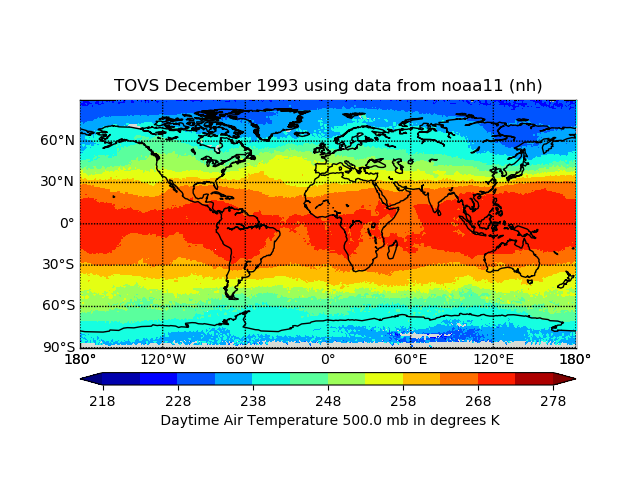
Federal
TOVS GLA MONTHLY GRIDS from NOAA-11 02 (TOVSAMNH) at GES DISC
National Aeronautics and Space Administration —
This dataset (TOVSAMNH) contains the TIROS Operational Vertical Sounder (TOVS) level 3 geophysical parameters derived using data from NOAA-11 and the physical... -
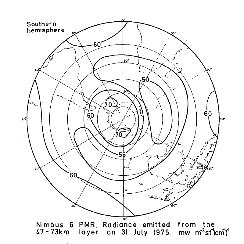
Federal
PMR/Nimbus-6 Level 1 Radiance Data from CD-ROM V001 (PMRN6L1RAD_CDROM) at GES DISC
National Aeronautics and Space Administration —
PMRN6L1RAD_CDROM is the gridded Nimbus-6 Pressure Modulated Radiometer (PMR) Level 1 Radiance Data Product. The radiances are measured at CO2 lines in the 15 micron... -
Federal
Sounder SIPS: Suomi NPP ATMS Level 3 RAMSES2 Standard Gridded Monthly V3 at GES DISC
National Aeronautics and Space Administration —
This level 3 monthly product is generated from the RAMSES (Retrieval Algorithm for Microwave Sounders in Earth Science) II algorithm.The RAMSES II algorithm is a... -
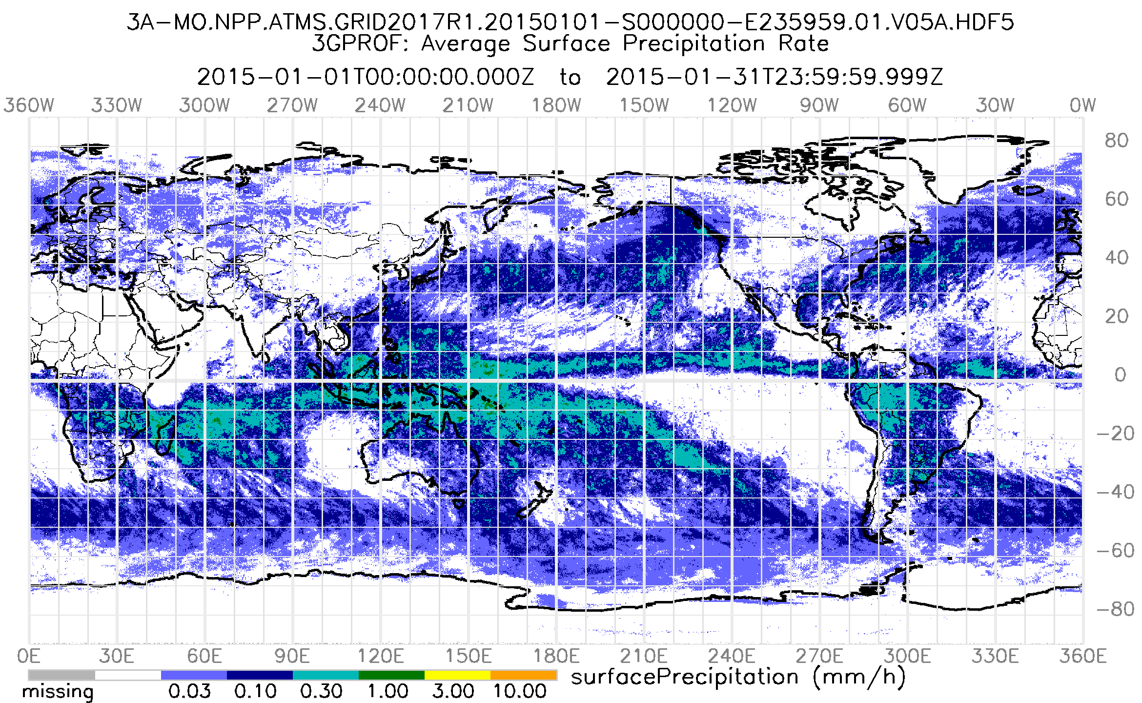
Federal
GPM ATMS on SUOMI-NPP (GPROF) Radiometer Precipitation Profiling L3 1 month 0.25 degree x 0.25 degree V07 (GPM_3GPROFNPPATMS) at GES DISC
National Aeronautics and Space Administration —
3GPROF products provide global gridded monthly/daily precipitation averages from multiple satellites that can be used for climate studies. The 3GPROF products are... -
Federal
GPM SSMIS on F17 (GPROF) Climate-based Radiometer Precipitation Profiling 1.5 hours 12 km V07 (GPM_2AGPROFF17SSMIS_CLIM) at GES DISC
National Aeronautics and Space Administration —
Version 07 is the current version of the data set. Older versions will no longer be available and have been superseded by Version 07.The 'CLIM' products differ from... -
Federal
GEOS-5 FP-IT 3D Time-Averaged Single-Level Diagnostics Geo-Colocated to OMI/Aura VIS 1-Orbit L2 Swath 13x24km V4 (OMVFPSLV) at GES DISC
National Aeronautics and Space Administration —
The GEOS-5 FP-IT 3D Time-Averaged Single-Level Diagnostics Geo-Colocated to OMI/Aura VIS 1-Orbit L2 Swath 13x24km (OMVFPSLV) provides selected parameters from GEOS-5... -
Federal
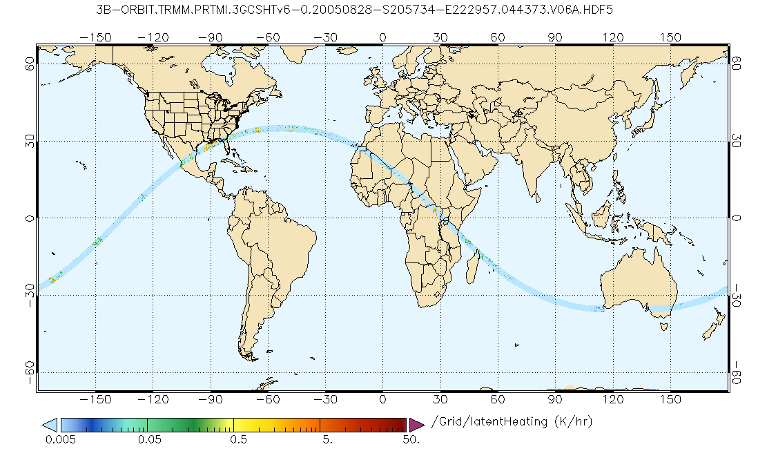
GPM PR and TMI on TRMM Combined Gridded Orbital Convective-Stratiform Latent Heating Profiles L3 1.5 hours 0.25x0.25 degree V07 (GPM_3GCSH_TRMM) at GES DISC
National Aeronautics and Space Administration —
This is the new (GPM-formated) TRMM product. It replaces the old TRMM legacy product TRMM_3G31.Version 07 is the current version of the data set. Older versions will... -
Federal
Annual Summary of Artificial Light At Night from VIIRS/S-NPP at CONUS County and Census Tract V1 (ALAN_VIIRS_CONUS) at GES DISC
National Aeronautics and Space Administration —
This product provides detailed information about the satellite-based data on artificial light at night (ALAN). The Suomi National Polar-orbiting Partnership (S-NPP)... -
Federal
Explorer-7 Thermal Radiation Experiment Selected White Sensor Temperature (Nighttime) Values V001 (EXP7L1TRTWHT) at GES DISC
National Aeronautics and Space Administration —
Explorer-7 Thermal Radiation Experiment Selected White Sensor Temperature (Nighttime) Values product contains the temperatures measured by the white sensor at night.... -
Federal
Carbon Monitoring System Lake Superior Primary Production Yearly V1 (CMSLakeSuperiorPPY) at GES DISC
National Aeronautics and Space Administration —
Yearly Average primary production/carbon fixation data for Lake Superior. The primary production data is derived using MODIS imagery with model data.The NASA Carbon...

Official websites use .gov
A
.gov website belongs to an official government
organization in the United States.
Secure .gov websites use HTTPS
A
lock (
) or https:// means you’ve safely connected to
the .gov website. Share sensitive information only on official,
secure websites.