
-
Federal
Sentinel-5P TROPOMI Total Ozone Column 1-Orbit L2 5.5km x 3.5km V1 (S5P_L2__O3_TOT_HiR) at GES DISC
National Aeronautics and Space Administration —
Starting from August 6th in 2019, Sentinel-5P TROPOMI along-track high spatial resolution (~5.5km at nadir) has been implemented.Starting from July 13th in 2020, five... -
Federal
Sentinel-5P TROPOMI Aerosol Layer Height 1-Orbit L2 5.5km x 3.5km V2 (S5P_L2__AER_LH_HiR) at GES DISC
National Aeronautics and Space Administration —
Starting from August 6th in 2019, Sentinel-5P TROPOMI along-track high spatial resolution (~5.5km at nadir) has been implemented.For data before August 6th of 2019,... -
Federal
Sentinel-5P TROPOMI Carbon Monoxide CO Column 1-Orbit L2 5.5km x 7km V2 (S5P_L2__CO_____HiR) at GES DISC
National Aeronautics and Space Administration —
Starting from August 6th in 2019, Sentinel-5P TROPOMI along-track high spatial resolution (~5.5km at nadir) has been implemented.For data before August 6th of 2019,... -
Federal
Sentinel-5P TROPOMI Aerosol Index 1-Orbit L2 5.5km x 3.5km V1 (S5P_L2__AER_AI_HiR) at GES DISC
National Aeronautics and Space Administration —
Starting from August 6th in 2019, Sentinel-5P TROPOMI along-track high spatial resolution (~5.5km at nadir) has been implemented.For data before August 6th of 2019,... -
Federal
Sentinel-5P TROPOMI Sulphur Dioxide SO2 1-Orbit L2 5.5km x 3.5km V2 (S5P_L2__SO2____HiR) at GES DISC
National Aeronautics and Space Administration —
Starting from August 6th in 2019, Sentinel-5P TROPOMI along-track high spatial resolution (~5.5km at nadir) has been implemented.Starting from July 13th in 2020, five... -
Federal
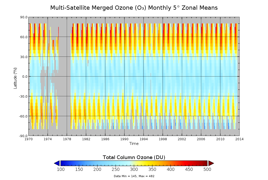
Multi-Satellite Merged Ozone (O3) Profile and Total Column 1 Month Zonal Mean L3 Global 5.0 degree Latitude Zones V1 (MSO3L3zm5) at GES DISC
National Aeronautics and Space Administration —
The merged-satellite Solar Backscattered Ultraviolet (SBUV) Level-3 monthly zonal mean (MZM) product (MSO3L3zm5) contains 1 month zonal means for profile layer and... -
Federal
Sentinel-5P TROPOMI Methane CH4 1-Orbit L2 5.5km x 7km V2 (S5P_L2__CH4____HiR) at GES DISC
National Aeronautics and Space Administration —
Starting from August 6th in 2019, Sentinel-5P TROPOMI along-track high spatial resolution (~5.5km at nadir) has been implemented.For data before August 6th of 2019,... -
Federal
Sentinel-5P TROPOMI SNPP cloud product band 7 (SWIR detector) 1-Orbit L2 5.5km x 7km V2 (S5P_L2__NP_BD7_HiR) at GES DISC
National Aeronautics and Space Administration —
Starting from August 6th in 2019, Sentinel-5P TROPOMI along-track high spatial resolution (~5.5km at nadir) has been implemented.For data before August 6th of 2019,... -
Federal
AIRS/Aqua L2 CO2 in the free troposphere (AIRS+AMSU) V005 (AIRX2STC) at GES DISC
National Aeronautics and Space Administration —
The Atmospheric Infrared Sounder (AIRS) is a grating spectrometer (R = 1200) aboard the second Earth Observing System (EOS) polar-orbiting platform, EOS Aqua. In... -
Federal
Sentinel-5P TROPOMI Tropospheric NO2 1-Orbit L2 5.5km x 3.5km V2 (S5P_L2__NO2____HiR) at GES DISC
National Aeronautics and Space Administration —
Starting from August 6th in 2019, Sentinel-5P TROPOMI along-track high spatial resolution (~5.5km at nadir) has been implemented.For data before August 6th of 2019,... -
Federal
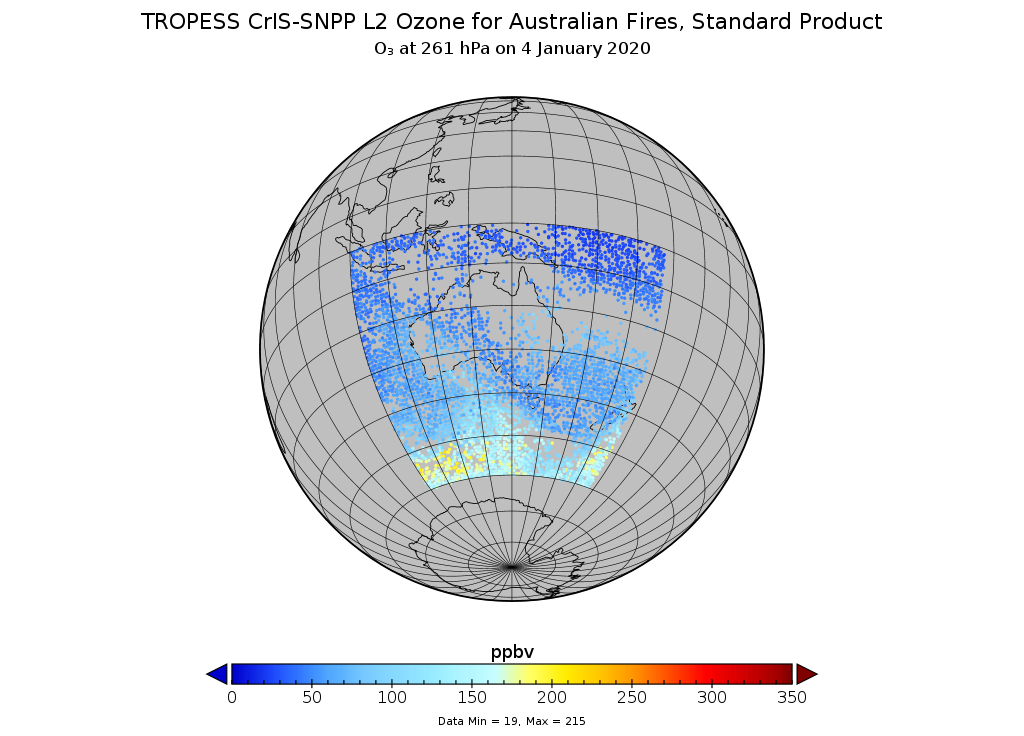
TROPESS CrIS-SNPP L2 Ozone for Australian Fires, Standard Product V1 (TRPSDL2O3CRSAUS) at GES DISC
National Aeronautics and Space Administration —
The TROPESS CrIS-SNPP L2 Ozone for Australian Fires, Standard Product contains the vertical distribution of the retrieved atmospheric state of ozone (O3), formal... -
Federal
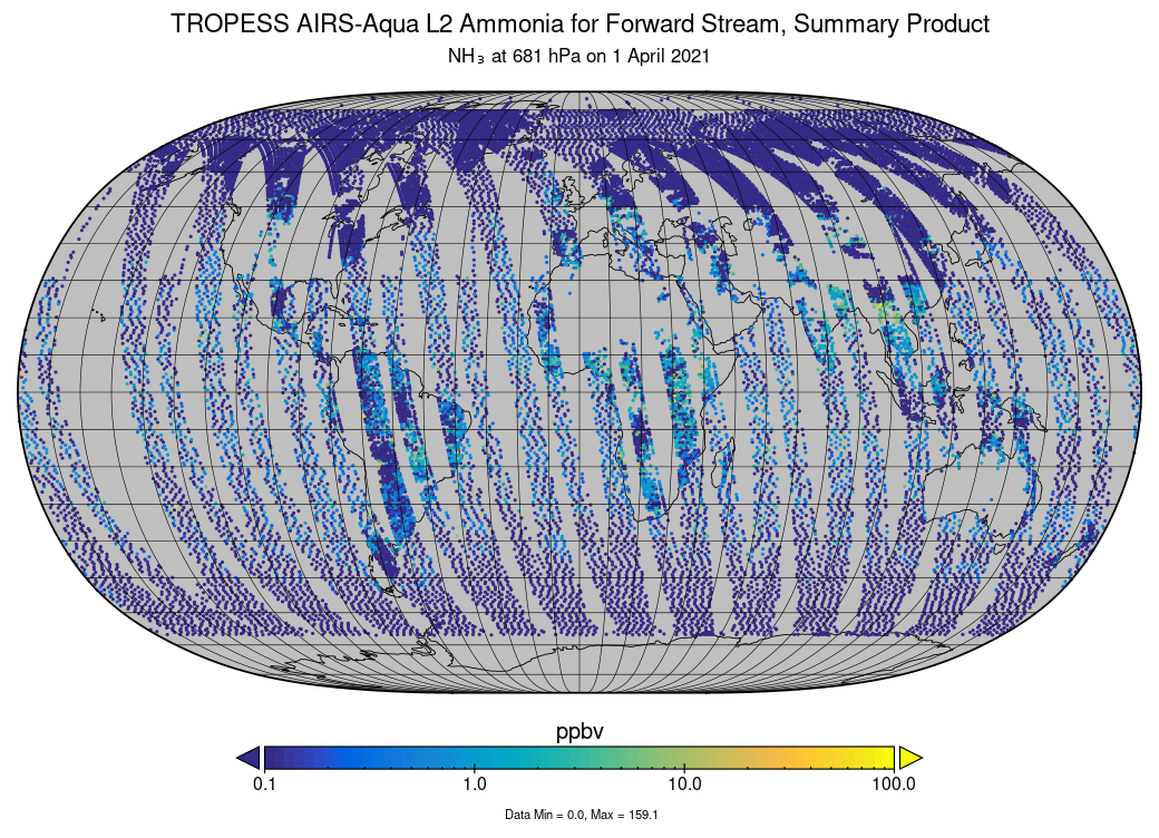
TROPESS AIRS-Aqua L2 Ammonia for Forward Stream, Summary Product V1 (TRPSYL2NH3AIRSFS) at GES DISC
National Aeronautics and Space Administration —
The TROPESS AIRS-Aqua L2 Ammonia for Forward Stream, Summary Product contains the vertical distribution of the retrieved atmospheric state of ammonia (NH3), and... -
Federal
Sounder SIPS: JPSS-1 CrIS Level 3 Comprehensive Quality Control Gridded Monthly CLIMCAPS V2 (SNDRJ1IML3CMCCP) at GES DISC
National Aeronautics and Space Administration —
WARNING: To users of the derived product “co_mmr_midtrop” (carbon monoxide mass mixing ratio to dry air [kg/kg] at ~500 hPa). This variable has a significant bias due... -
Federal
Sentinel-5P TROPOMI Tropospheric Formaldehyde HCHO 1-Orbit L2 5.5km x 3.5km V1 (S5P_L2__HCHO___HiR) at GES DISC
National Aeronautics and Space Administration —
Starting from August 6th in 2019, Sentinel-5P TROPOMI along-track high spatial resolution (~5.5km at nadir) has been implemented.Starting from July 13th in 2020, five... -
Federal
Sentinel-5P TROPOMI Carbon Monoxide CO Column 1-Orbit L2 5.5km x 7km V1 (S5P_L2__CO_____HiR) at GES DISC
National Aeronautics and Space Administration —
Starting from August 6th in 2019, Sentinel-5P TROPOMI along-track high spatial resolution (~5.5km at nadir) has been implemented.For data before August 6th of 2019,... -
Federal
Sentinel-5P TROPOMI Cloud 1-Orbit L2 5.5km x 3.5km V2 (S5P_L2__CLOUD__HiR) at GES DISC
National Aeronautics and Space Administration —
Starting from August 6th in 2019, Sentinel-5P TROPOMI along-track high spatial resolution (~5.5km at nadir) has been implemented.Starting from July 13th in 2020, five... -
Federal
Sentinel-5P TROPOMI Cloud 1-Orbit L2 7km x 3.5km V1 (S5P_L2__CLOUD_) at GES DISC
National Aeronautics and Space Administration —
Starting from August 6th in 2019, Sentinel-5P TROPOMI along-track high spatial resolution (~5.5km at nadir) has been implemented.Starting from July 13th in 2020, five... -
Federal
Sentinel-5P TROPOMI Aerosol Layer Height 1-Orbit L2 5.5km x 3.5km V1 (S5P_L2__AER_LH_HiR) at GES DISC
National Aeronautics and Space Administration —
Starting from August 6th in 2019, Sentinel-5P TROPOMI along-track high spatial resolution (~5.5km at nadir) has been implemented.For data before August 6th of 2019,... -
Federal
Sentinel-5P TROPOMI Aerosol Index 1-Orbit L2 5.5km x 3.5km V2 (S5P_L2__AER_AI_HiR) at GES DISC
National Aeronautics and Space Administration —
Starting from August 6th in 2019, Sentinel-5P TROPOMI along-track high spatial resolution (~5.5km at nadir) has been implemented.For data before August 6th of 2019,... -
Federal
Sentinel-5P TROPOMI Tropospheric Formaldehyde HCHO 1-Orbit L2 5.5km x 3.5km V2 (S5P_L2__HCHO___HiR) at GES DISC
National Aeronautics and Space Administration —
Starting from August 6th in 2019, Sentinel-5P TROPOMI along-track high spatial resolution (~5.5km at nadir) has been implemented.Starting from July 13th in 2020, five...

Official websites use .gov
A
.gov website belongs to an official government
organization in the United States.
Secure .gov websites use HTTPS
A
lock (
) or https:// means you’ve safely connected to
the .gov website. Share sensitive information only on official,
secure websites.