
-
Federal
TRMM Ground Validation Radar Site Rain Rate Map L2 1 hour 2 km V7 (TRMM_2A53UW) at GES DISC
National Aeronautics and Space Administration —
This dataset is part of the University of Washington TRMM Ground Validation products. Instantaneous rain rate cartesian grid based on baseUW and 2A54UW. Units are... -
Federal
THIR/Nimbus-7 Images of Daytime and Nighttime Brightness Temperature on 70 mm Film V001 (THIRN7IM) at GES DISC
National Aeronautics and Space Administration —
THIRN7IM is the Nimbus-7 Temperature-Humidity Infrared Radiometer (THIR) data product consisting of daily montages of brightness temperatures measured at 6.7 and 11.5... -
Federal
TRMM Ground Validation Radar Site Rain Rate Map L2 1 hour 2 km V7 (TRMM_2A53) at GES DISC
National Aeronautics and Space Administration —
'Radar Site Rain Map', is an instantaneous surface rain rate map in Cartesian coordinates with a 2 km horizontal resolution. At single radar sites, the map covers an... -
Federal
Sentinel-5P TROPOMI Tropospheric Formaldehyde HCHO 1-Orbit L2 7km x 3.5km V1 (S5P_L2__HCHO__) at GES DISC
National Aeronautics and Space Administration —
Starting from August 6th in 2019, Sentinel-5P TROPOMI along-track high spatial resolution (~5.5km at nadir) has been implemented. Starting from July 13th in 2020,... -
Federal
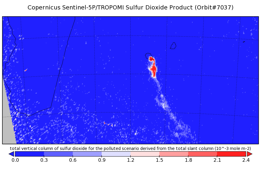
Sentinel-5P TROPOMI Near-Real-Time (NRT) Sulphur Dioxide SO2 1-Orbit L2 5.5km x 3.5km V2 (S5P_L2__SO2____HiR_NRT) at GES DISC
National Aeronautics and Space Administration —
The Sentinel-5P TROPOMI Near Real Time (NRT) Sulphur Dioxide SO2 1-Orbit L2 5.5km x 3.5km V2 (S5P_L2__SO2_HiRNRT) at GES DISC is the near real time version of the... -
Federal
TRMM Precipitation Radar Surface Cross-Section L2 1.5 hours V7 (TRMM_2A21) at GES DISC
National Aeronautics and Space Administration —
The new version of these data is in GPM-like format (consistent with the GPM Dual-frequency Radar data format), and can be found under the name GPM_2APR. This is the... -
Federal
AIRS/Aqua L1B Near Real Time (NRT) Infrared (IR) quality assurance subset V005 (AIRIBQAP_NRT) at GES DISC
National Aeronautics and Space Administration —
The AIRS Level 1B Near Real Time (NRT) product (AIRIBQAP_NRT_005) differs from the routine product (AIRIBQAP_005) in 2 ways to meet the three hour latency... -
Federal
THIR/Nimbus-4 Images of Daytime and Nighttime Brightness Temperature at 6.7 microns on 70 mm Film V001 (THIRN4IMCH67) at GES DISC
National Aeronautics and Space Administration —
THIRN4IMCH67 is the Nimbus-4 Temperature-Humidity Infrared Radiometer (THIR) data product consisting of daily montages of brightness temperatures measured at 6.7... -
Federal
TRMM Ground Validation Calibrated QC Radar Reflectivity Full Volume Scan L1C 1 hour V7 (TRMM_1C51) at GES DISC
National Aeronautics and Space Administration —
The purpose of the 1C51 algorithm is to remove non-meteorological radar echoes that adversely affect the quality of higher level products, such as clutter associated... -
Federal
TRMM Ground Validation Rain Existence L2 1 month V7 (TRMM_2A52) at GES DISC
National Aeronautics and Space Administration —
The TRMM_2A52 product displays the existence of rain in the radar volume scan. 'Existence' is the fraction of the radar FOV which has measurable precipitation. The GV... -
Federal
TRMM Ground Validation Radar Site Rain Totals Map L3 5 days 2 km V7 (TRMM_3A53) at GES DISC
National Aeronautics and Space Administration —
This is the 5-day accumulation of the 2A53 product, 'Radar Site Rain Map', which originally is an instantaneous surface rain rate map in Cartesian coordinates with a... -
Federal
HRIR/Nimbus-3 Images of Daytime and Nighttime Brightness Temperature on 70 mm Film V001 (HRIRN3IM) at GES DISC
National Aeronautics and Space Administration —
HRIRN3IM is the Nimbus-3 High-Resolution Infrared Radiometer (HRIR) data product containing scanned negatives of photofacsimile 70mm film strips. The images contain... -
Federal
Sentinel-5P TROPOMI Sulphur Dioxide SO2 1-Orbit L2 7km x 3.5km V1 (S5P_L2__SO2___) at GES DISC
National Aeronautics and Space Administration —
Starting from August 6th in 2019, Sentinel-5P TROPOMI along-track high spatial resolution (~5.5km at nadir) has been implemented. Starting from July 13th in 2020,... -
Federal
SAMS/Nimbus-7 Level 1 Radiance Data V001 (SAMSN7L1RAT) at GES DISC
National Aeronautics and Space Administration —
SAMSN7L1RAT is the gridded Nimbus-7 Stratospheric and Mesospheric Sounder (SAMS) Level 1 Radiance Data Product. The radiances were selected to derive gas... -
Federal
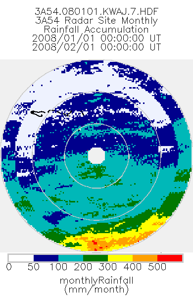
TRMM Ground Validation Radar Site Rain Type Totals Map L3 1 month 2 km V7 (TRMM_3A54UW) at GES DISC
National Aeronautics and Space Administration —
This dataset is part of the University of Washington TRMM Ground Validation products. Monthly rain accumulation cartesian grid based on 2A53UW. Units are mm. Min... -
Federal
HRIR/Nimbus-2 Images of Nighttime Brightness Temperature on 70 mm Film V001 (HRIRN2IM) at GES DISC
National Aeronautics and Space Administration —
HRIRN2IM is the Nimbus-2 High-Resolution Infrared Radiometer (HRIR) data product containing scanned negatives of photofacsimile 70mm film strips. The images contain... -
Federal
SAMS/Nimbus-7 Level 1 Radiance Data from CD-ROM V001 (SAMSN7L1RAD_CDROM) at GES DISC
National Aeronautics and Space Administration —
SAMSN7L1RAD_CDROM is the gridded Nimbus-7 Stratospheric and Mesospheric Sounder (SAMS) Level 1 Radiance Data Product. The radiances were selected to derive gas... -
Federal
TRMM Ground Validation Rain Gauge Rain Rate L2 1 month V7 (TRMM_2A56) at GES DISC
National Aeronautics and Space Administration —
The program rgmin generates 1-minute hourly rain rates from discrete tipping bucket rain gauge data by applying an interpolation algorithm. The interpolating routine... -
Federal
HRIR/Nimbus-1 Images of Nighttime Brightness Temperature on 70 mm Film V001 (HRIRN1IM) at GES DISC
National Aeronautics and Space Administration —
HRIRN1IM is the Nimbus-1 High-Resolution Infrared Radiometer (HRIR) data product containing scanned negatives of photofacsimile 70mm film strips. The images contain... -
Federal
TRMM Ground Validation Radar Site 3D Reflectivity L2 1 hour V7 (TRMM_2A55UW) at GES DISC
National Aeronautics and Space Administration —
This dataset is part of the University of Washington TRMM Ground Validation products. Multiple-level cartesian grid containing output of NCAR SPRINT interpolation of...

Official websites use .gov
A
.gov website belongs to an official government
organization in the United States.
Secure .gov websites use HTTPS
A
lock (
) or https:// means you’ve safely connected to
the .gov website. Share sensitive information only on official,
secure websites.