

1,135 datasets found
-
Federal
USGS Global Forest Observations Initiative (GFOI) Peru recent views
National Aeronautics and Space Administration —
The Global Forest Observations Initiative (GFOI) is an initiative of the inter-governmental Group on Earth Observations (GEO) that aims to: foster the sustained... -
Federal
USGS Group on Earth Observations (GEO) Global Agricultural Monitoring (GLAM) Algeria recent views
National Aeronautics and Space Administration —
The objective of GEO is to fulfil a vision of a world where decisions and actions are informed by coordinated, comprehensive and sustained Earth Observation (EO).... -
County
2019 Farm Tour recent views
Montgomery County of Maryland —
List of Farm Tour participants for the 2019 season. Updated annually. -
State
California Important Farmland: 2014 recent views
State of California —
Established in 1982, Government Code Section 65570 mandates FMMP to biennially report on the conversion of farmland and grazing land, and to provide maps and data to... -
State
California Important Farmland: 1990 recent views
State of California —
Established in 1982, Government Code Section 65570 mandates FMMP to biennially report on the conversion of farmland and grazing land, and to provide maps and data to... -
State
California Important Farmland: 1994 recent views
State of California —
Established in 1982, Government Code Section 65570 mandates FMMP to biennially report on the conversion of farmland and grazing land, and to provide maps and data to... -
Federal
Crop Year 2013 Drought Specific Disaster Designations Map recent views
Department of Agriculture —
Crop year 2013 US map at the county level shows drought-specific disaster designations across the country under USDA's amended rule. -
Federal
Snowchange Oral History - Work Among the Kolyma River Indigenous Societies in Siberia, Russia, Version 1 recent views
National Aeronautics and Space Administration —
This data set includes oral history accounts from Indigenous people participating in the Snowchange project in Siberia, Russia. It provides geographic and... -
Federal
U.S. Heat Demand by Sector for Potential Application of Direct Use Geothermal recent views
Department of Energy —
This dataset includes heat demand for potential application of direct use geothermal broken down into 4 sectors: agricultural, commercial, manufacturing and... -
Federal
Landscape Intactness Index for the Western United States recent views
Department of the Interior —
Landscape intactness has been defined as a quantifiable estimate of naturalness measured on a gradient of anthropogenic influence and based on available spatial data.... -
Federal
The genome of cowpea (Vigna unguiculata [L.] Walp.) recent views
US Agency for International Development —
Cowpea (Vigna unguiculata [L.] Walp.) is a major crop for worldwide food and nutritional security, especially in sub-Saharan Africa, that is resilient to hot and... -
Federal
WLDAS Noah-MP 3.6 Land Surface Model L4 Daily 0.01 degree x 0.01 degree Version D1.0 (WLDAS_NOAHMP001_DA1) at GES DISC recent views
National Aeronautics and Space Administration —
The Western Land Data Assimilation System (WLDAS), developed at Goddard Space Flight Center (GSFC) and funded by the NASA Western Water Applications Office, provides... -
Federal
Data from: Microbial volatile organic compounds mediate attraction by a primary but not secondary stored product insect pest in wheat recent views
Department of Agriculture —
This dataset is associated with the forthcoming publication entitled, "Microbial volatile organic compounds mediate attraction by a primary but not secondary stored... -
Federal
Attributes for NHDPlus Version 2.1 Catchments and Modified Routing of Upstream Watersheds for the Conterminous United States: Crop Land Data Layer 2013 recent views
Department of the Interior —
This tabular data set represents the percent of land cover classes from the 2013 Crop land Data Layer compiled for two spatial components of the NHDPlus version 2... -
Federal
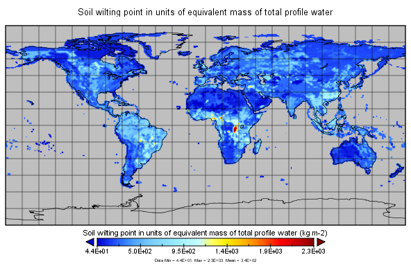
MERRA-2 const_2d_lnd_Nx: 2d, constants Land Surface Diagnostics 0.625 x 0.5 degree V5.12.4 (M2C0NXLND) at GES DISC recent views
National Aeronautics and Space Administration —
M2C0NXLND (or const_2d_lnd_Nx) is a data collection in Modern-Era Retrospective analysis for Research and Applications version 2 (MERRA-2). This collection consists... -
Federal
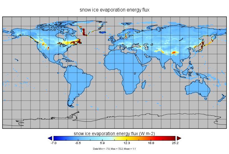
MERRA-2 tavgM_2d_lnd_Nx: 2d,Monthly mean,Time-Averaged,Single-Level,Assimilation,Land Surface Diagnostics 0.625 x 0.5 degree V5.12.4 (M2TMNXLND) at GES DISC recent views
National Aeronautics and Space Administration —
M2TMNXLND (or tavgM_2d_lnd_Nx) is a time-averaged 2-dimensional monthly mean data collection in Modern-Era Retrospective analysis for Research and Applications... -
Federal
USDA Rural Development Single Family Section 502 Direct Active Loans by Congressional District recent views
Department of Agriculture —
Active loan characteristics aggregated at the Congressional District level of geography, including number of loans, average loan amount, average loan amount by 5 year... -
State
California Important Farmland: 2016 recent views
State of California —
Established in 1982, Government Code Section 65570 mandates FMMP to biennially report on the conversion of farmland and grazing land, and to provide maps and data to... -
Federal
BioProject ID PRJNA592969 recent views
U.S. Environmental Protection Agency —
DNA sequences--already publicly available -
Federal
Geodatabase of files associated with the Assessment of Soil and Water Resources in The Organ Mountains-Desert Peaks National Monument, New Mexico recent views
Department of the Interior —
This U.S. Geological Survey (USGS) data release presents the geospatial data used to assess the hydrologic and soil resources of the Organ Mountains-Desert Peaks...
1,135 datasets found