
-
Federal
H10237: NOS Hydrographic Survey , St. Andrew Bay, Florida, 1987-05-07
National Oceanic and Atmospheric Administration, Department of Commerce —
The National Oceanic and Atmospheric Administration (NOAA) has the statutory mandate to collect hydrographic data in support of nautical chart compilation for safe... -
Federal
NOAA Point Shapefile - 100m2 Fish Density of Flower Garden Banks National Marine Sanctuary, United States, R/V Manta, Shallow Dive Cruise, 2012, WGS84
National Oceanic and Atmospheric Administration, Department of Commerce —
The design of this field mission is three fold: (1) to spatially characterize the distribution, abundance and size of both reef fishes and macro invertebrates within... -
Federal
F00055: NOS Hydrographic Survey , 1945-08-07
National Oceanic and Atmospheric Administration, Department of Commerce —
The National Oceanic and Atmospheric Administration (NOAA) has the statutory mandate to collect hydrographic data in support of nautical chart compilation for safe... -
Federal
D00141: NOS Hydrographic Survey , Chandeleur Sound, Louisiana, 2009-01-24
National Oceanic and Atmospheric Administration, Department of Commerce —
The National Oceanic and Atmospheric Administration (NOAA) has the statutory mandate to collect hydrographic data in support of nautical chart compilation for safe... -
Federal
F00546: NOS Hydrographic Survey , Vermillion Bay and Approahes, Louisiana, 2007-11-21
National Oceanic and Atmospheric Administration, Department of Commerce —
The National Oceanic and Atmospheric Administration (NOAA) has the statutory mandate to collect hydrographic data in support of nautical chart compilation for safe... -
Federal
2015 NOAA NGS Ortho-rectified Mean Low Low Water Color Mosaic of Augusta to Newcastle, Maine
National Oceanic and Atmospheric Administration, Department of Commerce —
This data set contains ortho-rectified mosaic tiles, created as a product from the NOAA Integrated Ocean and Coastal Mapping (IOCM) initiative. The source imagery was... -
Federal
2015 NOAA NGS Ortho-rectified Mean High Water Near-Infrared Mosaic of Augusta to Newcastle, Maine
National Oceanic and Atmospheric Administration, Department of Commerce —
This data set contains ortho-rectified mosaic tiles, created as a product from the NOAA Integrated Ocean and Coastal Mapping (IOCM) initiative. The source imagery was... -
Federal
2015 NOAA NGS Ortho-rectified MHW Color Mosaic of Carrabelle to Cedar Key, FL
National Oceanic and Atmospheric Administration, Department of Commerce —
This data set contains ortho-rectified mosaic tiles, created as a product from the NOAA Integrated Ocean and Coastal Mapping (IOCM) initiative. The source imagery was... -
Federal
Generator Fleet Characteristics Model
Department of Commerce —
When run, the GFCM creates tabular and graphical data of the hourly operating status and market outcomes for the generators that make up the electric generating fleet. -
Federal
AM Bench 2022 ASTM E8 Macroscale Tension at Different Strain Rates on As-built IN625
Department of Commerce —
Macro-scale tensile data on additively manufactured (AM) IN625 in the as-built microstructural condition at room temperature and at different strain rates are... -
Federal
AM Bench 2018 Residual Elastic Strain Measurements of 3D Additive Manufacturing Builds of IN625 Artifacts Using Neutron Diffraction and Synchrotron X-ray Diffraction
Department of Commerce —
The development of large residual elastic strains and stresses during laser powder-bed fusion (LPBF) additive manufacturing is one of the most significant barriers to... -
Federal
analphipy: A python package to analyze pair-potential metrics.
Department of Commerce —
analphipy is a python package to calculate metrics for classical models for pair potentials. It provides a simple and extendable api for pair potentials creation.... -
Federal
Data for the paper "EIT spectra of Rydberg atoms dressed with dual tone radio-frequency fields"
Department of Commerce —
This dataset contains the data for the figures in the paper "EIT spectra of Rydberg atoms dressed with dual tone radio-frequency fields", submitted to Physical Review... -
Federal
TROPICS05 L2B Neural-network Atmospheric Vertical Temperature & Moisture Profiles V0.2
National Aeronautics and Space Administration —
The "Time-Resolved Observations of Precipitation structure and storm Intensity with a Constellation of Smallsats" (TROPICS) mission has a goal of providing nearly... -
Federal
Optical Modeling of Single Asian Dust and Marine Air Particles: A Comparison with Geometric Particle Shapes for Remote Sensing
Department of Commerce —
The project that produced these data involved the analysis and modeling of atmospheric Asian dust particles and background marine air particles collected in Hawaii,... -
Federal
BOREAS Landsat TM Level-3p Imagery: Geocoded and Scaled At-Sensor Radiance
National Aeronautics and Space Administration —
For BOREAS, the level-3p Landsat TM data were used to supplement the level-3s Landsat TM products. Along with the other remotely sensed images, the Landsat TM images... -
Federal
GPM PR on TRMM Reflectivity, Precipitation Characteristics and Rate, at Surface and Profile L2 1.5 hours V07 (GPM_2APR) at GES DISC
National Aeronautics and Space Administration —
This is the new, GPM-like, format for TRMM Precipitation Radar L2 data that now incorporates what was known as 2A21, 2A23 and 2A25 datasets.The primary purpose of... -
Federal
GHRSST Level 2P Global skin Sea Surface Temperature from the Infrared Atmospheric Sounding Interferometer (IASI) on the Metop-B satellite (GDS V2) produced by OSI SAF
National Aeronautics and Space Administration —
A Group for High Resolution Sea Surface Temperature (GHRSST) Level 2P dataset based on multi-channel sea surface temperature (SST) retrievals generated in real-time... -
Federal
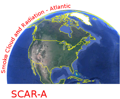
CAR SCAR-A Sulfates, Clouds, and Radiation-Atlantic BRDF Measurements BRDF V2 (CAR_SCARA_BRDF) at GES DISC
National Aeronautics and Space Administration —
The objectives for the SCAR mission are to advance our knowledge of how the physical, chemical and radiative processes in our atmosphere are affected by sulfate... -
Federal
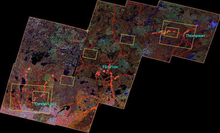
BOREAS Follow-On DSP-01 Landsat TM Land Cover Mosaic of the BOREAS Transect
National Aeronautics and Space Administration —
The objective of this land cover mosaic is to provide a data product that characterises the detailed land cover of a significant portion of the BOREAS Region. Seven...

Official websites use .gov
A
.gov website belongs to an official government
organization in the United States.
Secure .gov websites use HTTPS
A
lock (
) or https:// means you’ve safely connected to
the .gov website. Share sensitive information only on official,
secure websites.
.jpg)