

1,615 datasets found for "Ag客户端✅澳门葡京赌场官方网站-网址【079.one】㊙️最火爆PG电子超高爆奖率,注册即送38元.QxKgTcDNMqKljq"
-
Federal
Utah FORGE 3-2417: Pulsed Interference Tests at Wells 16A(78)-32 and 16B(78)-32 - September 2024
Department of Energy —
This archive contains data and a report from Pulse Interference Tests (PITs), which were conducted on September 4, 2024, immediately following a 30-day recirculation... -
Federal
Water Quality data CP
U.S. Environmental Protection Agency —
The Water Quality Dataset contains field and laboratory data that were collected at a field-scale permeable reactive barrier. Environmental samples were collected... -
Federal
anomaly fans NGDA
Department of the Interior —
Since 1998, geoscientists at the Bureau of Ocean Energy Management (BOEM) have identified and mapped over 31,000 water bottom (seafloor) acoustic amplitude anomalies... -
Federal
Vegetation Taxa List for Rocky Mountain National Park Wetlands Ecological Integrity monitoring (2007-2017).
Department of the Interior —
This table lists all taxa detected at long-term wetland ecological integrity monitoring sites by the NPS Rocky Mountain Network in Rocky Mountain National Park. The... -
State
Erosion Susceptibility Sites
State of Connecticut —
Connecticut Erosion Susceptibility a 1:24,000-scale, polygon feature-based layer that was developed as a predictive tool to show areas most susceptible to terrace... -
Federal
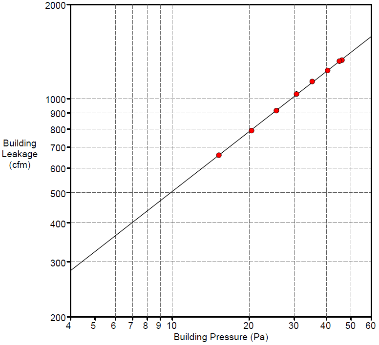
Field Testing of Compartmentalization Methods for Multifamily Construction - Washington DC
Department of Energy —
BSC TO5 Task 2.1 Field Testing of Compartmentalization Methods for Multifamily Construction - Capitol Heights, MD 20743 A building comprising five vertical townhome... -
Federal
The contribution of the neuroendocrine system to adaption after repeated daily ozone exposure in rats
U.S. Environmental Protection Agency —
we hypothesized that ozone-adaptation is linked to diminution of neuroendocrine stress-axes activation and glucocorticoid levels. Male Wistar-Kyoto-rats (12-week-old)... -
Federal
Simbol Materials Lithium Extraction Operating Data From Elmore and Featherstone Geothermal Plants
Department of Energy —
The data provided in this upload is summary data from its Demonstration Plant operation at the geothermal power production plants in the Imperial Valley. The data... -
Federal
Purdue University: Results of B-Value Tests for Rock Saturation
Department of Energy —
This dataset includes an Excel file with the results of B-value tests to determine the magnitude of the back pressure required for full saturation of Sierra White... -
University
Hydrography for Eddy County, New Mexico, 2006se TIGER
Earth Data Analysis Center, University of New Mexico —
The 2006 Second Edition TIGER/Line files are an extract of selected geographic and cartographic information from the Census TIGER database. The geographic coverage... -
Federal
Monitoring of Double-Stud Wall Moisture Conditions in the Northeast
Department of Energy —
BSC TO5 Task 2.2 Monitoring of Double Stud Wall Moisture Conditions in the Northeast Field test data available for wood moisture contents, temperature, and relative... -
Federal
LRIR/Nimbus-6 Level 2 Inverted Profiles of Temperature and Ozone V001 (LRIRN6L2IPAT) at GES DISC
National Aeronautics and Space Administration —
LRIRN6L2IPAT is the Nimbus-6 Limb Radiance Inversion Radiometer (LRIR) Level 2 Inverted Profiles of Temperature and Ozone data product. The product contains daily... -
Federal
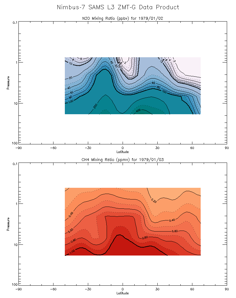
SAMS/Nimbus-7 Level 3 Zonal Means Composition Data V001 (SAMSN7L3ZMTG) at GES DISC
National Aeronautics and Space Administration —
SAMSN7L3ZMTG is the Nimbus-7 Stratospheric and Mesospheric Sounder (SAMS) Level 3 Zonal Means Composition Data Product. The Earth's surface is divided into 2.5-deg... -
Federal
TIROS-4 Medium-Resolution Scanning Radiometer Level 1 Final Meteorological Radiation Data V001 (TIROS4L1FMRT) at GES DISC
National Aeronautics and Space Administration —
TIROS-4 Medium-Resolution Scanning Radiometer Level 1 Final Meteorological Radiation Data (FMRT) product contains radiances expressed in five infrared/visible... -
Federal
TIROS-3 Medium-Resolution Scanning Radiometer Level 1 Final Meteorological Radiation Data V001 (TIROS3L1FMRT) at GES DISC
National Aeronautics and Space Administration —
TIROS-3 Medium-Resolution Scanning Radiometer Level 1 Final Meteorological Radiation Data (FMRT) product contains radiances expressed in five infrared/visible... -
Federal
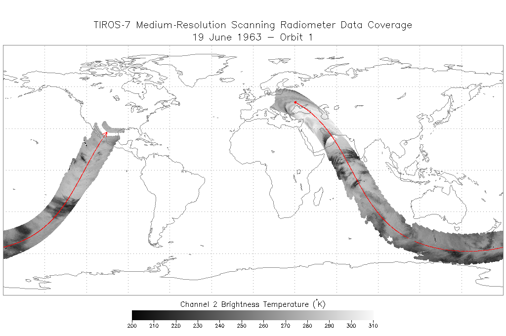
TIROS-7 Medium-Resolution Scanning Radiometer Level 1 Final Meteorological Radiation Data V001 (TIROS7L1FMRT) at GES DISC
National Aeronautics and Space Administration —
TIROS-7 Medium-Resolution Scanning Radiometer Level 1 Final Meteorological Radiation Data (FMRT) product contains radiances expressed in five infrared/visible... -
State
Los Angeles River Restoration and Access (LLARRA) Water Quality Analysis - Lower Los Angeles River - 2024-2025
State of California —
WCB Grant 2023114: Lower Los Angeles River Restoration and Access: Data includes one (1) year of water quality analysis to inform the design and serve as a baseline... -
Federal
BLM Natl WesternUS FIAT Project Planning Areas 2015 Polygon
Department of the Interior —
This data represents a management strategy of the Fire and Invasives Assessment Tool (FIAT). Project Planning Area (PPA) polygons are part of the FIAT Step 2 process.... -
Federal
VMS Groundfish 2010-2017 (BOEM)
Department of the Interior —
2010-2017 Vessel Monitoring System (VMS) data were used from the NOAA Office of Law Enforcement to create this fishing effort dataset for the U.S. West Coast. The... -
Federal
CRED REA Algal Assessments, Maro Reef, Northwestern Hawaiian Islands 2002 (NODC Accession 0010352)
National Oceanic and Atmospheric Administration, Department of Commerce —
Twelve quadrats were sampled along 2 consecutively-placed, 25m transect lines as part of Rapid Ecological Assessments conducted at 5 sites at Maro Reef in the...
1,615 datasets found for "Ag客户端✅澳门葡京赌场官方网站-网址【079.one】㊙️最火爆PG电子超高爆奖率,注册即送38元.QxKgTcDNMqKljq"