
-
Federal
BOREAS TGB-10 Oxidant Concentration Data over the SSA
National Aeronautics and Space Administration —
The BOREAS TGB-10 team collected several trace gas data sets in their efforts to determine the role of biogenic hydrocarbon emissions with respect to boreal forest... -
Federal
Bass Strait Pre-SWOT Level-4 Hourly MITgcm LLC4320 Native Grid 2km Oceanographic Dataset Version 1.0
National Aeronautics and Space Administration —
This dataset provides a regional multivariate oceanographic state estimate from a global ocean numerical simulation with a focus on the Bass Strait region. The global... -
Federal
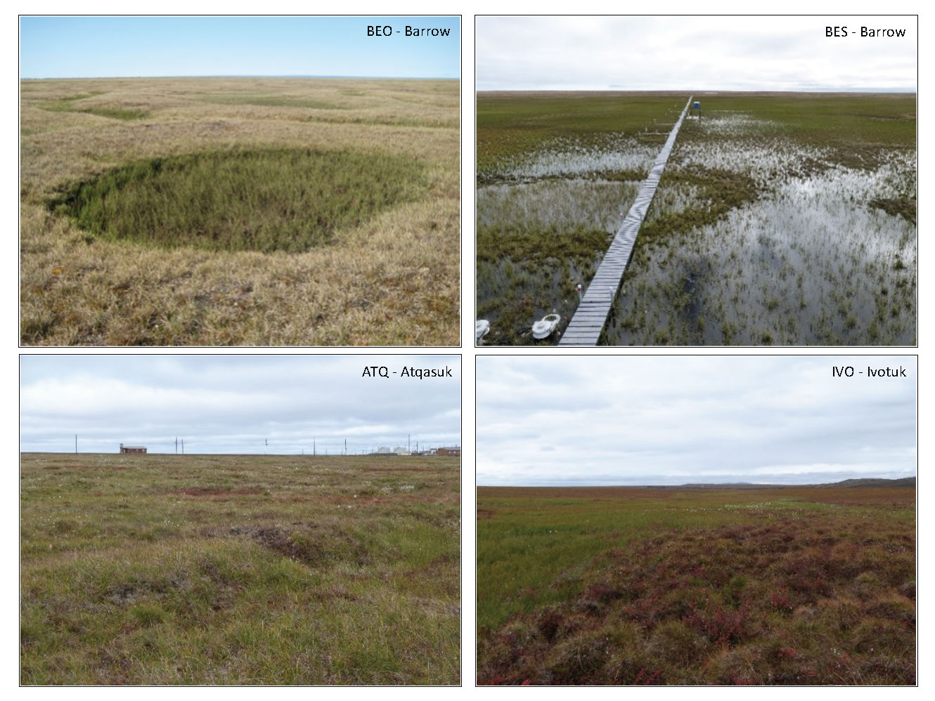
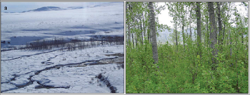
Arctic Vegetation Plots in Flux Tower Footprints, North Slope, Alaska, 2014
National Aeronautics and Space Administration —
This data set provides vegetation, environmental, and soil data collected from plots located in the footprints of eddy covariance flux towers along a 300 km north-... -
Federal
BOREAS TE-18 Biomass Density Image of the SSA
National Aeronautics and Space Administration —
This biomass density image covers almost the entire BOREAS SSA. The pixels for which biomass density is computed include areas that are in conifer land cover classes... -
Federal
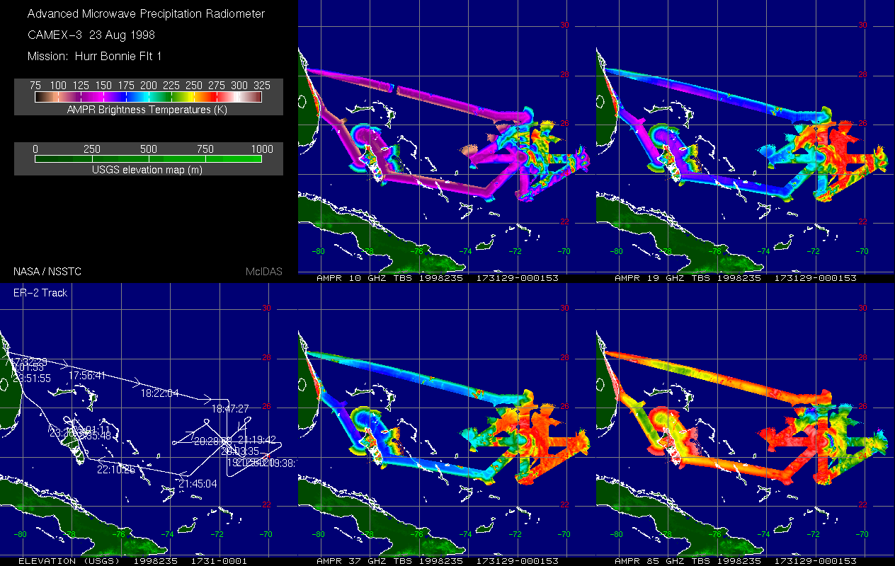
CAMEX-3 AMPR BRIGHTNESS TEMPERATURE (TB) V1
National Aeronautics and Space Administration —
The Advanced Microwave Precipitation Radiometer (AMPR) was deployed during the Third Convection and Moisture Experiment (CAMEX-3). AMPR data were collected at four... -
Federal
ASTER Global Emissivity Dataset, 1 kilometer, HDF5 V003
National Aeronautics and Space Administration —
The Terra Advanced Spaceborne Thermal Emission and Reflection Radiometer (ASTER) Global Emissivity Dataset (GED) land surface temperature and emissivity (LST&E)... -
Federal
BOREAS TF-01 SSA-OA Soil Characteristics Data
National Aeronautics and Space Administration —
The BOREAS TF-01 team collected several data sets in support of its efforts to characterize and interpret soil information at the SSA-OA tower site in 1994 as part of... -
Federal
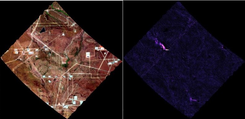
AVIRIS-3 L2B Greenhouse Gas Enhancements, Facility Instrument Collection
National Aeronautics and Space Administration —
This dataset contains Level 2B (L2b) enhancements of greenhouse gasses (GHG) derived from imagery collected by the Airborne Visible / Infrared Imaging Spectrometer-3... -
Federal
Aquarius Official Release Level 3 Sea Surface Spiciness Standard Mapped Image Monthly Climatology Data V5.0
National Aeronautics and Space Administration —
Aquarius Level 3 sea surface spiciness standard mapped image data contains gridded 1 degree spatial resolution spice data averagedover daily, 7 day, monthly, and... -
Federal
Earth Radiation Budget Experiment (ERBE) S-10 Medium Field of View (MFOV) Numerical Filter (NF) Radiant Flux and Albedo
National Aeronautics and Space Administration —
ERBE_S10_MFOV_NF_NAT_1 is the Earth Radiation Budget Experiment (ERBE) S-10 Medium Field of View (MFOV) Numerical Filter (NF) Radiant Flux and Albedo data product.... -
Federal
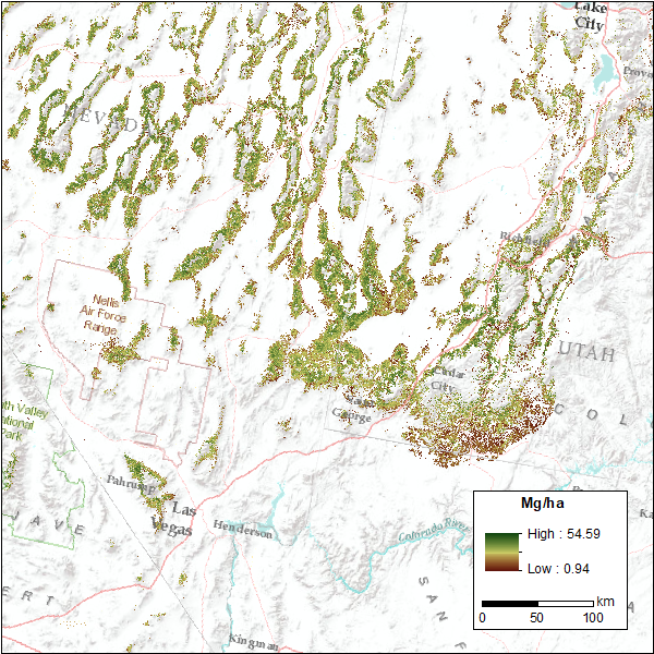
CMS: Pinyon-Juniper Forest Live Aboveground Biomass, Great Basin, USA, 2000-2016
National Aeronautics and Space Administration —
This dataset provides annual maps of live aboveground tree biomass (Mg/ha) for pinyon-juniper forests across the Great Basin of the Western USA for the years... -
Federal
BOREAS TGB-05 CO2, CH4, and CO Chamber Flux Data over the NSA
National Aeronautics and Space Administration —
The BOREAS TGB-05 team collected a variety of trace gas concentration and flux measurements at several NSA sites. This data set contains carbon dioxide (CO2), methane... -
Federal
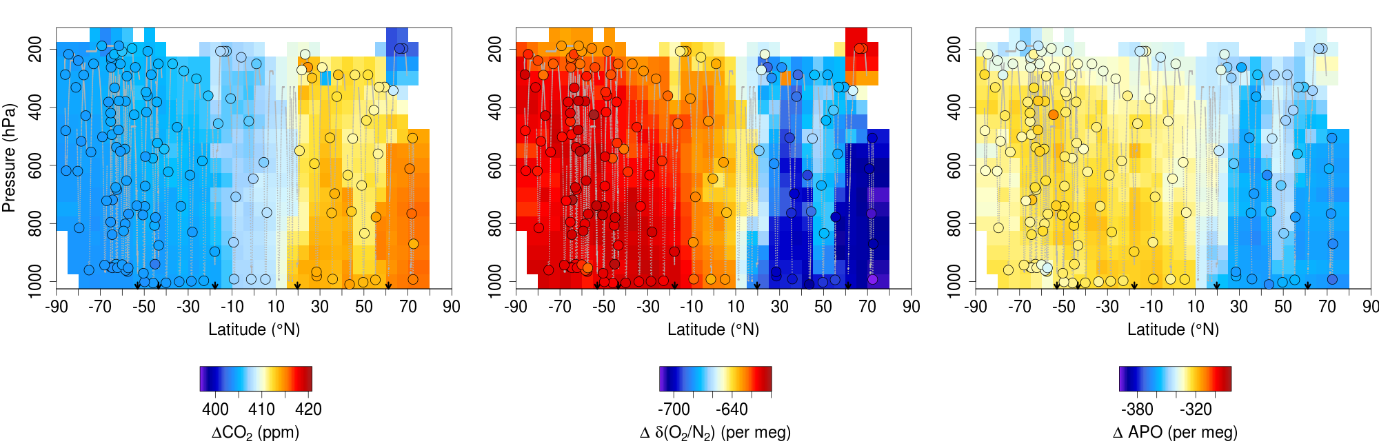
ATom: L2 In Situ Measurements from the NCAR Airborne Oxygen Instrument (AO2), V2
National Aeronautics and Space Administration —
This dataset provides in situ atmospheric oxygen and carbon dioxide concentrations measured by the NCAR Airborne Oxygen Instrument (AO2) during airborne campaigns... -
Federal
Arctic Vegetation Plots, Poplars, Arctic and Interior AK and YT, Canada, 2003-2005
National Aeronautics and Space Administration —
This data set provides vegetation cover and environmental plot data collected from 32 balsam poplar (Populus balsamifera L., Salicaceae) vegetation plots located on... -
Federal
BOREAS/SRC AMS Suite B Surface Meteorological and Radiation Data: 1994
National Aeronautics and Space Administration —
The Saskatchewan Research Council (SRC) collected surface meteorological and radiation data from December, 1993 until Decemb er 1996. The data set is comprised of the... -
Federal
BOREAS Level-0 AOCI Imagery: Digital Counts in BIL Format
National Aeronautics and Space Administration —
The level-0 AOCI imagery, along with the other remotely sensed images, was collected to provide spatially extensive information about radiant energy over the primary... -
Federal
IBEX High Energy Neutral Atom Imager (ENA-Hi) Data Release 10, Compton-Getting corrected, not Survival Probability corrected, Antiram direction, West Longitude Ecliptic Maps, Level H3 (H3), 7 year average Data
National Aeronautics and Space Administration —
The IBEX ENA-Hi and IBEX ENA-Lo data sets are from Release 10 of all-sky map data for the first seven years, 2009-2015, in the form of antiram direction Hydrogen, H,... -
Federal
IBEX High Energy Neutral Atom Imager (ENA-Hi) Data Release 10, Compton-Getting corrected, not Survival Probability corrected, Antiram direction, West Longitude Ecliptic Maps, 1 year averaged data, Level H3
National Aeronautics and Space Administration —
This IBEX-Hi data set is from Release 10 of all-sky map data for the first seven years, 2009-2015, in the form of antiram direction Hydrogen, H, energetic neutral... -
Federal
BARREL 2A Tri-axial Fluxgate Magnetometer (MAGN) Magnetic Field Data, no Gain Correction, not Despun, Level 2, 0.25 s Data
National Aeronautics and Space Administration —
Three axis DC magnetometer data with nominal conversions applied. Data are neither gain corrected nor despun.The BARREL Mission was a multiple-balloon investigation... -
Federal
IBEX High Energy Neutral Atom Imager (ENA-Hi) Data Release 10, not Compton-Getting corrected, Survival Probability corrected, Omnidirectional, West Longitude Ecliptic Maps, Level H3 (H3), 7 year average Data
National Aeronautics and Space Administration —
The IBEX ENA-Hi and IBEX ENA-Lo data sets are from Release 10 of all-sky map data for the first seven years, 2009-2015, in the form of omni direction Hydrogen, H,...

Official websites use .gov
A
.gov website belongs to an official government
organization in the United States.
Secure .gov websites use HTTPS
A
lock (
) or https:// means you’ve safely connected to
the .gov website. Share sensitive information only on official,
secure websites.