
-
Federal
SDG Indicator 7.1.1: Access to Electricity, 2023 Release
National Aeronautics and Space Administration —
The SDG Indicator 7.1.1: Access to Electricity, 2023 Release data set, part of the Sustainable Development Goal Indicators (SDGI) collection, measures the proportion... -
Federal
West Africa Coastal Vulnerability Mapping: Demographic and Health Survey Data Sets
National Aeronautics and Space Administration —
The West Africa Coastal Vulnerability Mapping: Demographic and Health Survey Data Sets present grids of maternal education levels and household wealth based on... -
Federal
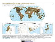
Gridded Population of the World, Version 4 (GPWv4): Administrative Unit Center Points with Population Estimates, Revision 11
National Aeronautics and Space Administration —
The Gridded Population of the World, Version 4 (GPWv4): Administrative Unit Center Points with Population Estimates, Revision 11 consists of UN WPP-adjusted... -
Federal
IPCC Socio-Economic Baseline Dataset
National Aeronautics and Space Administration —
The Intergovernmental Panel on Climate Change (IPCC) Socio-Economic Baseline Dataset consists of population, human development, economic, water resources, land cover,... -
Federal
Global Earthquake Hazard Distribution - Peak Ground Acceleration
National Aeronautics and Space Administration —
The Global Earthquake Hazard Distribution - Peak Ground Acceleration is a 2.5 minute grid of global earthquake hazards developed using Global Seismic Hazard Program... -
Federal
Global Flood Proportional Economic Loss Risk Deciles
National Aeronautics and Space Administration —
The Global Flood Proportional Economic Loss Risk Deciles is a 2.5 minute grid of flood hazard economic loss as proportions of Gross Domestic Product (GDP) per... -
Federal
USGS Global Forest Observations Initiative (GFOI) Burma
National Aeronautics and Space Administration —
The Global Forest Observations Initiative (GFOI) is an initiative of the inter-governmental Group on Earth Observations (GEO) that aims to: foster the sustained... -
Federal
USGS Global Forest Observations Initiative (GFOI) Brazil
National Aeronautics and Space Administration —
The Global Forest Observations Initiative (GFOI) is an initiative of the inter-governmental Group on Earth Observations (GEO) that aims to: foster the sustained... -
Federal
Global Landslide Mortality Risks and Distribution
National Aeronautics and Space Administration —
The Global Landslide Mortality Risks and Distribution is a 2.5 minute grid of global landslide mortality risks. Gridded Population of the World, Version 3 (GPWv3)... -
Federal
West Africa Coastal Vulnerability Mapping: GPW Version 4 Population Density, Preliminary Release 1, 2010
National Aeronautics and Space Administration —
The West Africa Coastal Vulnerability Mapping: GPW Version 4 Population Density, Preliminary Release 1, 2010, represents the number of persons per square kilometer,... -
Federal
Global Rural-Urban Mapping Project, Version 1 (GRUMPv1): Settlement Points
National Aeronautics and Space Administration —
The Global Rural-Urban Mapping Project, Version 1 (GRUMPv1): Settlement Points contains geospatial location for selected settlements. This data set is produced by the... -
Federal
West Africa Coastal Vulnerability Mapping: Subset of OpenStreetMap (OSM) Roads
National Aeronautics and Space Administration —
The West Africa Coastal Vulnerability Mapping: Subset of OpenStreetMap (OSM) Roads data set includes roads within 200 kilometers of the coast and was extracted from... -
Federal
Shared Socioeconomic Pathways (SSPs) Literature Database, v1, 2014-2019
National Aeronautics and Space Administration —
The Shared Socioeconomic Pathways (SSPs) Literature Database, v1, 2014-2019 consists of biographic information, abstracts, and analysis of 1,360 articles published... -
Federal
U.S. Population Grids (Summary File 1), 2000: Alabama, Louisiana, Mississippi and Texas, Alpha Version
National Aeronautics and Space Administration —
The U.S. Population Grids (Summary File 1), 2000: Alabama, Louisiana, Mississippi and Texas, Alpha Version data set contains an ARC/INFO Workspace with grids of... -
Federal
Archive of Census Related Products (ACRP): 1990 Enhanced Migration Files
National Aeronautics and Space Administration —
The 1990 Enhanced Migration Files portion of the Archive of Census Related Products (ACRP) contains migration data derived from the U.S. Census Bureau's Summary Tape... -
Federal
USGS Global Forest Observations Initiative (GFOI) Borneo Island
National Aeronautics and Space Administration —
The Forest Carbon Tracking Task (GEO FCT) has been established to support countries wanting to establish national forest-change, carbon estimation and reporting... -
Federal
Sentinel-3B OLCI Regional Mapped Inland Waters (ILW) Data, version 4
National Aeronautics and Space Administration —
The Inland Waters dataset (ILW) provides data for lakes and other water bodies across the contiguous United States (CONUS) and Alaska. ILW significantly reduces the... -
Federal
Africa Climate Mobility Initiative (ACMI): Internal Migration Projections
National Aeronautics and Space Administration —
The Africa Climate Mobility Initiative (ACMI) Internal Migration Projections project internal migration flows at 5-year intervals from 2020 to 2050 for a combination... -
Federal
Archive of Census Related Products (ACRP): 1980 SAS Transport Files
National Aeronautics and Space Administration —
The 1980 SAS Transport Files portion of the Archive of Census Related Products (ACRP) contains housing and population demographics from the 1980 Summary Tape File... -
Federal
Gridded Population of the World, Version 3 (GPWv3): National Administrative Boundaries
National Aeronautics and Space Administration —
The Gridded Population of the World, Version 3 (GPWv3): National Administrative Boundaries are derived from the land area grid to show the outlines of pixels (cells)...

Official websites use .gov
A
.gov website belongs to an official government
organization in the United States.
Secure .gov websites use HTTPS
A
lock (
) or https:// means you’ve safely connected to
the .gov website. Share sensitive information only on official,
secure websites.