
-
Federal
ABoVE: Gridded 30-m Aboveground Biomass, Shrub Dominance, North Slope, AK, 2007-2016
National Aeronautics and Space Administration —
This dataset includes 30-m gridded estimates of total plant aboveground biomass (AGB), the shrub AGB, and the shrub dominance (shrub/plant AGB) for non-water portions... -
Federal
ABoVE: Vegetation Composition across Fire History Gradients on the Y-K Delta, Alaska
National Aeronautics and Space Administration —
This dataset provides ecological field data that were collected during July 2017 and July 2018 from 43 plots spanning gradients of fire history in the upland tundra... -
Federal
ABoVE: Surface Water Extent, Boreal and Tundra Regions, North America, 1991-2011
National Aeronautics and Space Administration —
This data set provides the location and extent of surface water (open water not including vegetated wetlands) for the entire Boreal and Tundra regions of North... -
Federal
ABoVE: Terrestrial Lidar Scanning Forest-Tundra Ecotone, Brooks Range, Alaska, 2016
National Aeronautics and Space Administration —
This dataset provides terrestrial lidar scanning (TLS) point cloud data collected at 10 research plots along the forest-tundra ecotone (FTE) in the Brooks Range of... -
Federal
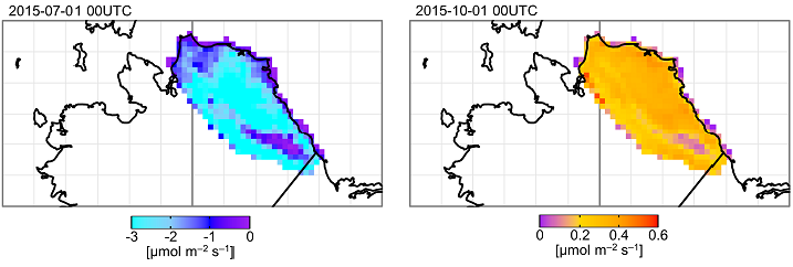
ABoVE: TVPRM Simulated Net Ecosystem Exchange, Alaskan North Slope, 2008-2017
National Aeronautics and Space Administration —
This dataset includes hourly net ecosystem exchange (NEE) simulated by the Tundra Vegetation Photosynthesis and Respiration Model (TVPRM) at 30 km horizontal... -
Federal
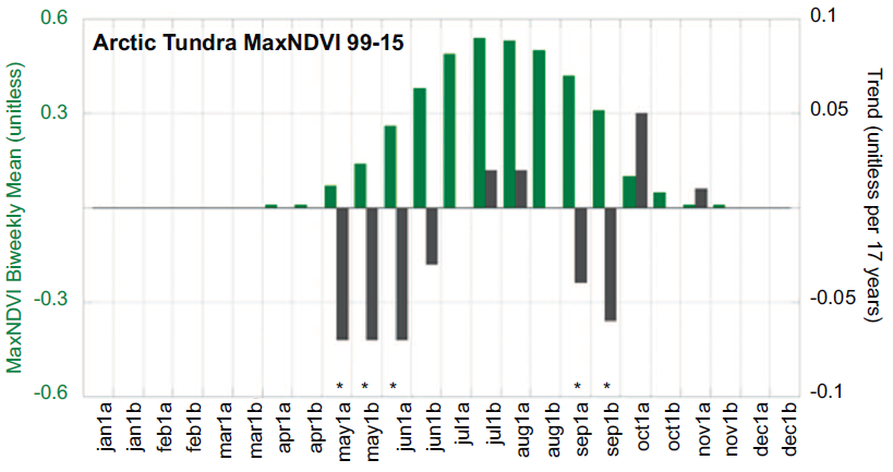
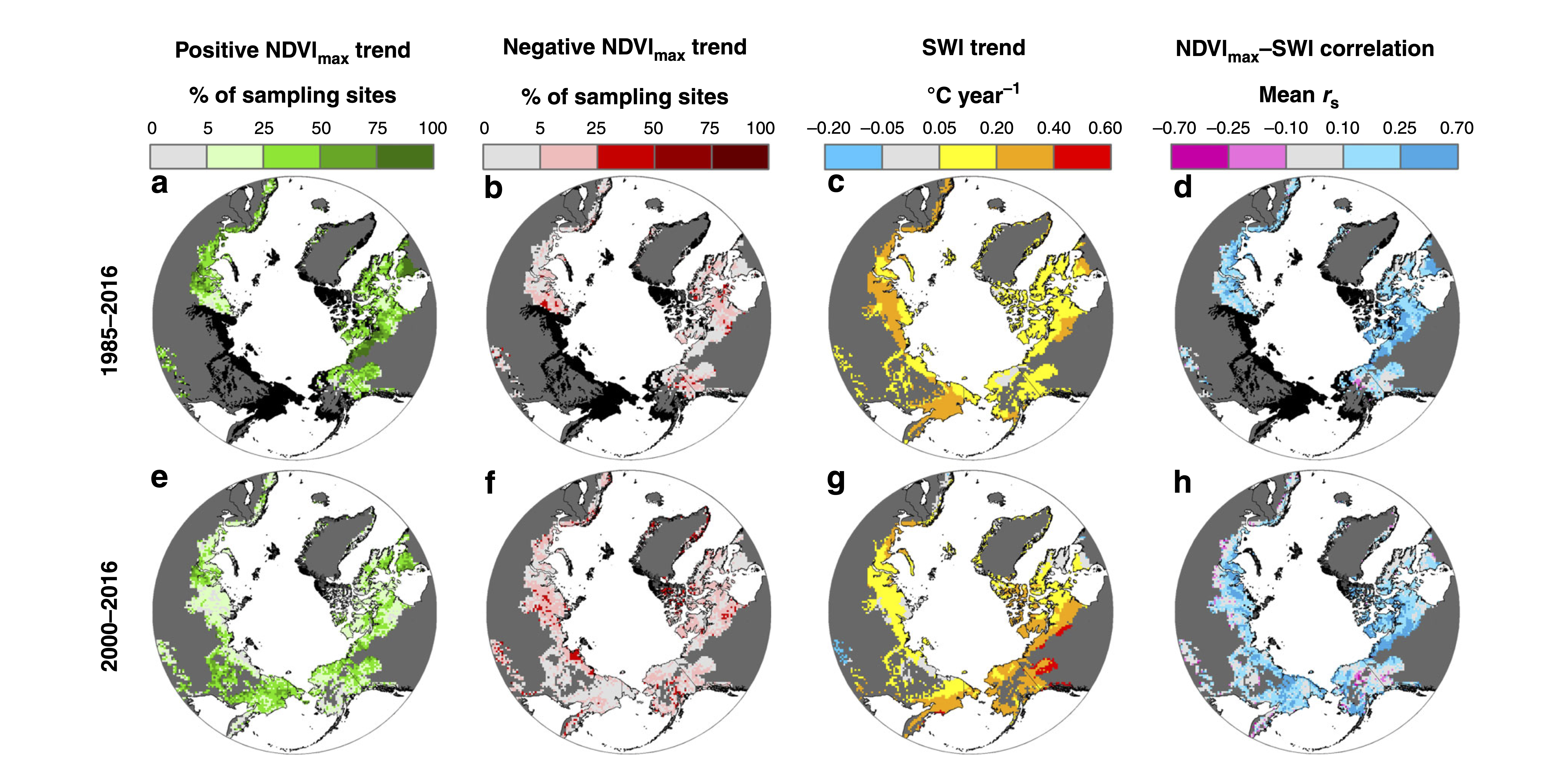
ABoVE: Landsat Tundra Greenness and Summer Air Temperatures, Arctic Tundra, 1985-2016
National Aeronautics and Space Administration —
This dataset provides annual tundra greenness and summer air temperatures at a resolution of 50 km over the pan-Arctic tundra biome above 31.5 degrees over the time... -
Federal
ABoVE: Landsat-derived Annual Dominant Land Cover Across ABoVE Core Domain, 1984-2014
National Aeronautics and Space Administration —
This dataset provides two 30-m resolution time series products of annual land cover classifications over the Arctic Boreal Vulnerability Experiment (ABoVE) core... -
Federal
ABoVE: AVIRIS-NG Imaging Spectroscopy for Alaska, Canada, and Iceland, 2017-2022, V3
National Aeronautics and Space Administration —
This dataset supersedes the previously published ABoVE AVIRIS-NG Level 2 surface reflectance files for 2017-2019 surveys of Alaska and northwestern Canada. It also... -
Federal
Arctic Alaska Vegetation, Geobotanical, Physiographic Maps, 1993-2005
National Aeronautics and Space Administration —
This data set provides the spatial distributions of vegetation types, geobotanical characteristics, and physiographic features for the Arctic tundra region of Alaska... -
Federal
Counts of Birds in Aerial Photos from Fall Waterfowl Surveys, Izembek Lagoon, Alaska, 2017-2019
Department of the Interior —
This dataset includes tables summarizing image information and bird counts from the aerial digital images taken over open water at Izembek Lagoon in Alaska in fall... -
Federal
BigFoot Field Data for North American Sites, 1999-2003
National Aeronautics and Space Administration —
The BigFoot project gathered field data for selected EOS Land Validation Sites in North America from 1999 to 2003. Data collected and derived for varying intervals at... -
Federal
NPP Boreal Forest: Siberian Scots Pine Forests, Russia, 1968-1974, R1
National Aeronautics and Space Administration —
This data set contains two files (comma-separated-value format). One file provides components of net primary productivity, standing biomass, age and stand structure,... -
Federal
NOAA Polar-orbiting Operational Environmental Satellites (POES) Radiometer Data NGDA
National Oceanic and Atmospheric Administration, Department of Commerce —
The Polar-orbiting Operational Environmental Satellite (POES) series offers the advantage of daily global coverage, by making nearly polar orbits 14 times per day... -
Federal
NPP Multi-Biome: PIK Data for Northern Eurasia, 1940-1988 (Based on Bazilevich), R1
National Aeronautics and Space Administration —
There is one comma-separated (.csv) data file and one text (.txt) file (bibliographic information) with this data set. This data set provides above-ground net primary... -
Federal
BigFoot NPP Surfaces for North and South American Sites, 2000-2004
National Aeronautics and Space Administration —
The BigFoot project gathered Net Primary Production (NPP) data for nine EOS Land Validation Sites located from Alaska to Brazil from 2000 to 2004. Each site is... -
Federal
LBA Regional Land Cover from AVHRR, 1-Degree, 1987 (Defries and Townshend)
National Aeronautics and Space Administration —
This data set consists of a subset for the study area of the Large Scale Biosphere-Atmosphere Experiment in Amazonia (LBA) in South America (i.e., longitude 85 deg to... -
State
Ground gravity geophysical survey of the Holitna basin area, Alaska, data compilation
State of Alaska —
Gravity data were acquired at 1,175 stations during the period April 13 to May 3, 1982 by EDCON, Inc. using a helicopter-borne inertial surveying system and LaCoste... -
Federal
ABoVE: Active Layer Soil Characteristics at Selected Sites Across Alaska
National Aeronautics and Space Administration —
This dataset provides soil active layer characteristics from nine locations across Alaska. Soil samples were collected in 2016 except for one site which was sampled... -
Federal
NOAA/WDS Paleoclimatology - Unit Lake, Manitoba Holocene Multiproxy Sediment Data
National Oceanic and Atmospheric Administration, Department of Commerce —
This archived Paleoclimatology Study is available from the NOAA National Centers for Environmental Information (NCEI), under the World Data Service (WDS) for... -
State
Reconnaissance geologic map of the Nome C-3 Quadrangle, Seward Peninsula, Alaska
State of Alaska —
Reconnaissance geologic map of the Nome C-3 Quadrangle, Seward Peninsula, Alaska, Open-File Report 72-322, provides (1:63,360-scale) geologic mapping of parts of the...

Official websites use .gov
A
.gov website belongs to an official government
organization in the United States.
Secure .gov websites use HTTPS
A
lock (
) or https:// means you’ve safely connected to
the .gov website. Share sensitive information only on official,
secure websites.