
-
Federal
CALIPSO Lidar Level 2 Cloud Profile, V4-20
National Aeronautics and Space Administration —
CAL_LID_L2_05kmCPro-Standard-V4-20 is the Cloud-Aerosol Lidar and Infrared Pathfinder Satellite Observations (CALIPSO) Lidar Level 2 Cloud Profile, Version 4-20 data... -
Federal
CERES MODIS Cloud Retrievals in ISCCP-D2like Format Nighttime Aqua FM3 Edition3A
National Aeronautics and Space Administration —
CER_ISCCP-D2like-Nit_Aqua-FM3-MODIS_Edition3A is the Clouds and the Earth's Radiant Energy System (CERES) Moderate Resolution Imaging Spectroradiometer (MODIS) Cloud... -
Federal
SatCORPS CERES GEO Edition 4 Meteosat-8 Northern Hemisphere Version 1.2
National Aeronautics and Space Administration —
CER_GEO_Ed4_MET08_NH_V01.2 is the Satellite Cloud and Radiation Property retrieval System (SatCORPS) Clouds and the Earth's Radiant Energy System (CERES)... -
Federal
NACP LiDAR-based Biomass Estimates, Boreal Forest Biome, North America, 2005-2006
National Aeronautics and Space Administration —
This data set provides estimates of aboveground biomass (AGB) for defined land cover types within World Wildlife Fund (WWF) ecoregions across the boreal biome of... -
Federal
Sentinel-5P TROPOMI Near-Real-Time (NRT) Tropospheric Ozone Column V2 (S5P_L2__O3_TCL_NRT) at GES DISC
National Aeronautics and Space Administration —
The Sentinel-5P TROPOMI Near Real Time (NRT) Tropospheric Ozone Column V2 (S5P_L2__O3_TCL_NRT) at GES DISC is the near real time version of the offline S5P_L2__O3_TCL... -
Federal
Global 30-Year Mean Monthly Climatology, 1901-1960 (New et al.)
National Aeronautics and Space Administration —
This is a data set of 30-year mean monthly surface climate data over global land areas, excluding Antarctica, for the period 1901-1960. The data set is gridded at 0.5... -
Federal
LBA-ECO LC-02 Daily Meteorological Data, Rio Branco, Acre, Brazil: 1970-2001
National Aeronautics and Space Administration —
This data set provides meteorological measurements collected from 3 different meteorological stations within a radius of 8 km in Rio Branco, Acre Brazil, for the... -
Federal
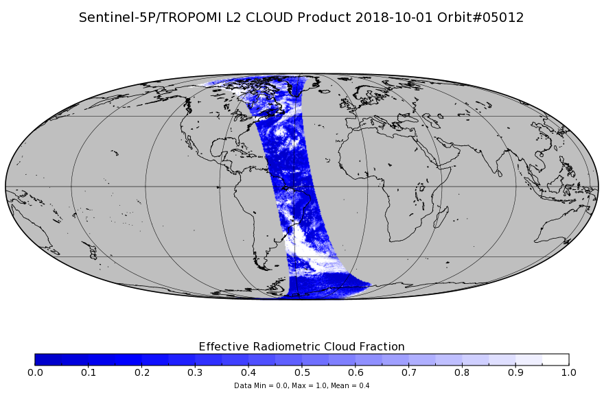
Sentinel-5P TROPOMI Cloud 1-Orbit L2 7km x 3.5km V1 (S5P_L2__CLOUD_) at GES DISC
National Aeronautics and Space Administration —
Starting from August 6th in 2019, Sentinel-5P TROPOMI along-track high spatial resolution (~5.5km at nadir) has been implemented. Starting from July 13th in 2020,... -
Federal
TEMPO gridded cloud fraction and pressure (O2-O2 dimer) V03 (PROVISIONAL)
National Aeronautics and Space Administration —
O2-O2 cloud Level 3 files provide cloud information on a regular grid covering the TEMPO field of regard for nominal TEMPO observations. Level 3 files are derived by... -
Federal
LBA-ECO CD-34 Hyperion 30-m Surface Reflectance, Amazon Basin: 2002-2005
National Aeronautics and Space Administration —
This data set contains 20 multispectral surface reflectance images collected by the EO-1 satellite Hyperion sensor at 30-m resolution and covering the entire Amazon... -
Federal
CERES MODIS Cloud Retrievals in ISCCP-D2like Format Nit Terra FM1 Edition3A
National Aeronautics and Space Administration —
CER_ISCCP-D2like-Nit_Terra-FM1-MODIS_Edition3A is the Clouds and the Earth's Radiant Energy System (CERES) Moderate Resolution Imaging Spectroradiometer (MODIS) Cloud... -
Federal
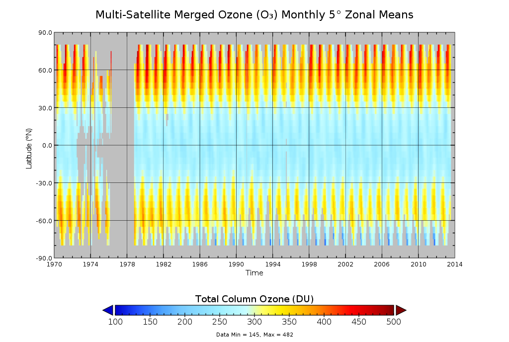
Multi-Satellite Merged Ozone (O3) Profile and Total Column 1 Month Zonal Mean L3 Global 5.0 degree Latitude Zones V1 (MSO3L3zm5) at GES DISC
National Aeronautics and Space Administration —
The merged-satellite Solar Backscattered Ultraviolet (SBUV) Level-3 monthly zonal mean (MZM) product (MSO3L3zm5) contains 1 month zonal means for profile layer and... -
Federal
LBA-ECO LC-21 Brazilian Amazon Fractional Land Cover Images: 1999-2002
National Aeronautics and Space Administration —
This data set provides Landsat Enhanced Thematic Mapper Plus (ETM+) imagery, derived classified land cover products, and cloud-water masks for selected Brazilian... -
Federal
Sentinel-5P TROPOMI SNPP VIIRS cloud product band 6 (NIR detector) 1-Orbit L2 5.5km x 3.5km V2 (S5P_L2__NP_BD6_HiR) at GES DISC
National Aeronautics and Space Administration —
Starting from August 6th in 2019, Sentinel-5P TROPOMI along-track high spatial resolution (~5.5km at nadir) has been implemented. For data before August 6th of 2019,... -
Federal
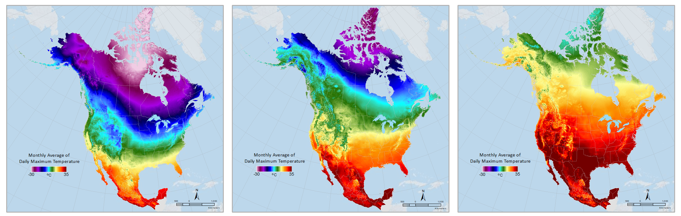
Daymet: Monthly Climate Summaries on a 1-km Grid for North America, Version 4 R1
National Aeronautics and Space Administration —
This dataset provides Daymet Version 4 R1 monthly climate summaries derived from Daymet Version 4 R1 daily data at a 1 km x 1 km spatial resolution for five Daymet... -
Federal
ABoVE: High Resolution Cloud-Free Snow Cover Extent and Snow Depth, Alaska, 2001-2017
National Aeronautics and Space Administration —
This dataset provides estimates of maximum snow cover extent (SCE) and snow depth for each 8-day composite period from 2001 to 2017 at 1 km resolution across Alaska.... -
Federal
BOREAS AFM-08 ECMWF Hourly Surface and Upper Air Data for the SSA and NSA
National Aeronautics and Space Administration —
The BOREAS AFM-08 team focused on modeling efforts to improve the understanding of the diurnal evolution of the convective boundary layer over the boreal forest. This... -
Federal
HRIR/Nimbus-3 Level 1 Meteorological Radiation Data V001 (HRIRN3L1) at GES DISC
National Aeronautics and Space Administration —
HRIRN3L1 is the High Resolution Infrared Radiometer (HRIR) Nimbus-3 Level 1 Meteorological Radiance Data (NMRT) product and contains infrared radiances converted to... -
Federal
LBA-ECO LC-07 Validation Overflight for Amazon Mosaics, Raster, 1999
National Aeronautics and Space Administration —
This data set includes high-resolution geocoded mosaics derived from the Validation Overflight for Amazon Mosaics (VOAM) aerial video surveys as part of the Large-... -
Federal
Sounder SIPS: Suomi NPP CrIMSS Level 3 Comprehensive Quality Control Gridded Daily CLIMCAPS Normal Spectral Resolution V2 (SNDRSNIML3CDCCPN) at GES DISC
National Aeronautics and Space Administration —
WARNING: To users of the derived product “co_mmr_midtrop” (carbon monoxide mass mixing ratio to dry air [kg/kg] at ~500 hPa). This variable has a significant bias due...

Official websites use .gov
A
.gov website belongs to an official government
organization in the United States.
Secure .gov websites use HTTPS
A
lock (
) or https:// means you’ve safely connected to
the .gov website. Share sensitive information only on official,
secure websites.