
-
Federal
SAFARI 2000 LAI and FPAR Measurements at Sua Pan, Botswana, Dry Season 2000
National Aeronautics and Space Administration —
The Multi-angle Imaging SpectroRadiometer (MISR) Validation team was deployed to the Sua Pan salt playa in the Magkadigkadi region of Botswana during the SAFARI 2000... -
Federal
Pre-LBA Rondonia Boundary Layer Experiment (RBLE) Data
National Aeronautics and Space Administration —
The atmospheric boundary layer (ABL) is the layer of air closest to the ground which is directly influenced on a daily basis by the heating and cooling of the earth's... -
Federal
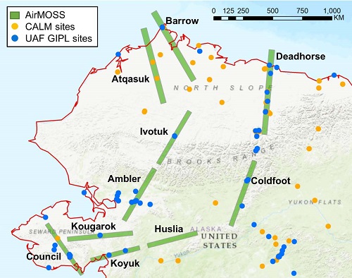
Pre-ABoVE: L1 S-0 Polarimetric Data from AirMOSS P-band SAR, Alaska, 2014-2015
National Aeronautics and Space Administration —
This data set provides level 1 (L1) polarimetric radar backscattering coefficient (sigma-0), multi-look complex, polarimetrically calibrated, and georeferenced data... -
Federal
Polar Radiant Energy in the Far InfraRed Experiment (PREFIRE) Cloud Properties from PREFIRE Satellite 1 R01
National Aeronautics and Space Administration —
Polar Radiant Energy in the Far InfraRed Experiment (PREFIRE) Satellite 1 Cloud Properties (PREFIRE_SAT1_2B-CLD) contains cloud properties derived from data collected... -
Federal
SAFARI 2000 Cloud Physics Lidar (CPL) Quicklook Images and Maps
National Aeronautics and Space Administration —
The effect of clouds and aerosols on regional and global climate is of great importance. Two longstanding elements of the NASA climate and radiation science program... -
Federal
S-MODE Level 3 Shipboard uCTD and EcoCTD Measurements Version 1
National Aeronautics and Space Administration —
This dataset contains shipboard Underway conductivity, temperature, and depth (UCDT) measurements taken during the Sub-Mesoscale Ocean Dynamics Experiment (S-MODE)... -
Federal
S-MODE MASS Level 1 LWIR Version 1
National Aeronautics and Space Administration —
NOTICE: This dataset is currently undergoing maintenance to be repackaged as zip files of flight lines. The file count will decrease dramatically when new zip files... -
Federal
S-MODE L2 Shipboard Bottle Data Version 1
National Aeronautics and Space Administration —
This dataset contains in-situ seawater samples taken during the Sub-Mesoscale Ocean Dynamics Experiment (S-MODE) conducted approximately 300 km offshore of San... -
Federal
SAFARI 2000 Surface Irradiance Measurements, Mongu Tower Site, Zambia, 2000-2002
National Aeronautics and Space Administration —
This data set contains the top-of-canopy irradiance in the shortwave (0.3-2.8 micron) and photosynthetically active radiation (PAR; 0.4-0.7 micron) wavebands... -
Federal
SAFARI 2000 Physical and Chemical Properties of Aerosols, Dry Season 2000
National Aeronautics and Space Administration —
The Southern African Regional Science Initiative 2000 (SAFARI 2000) provided an opportunity to study aerosol particles produced by savanna burning. We used analytical... -
Federal
SAFARI 2000 Organic Soil Carbon and Nitrogen Data (Zinke et al.)
National Aeronautics and Space Administration —
The data set contains a subset of the Worldwide Organic Soil Carbon and Nitrogen (Zinke et al. 1986) data set for southern Africa. The data were obtained from soil... -
Federal
SAFARI 2000 GPCP Daily Precipitation, 1-Deg, 1999-2001
National Aeronautics and Space Administration —
The Global Precipitation Climatology Project (GPCP) is an international project designed to provide improved long-record estimates of precipitation over the globe.... -
Federal
SAFARI 2000 Cloud Absorption Radiometer BRDF, Dry Season 2000
National Aeronautics and Space Administration —
This record links to the web page for the Cloud Absorption Radiometer (CAR) data for the SAFARI 2000 project. Twenty-one flights were undertaken over Southern Africa... -
Federal
SAFARI 2000 Carbon in Live Vegetation, 0.5-Deg (Olson)
National Aeronautics and Space Administration —
This data set is a subset of Olson's Major World Ecosystem Complexes for southern Africa in ASCII GRID and binary image files formats. Olson's Major World Ecosystem... -
Federal
S-MODE MASS Level 1 Visible Imagery Version 1
National Aeronautics and Space Administration —
This dataset contains airborne visible imagery from the Sub-Mesoscale Ocean Dynamics Experiment (S-MODE) during a pilot campaign conducted approximately 300 km... -
Federal
S-MODE Pre-Pilot Ocean Wave Slope from Visible-Band Polarimetry at the Air-Sea Interaction Tower Version 1
National Aeronautics and Space Administration —
These wave slope data from polarimetry described below are considered preliminary and should not be used for any purpose without consulting Chris Zappa... -
Federal
RLC AVHRR-Derived Land Cover, Former Soviet Union, 15-km, 1984-1993
National Aeronautics and Space Administration —
This dataset is a 15-kilometer resolution land cover map for the land area of the Former Soviet Union. There are sixty land cover classes distinguished in this... -
Federal
QuikSCAT Scatterometer Inter-Calibrated ESDR Level 3 Ocean Surface Equivalent Neutral Wind Vectors and Wind Stress Version 1.0
National Aeronautics and Space Administration —
This dataset contains gridded ocean surface wind vectors (equivalent neutral and true 10m) and wind stress vectors derived from satellite-based scatterometer... -
Federal
QuikSCAT Level 2B Ocean Wind Vectors in 12.5km Slice Composites Version 3.1
National Aeronautics and Space Administration —
This dataset contains the latest reprocessed version 3.1 of the Level 2B science-quality ocean surface wind vector retrievals from the QuikSCAT scatterometer. The... -
Federal
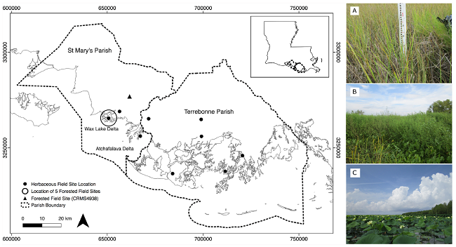
Pre-Delta-X: Vegetation Species, Structure, Aboveground Biomass, MRD, LA, USA, 2015
National Aeronautics and Space Administration —
This dataset provides vegetation species, height, stem density and diameter, and species aboveground biomass (AGB) measurements collected at herbaceous and forested...

Official websites use .gov
A
.gov website belongs to an official government
organization in the United States.
Secure .gov websites use HTTPS
A
lock (
) or https:// means you’ve safely connected to
the .gov website. Share sensitive information only on official,
secure websites.