

1,548 datasets found for "bg真人到底有没有假✅澳门葡京赌场官方网站-网址【079.one】㊙️最火爆PG电子超高爆奖率,注册即送38元.tkpRAhrdgJSpj"
-
Federal
anomaly fans NGDA
Department of the Interior —
Since 1998, geoscientists at the Bureau of Ocean Energy Management (BOEM) have identified and mapped over 31,000 water bottom (seafloor) acoustic amplitude anomalies... -
Federal
Vegetation Taxa List for Rocky Mountain National Park Wetlands Ecological Integrity monitoring (2007-2017).
Department of the Interior —
This table lists all taxa detected at long-term wetland ecological integrity monitoring sites by the NPS Rocky Mountain Network in Rocky Mountain National Park. The... -
State
Erosion Susceptibility Sites
State of Connecticut —
Connecticut Erosion Susceptibility a 1:24,000-scale, polygon feature-based layer that was developed as a predictive tool to show areas most susceptible to terrace... -
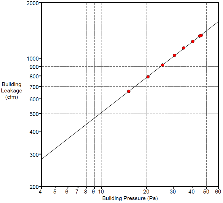
Federal
Field Testing of Compartmentalization Methods for Multifamily Construction - Washington DC
Department of Energy —
BSC TO5 Task 2.1 Field Testing of Compartmentalization Methods for Multifamily Construction - Capitol Heights, MD 20743 A building comprising five vertical townhome... -
Federal
Simbol Materials Lithium Extraction Operating Data From Elmore and Featherstone Geothermal Plants
Department of Energy —
The data provided in this upload is summary data from its Demonstration Plant operation at the geothermal power production plants in the Imperial Valley. The data... -
Federal
Purdue University: Results of B-Value Tests for Rock Saturation
Department of Energy —
This dataset includes an Excel file with the results of B-value tests to determine the magnitude of the back pressure required for full saturation of Sierra White... -
University
Hydrography for Eddy County, New Mexico, 2006se TIGER
Earth Data Analysis Center, University of New Mexico —
The 2006 Second Edition TIGER/Line files are an extract of selected geographic and cartographic information from the Census TIGER database. The geographic coverage... -
Federal
Monitoring of Double-Stud Wall Moisture Conditions in the Northeast
Department of Energy —
BSC TO5 Task 2.2 Monitoring of Double Stud Wall Moisture Conditions in the Northeast Field test data available for wood moisture contents, temperature, and relative... -
Federal
LRIR/Nimbus-6 Level 2 Inverted Profiles of Temperature and Ozone V001 (LRIRN6L2IPAT) at GES DISC
National Aeronautics and Space Administration —
LRIRN6L2IPAT is the Nimbus-6 Limb Radiance Inversion Radiometer (LRIR) Level 2 Inverted Profiles of Temperature and Ozone data product. The product contains daily... -
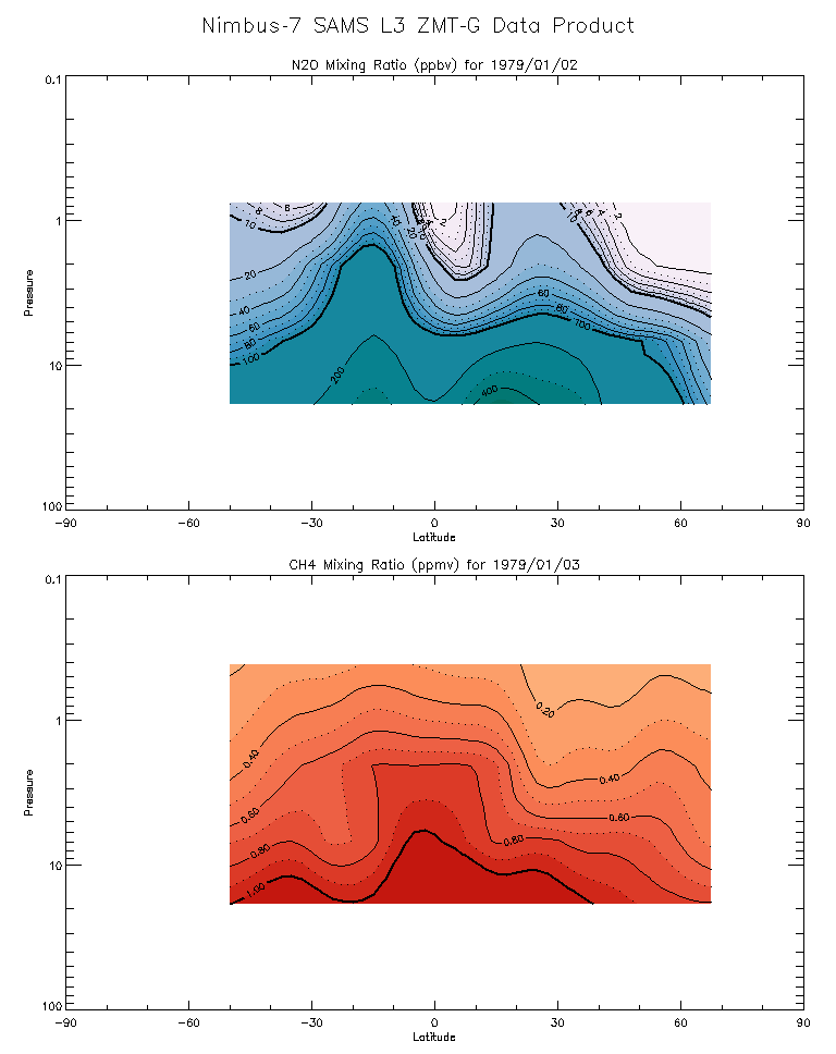
Federal
SAMS/Nimbus-7 Level 3 Zonal Means Composition Data V001 (SAMSN7L3ZMTG) at GES DISC
National Aeronautics and Space Administration —
SAMSN7L3ZMTG is the Nimbus-7 Stratospheric and Mesospheric Sounder (SAMS) Level 3 Zonal Means Composition Data Product. The Earth's surface is divided into 2.5-deg... -
Federal
TIROS-4 Medium-Resolution Scanning Radiometer Level 1 Final Meteorological Radiation Data V001 (TIROS4L1FMRT) at GES DISC
National Aeronautics and Space Administration —
TIROS-4 Medium-Resolution Scanning Radiometer Level 1 Final Meteorological Radiation Data (FMRT) product contains radiances expressed in five infrared/visible... -
Federal
TIROS-3 Medium-Resolution Scanning Radiometer Level 1 Final Meteorological Radiation Data V001 (TIROS3L1FMRT) at GES DISC
National Aeronautics and Space Administration —
TIROS-3 Medium-Resolution Scanning Radiometer Level 1 Final Meteorological Radiation Data (FMRT) product contains radiances expressed in five infrared/visible... -
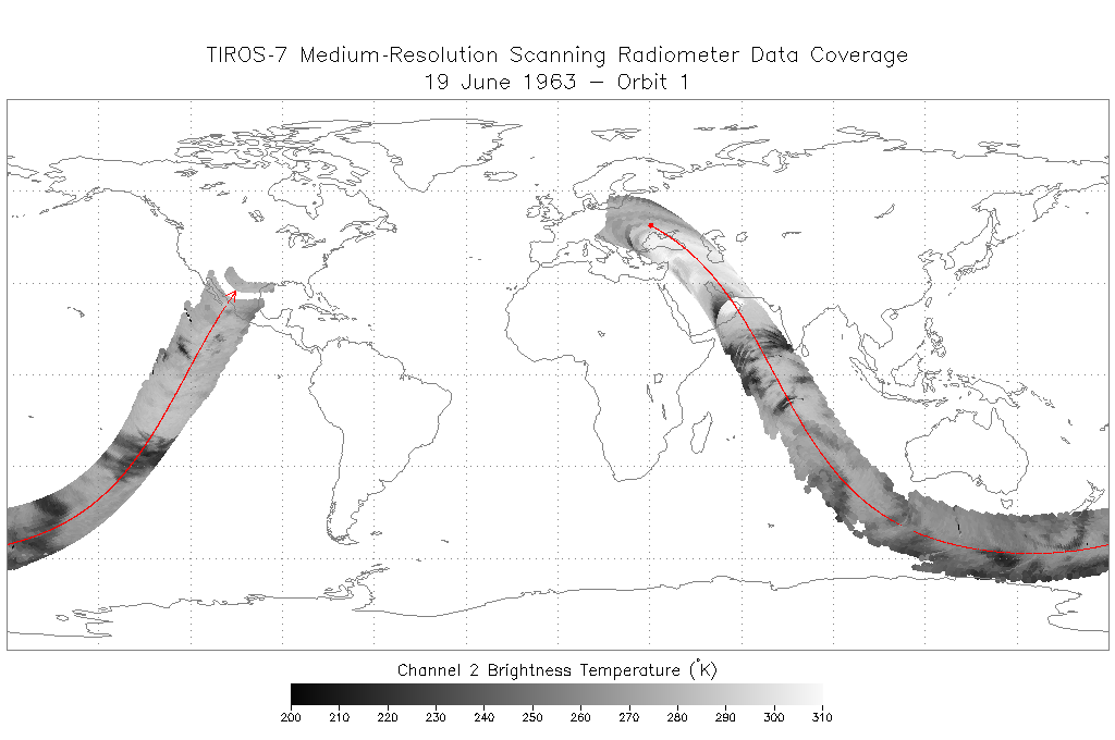
Federal
TIROS-7 Medium-Resolution Scanning Radiometer Level 1 Final Meteorological Radiation Data V001 (TIROS7L1FMRT) at GES DISC
National Aeronautics and Space Administration —
TIROS-7 Medium-Resolution Scanning Radiometer Level 1 Final Meteorological Radiation Data (FMRT) product contains radiances expressed in five infrared/visible... -
State
Los Angeles River Restoration and Access (LLARRA) Water Quality Analysis - Lower Los Angeles River - 2024-2025
State of California —
WCB Grant 2023114: Lower Los Angeles River Restoration and Access: Data includes one (1) year of water quality analysis to inform the design and serve as a baseline... -
Federal
BLM Natl WesternUS FIAT Project Planning Areas 2015 Polygon
Department of the Interior —
This data represents a management strategy of the Fire and Invasives Assessment Tool (FIAT). Project Planning Area (PPA) polygons are part of the FIAT Step 2 process.... -
Federal
VMS Groundfish 2010-2017 (BOEM)
Department of the Interior —
2010-2017 Vessel Monitoring System (VMS) data were used from the NOAA Office of Law Enforcement to create this fishing effort dataset for the U.S. West Coast. The... -
Federal
Generator Fleet Characteristics Model
Department of Commerce —
When run, the GFCM creates tabular and graphical data of the hourly operating status and market outcomes for the generators that make up the electric generating fleet. -
Federal
Sequence-based allelic variations and frequencies for 22 autosomal STR loci in the Lebanese population - Supplementary material
Department of Commerce —
This data repository is meant to provide the supplementary files, tables, and figures included in the peer-reviewed research article entitled: "Sequence-based allelic... -
Federal
Data for "Distributed contactless interconnects for millimeter-wave heterogeneous integration"
Department of Commerce —
Included here are figures and other relevant data from the paper "Distributed contactless interconnects for millimeter-wave heterogeneous integration", submitted to... -
Federal
GIAB Benchmarking of HG002 Assemblies from HPRC Year 1 Bakeoff
Department of Commerce —
The Human Pangenome Reference Consortium (HPRC) tested which combination of current genome sequencing and automated assembly approaches yields the most complete,...
1,548 datasets found for "bg真人到底有没有假✅澳门葡京赌场官方网站-网址【079.one】㊙️最火爆PG电子超高爆奖率,注册即送38元.tkpRAhrdgJSpj"