

148,314 datasets found for "玩龙虎的稳赢方法✅澳门葡京赌场官方网站-网址【079.one】㊙️最火爆PG电子超高爆奖率,注册即送38元.eNisbTDYZYyNmOB"
-
Federal
OCS Aliquot 16ths Polygons – 3rd Division NGDA
Department of the Interior —
This is a national data collection of data resources managed by the Bureau of Ocean Energy Management (BOEM) for the Outer Continental Shelf (OCS). The data... -
Federal
VMS Whiting 2010-2017 (BOEM)
Department of the Interior —
2010-2017 Vessel Monitoring System (VMS) data were used from the NOAA Office of Law Enforcement to create this fishing effort dataset for the U.S. West Coast. The... -
Federal
R1: Oregon Coast: 2000 Aerial Photography of Nesting Seabird Colony Islands for Monitoring Purposes - Selected (Colony) Images Used For Counting, Geospatial Representation
Department of the Interior —
Photography from helicopter taken for the purposes of resource monitoring, specifically seabird colony status and distribution. Oregon Coast aerial and boat based... -
Federal
Vegetation Map of Desert National Wildlife Refuge 2013
Department of the Interior —
This feature class or layer consists of polygon layers that delineate 29 vegetation communities which represent National Vegetation Classification Standard Groups.... -
Federal
seep anomaly confirmed mud volcanoes gas NGDA
Department of the Interior —
Since 1998, geoscientists at the Bureau of Ocean Energy Management (BOEM) have identified and mapped over 31,000 water bottom (seafloor) acoustic amplitude anomalies... -
Federal
anomaly slumps NGDA
Department of the Interior —
Since 1998, geoscientists at the Bureau of Ocean Energy Management (BOEM) have identified and mapped over 31,000 water bottom (seafloor) acoustic amplitude anomalies... -
Federal
plumes EM302 400ft diam NGDA
Department of the Interior —
Since 1998, geoscientists at the Bureau of Ocean Energy Management (BOEM) have identified and mapped over 31,000 water bottom (seafloor) acoustic amplitude anomalies... -
Federal
VMS Bottom Trawl 2010-2017 (BOEM)
Department of the Interior —
2010-2017 Vessel Monitoring System (VMS) data were used from the NOAA Office of Law Enforcement to create this fishing effort dataset for the U.S. West Coast. The... -
Federal
VMS Groundfish 2010-2017 (BOEM)
Department of the Interior —
2010-2017 Vessel Monitoring System (VMS) data were used from the NOAA Office of Law Enforcement to create this fishing effort dataset for the U.S. West Coast. The... -
Federal
VMS Dungeness Crab 2010-2017 (BOEM)
Department of the Interior —
2010-2017 Vessel Monitoring System (VMS) data were used from the NOAA Office of Law Enforcement to create this fishing effort dataset for the U.S. West Coast. The... -
Federal
Little Pend Oreille NWR: Invasive Plant Inventory - Grid-based: Survey Grid (50 x 50 m) for Conducting Field-based Invasive Plant Surveys
Department of the Interior —
This dataset was created to facilitate field-based invasive plant surveys. Each grid-cell constitutes a possible survey area within which a field surveyor documents... -
Federal
Land cover and other geospatial layers created for the paper: Evaluating population connectivity and targeting conservation action for an endangered cat. https://doi.org/10.7944/P92D26LI
Department of the Interior —
Lehnen, S. E., Sternberg, M. A., Swarts, H. M., & Sesnie, S. E. 2021. Evaluating population connectivity and targeting conservation action for an endangered cat.... -
Federal
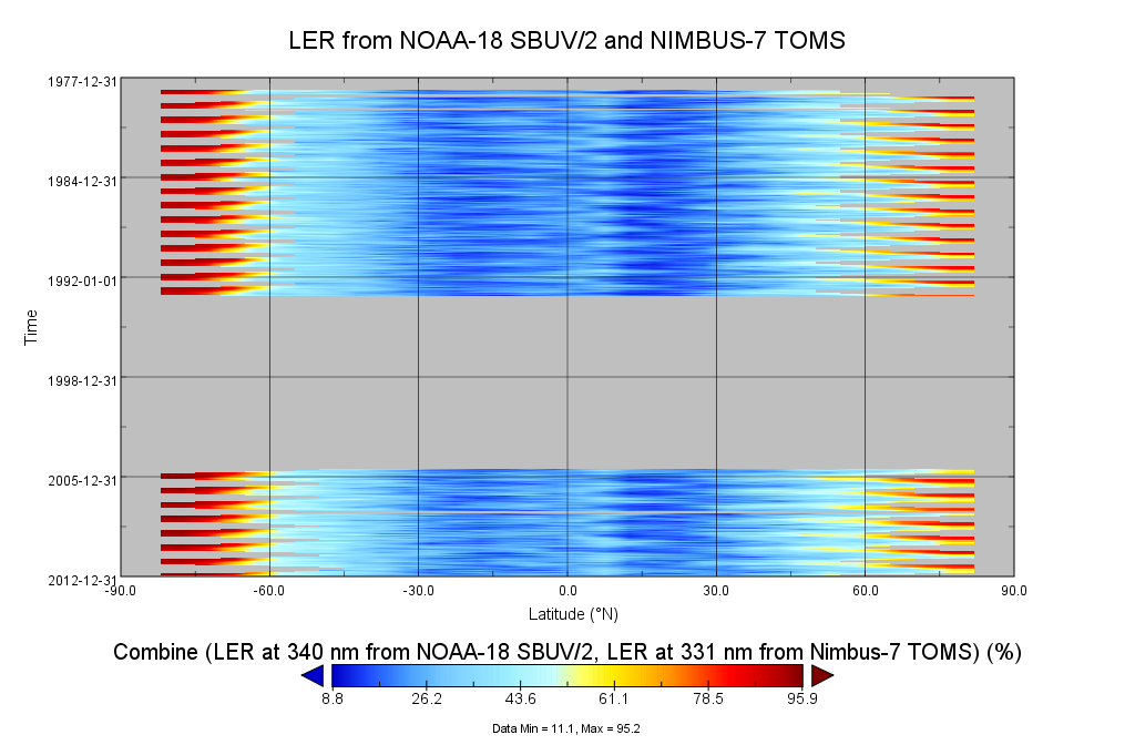
Multi-Satellite Lambertian Equivalent Reflectivity (Local Satellite Time) 1 day L3 Global 5.0deg Lat Zones V1 (MSLERLSTL3zm) at GES DISC
National Aeronautics and Space Administration —
The Multi-Satellite Lambertian Equivalent Reflectivity (Local Satellite Time) 1 day L3 Global 5.0deg Lat Zones data product (MSLERLSTL3zm) is derived from... -
Federal
MACPEX Balloonsondes and Ozonesondes Data
National Aeronautics and Space Administration —
MACPEX_Sondes_Data is the balloonsonde and ozonesonde data collected during the Mid-latitude Airborne Cirrus Properties Experiment (MACPEX). Data were collected by...
148,314 datasets found for "玩龙虎的稳赢方法✅澳门葡京赌场官方网站-网址【079.one】㊙️最火爆PG电子超高爆奖率,注册即送38元.eNisbTDYZYyNmOB"