
-
Federal
OCO-3 Level 2 CO2 prior based on CO2 monthly flask record, global meteorology, and age of air, Retrospective Processing V11r (OCO3_L2_CO2Prior) at GES DISC
National Aeronautics and Space Administration —
Version 11r is the current version of the data set. Older versions will no longer be available and are superseded by Version 11r. The Orbiting Carbon Observatory -3... -
Federal
OCO-2 Level 1A collated, parsed, calibration data V11.2 (OCO2_L1aIn_Pixel) at GES DISC
National Aeronautics and Space Administration —
Version 11.2 is the current version of the data set. Older versions will no longer be available and are superseded by Version 11.2. The Orbiting Carbon Observatory is... -
Federal
OCO-2 Level 1A collated, parsed, calibration data, Retrospective Processing V11r (OCO2_L1aIn_Pixel) at GES DISC
National Aeronautics and Space Administration —
Version 11r is the current version of the data set. Older versions will no longer be available and are superseded by Version 11r. The Orbiting Carbon Observatory is... -
Federal
Ocean color calibration and validation measurements off the New Jersey and New York coasts
National Aeronautics and Space Administration —
Measurements made off the New Jersey and New York coasts between 2005 and 2009. -
Federal
MODIS/Terra+Aqua BRDF/Albedo Black Sky Albedo Band6 Daily L3 Global 30ArcSec CMG V061
National Aeronautics and Space Administration —
The MCD43D47 Version 6.1 Bidirectional Reflectance Distribution Function and Albedo (BRDF/Albedo) Black-Sky Albedo dataset is produced daily using 16 days of Terra... -
Federal
OCO-3 Level 1A collated, parsed, science or calibration data V11 (OCO3_L1aIn_Sample) at GES DISC
National Aeronautics and Space Administration —
Version 11 is the current version of the data set. Older versions will no longer be available and are superseded by Version 11. The Orbiting Carbon Observatory is the... -
Federal
NASA MEASURES Precipitation Ensemble based on TMI TRMM NASA PPS L1C V05 Tbs 1-orbit L2 Swath 5x5km V1 (PRECIP_TMI_TRMM) at GES DISC
National Aeronautics and Space Administration —
The data presented in this level 2 orbital product are rain rate estimates expressed as mm/hour determined from brightness temperatures (Tbs) obtained from the... -
Federal
MODIS/Terra+Aqua BRDF/Albedo Black Sky Albedo Band5 Daily L3 Global 30ArcSec CMG V061
National Aeronautics and Space Administration —
The MCD43D46 Version 6.1 Bidirectional Reflectance Distribution Function and Albedo (BRDF/Albedo) Black-Sky Albedo dataset is produced daily using 16 days of Terra... -
Federal
MLS/Aura Near-Real-Time L2 Sulfur Dioxide (SO2) Mixing Ratio V005 (ML2SO2_NRT) at GES DISC
National Aeronautics and Space Administration —
ML2SO2_NRT is the EOS Aura Microwave Limb Sounder (MLS) Near-Real-Time (NRT) product for sulfur dioxide (SO2). This product contains SO2 profiles derived from the 190... -
Federal
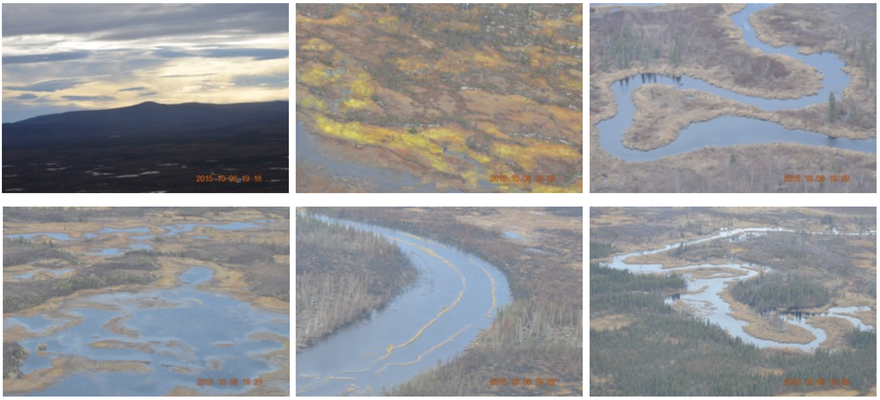
CARVE: In-flight Photos from the CARVE Aircraft, Alaska, 2013-2015
National Aeronautics and Space Administration —
This dataset contains photos taken by scientists aboard the CARVE aircraft during airborne campaigns over the Alaskan and Canadian Arctic for the Carbon in Arctic... -
Federal
VOYAGER 1 SOLAR WIND PLS 1 HOUR AVERAGES V1.0
National Aeronautics and Space Administration —
Voyager 1 plasma data of the solar wind, 1 hour averages. -
Federal
AIRS/Aqua L1B Near Real Time (NRT) Infrared (IR) geolocated and calibrated radiances V005 (AIRIBRAD_NRT) at GES DISC
National Aeronautics and Space Administration —
WARNING: On 2021/09/23 the EOS Aqua executed a Deep Space Maneuver (DSM). In the DSM, the spacecraft is turned such that the normal Earth field of regard is deep... -
Federal
CERES ERBE-like Gridded Instantaneous TOA Fluxes Terra Crosstrack Edition4
National Aeronautics and Space Administration —
CER_ES9_Terra-Xtrk_Edition4 is the Clouds and the Earth's Radiant Energy System (CERES) Earth Radiation Budget Experiment (ERBE)-like Gridded Instantaneous Top-of-... -
Federal
CMS: LiDAR-derived Estimates of Aboveground Biomass at Four Forested Sites, USA
National Aeronautics and Space Administration —
These data consist of high-resolution maps of aboveground biomass at four forested sites in the US: Garcia River Tract in California, Anne Arundel and Howard Counties... -
Federal
BARREL 1T X-ray Spectrometer (MSPC) Bremsstrahlung X-ray Spectrum Medium Time Resolution, Level 2, 4 s Data
National Aeronautics and Space Administration —
MSPC: 48 channels of medium time resolution, 4 s, Bremsstrahlung X-ray spectra detected with a NaI Scintillator. The nominal energy range covered by the 48 channels... -
Federal
VIIRS/NPP BRDF/Albedo Parameter 1 DNB Daily L3 Global 30 ArcSec CMG V002
National Aeronautics and Space Administration —
The NASA/NOAA Suomi National Polar-orbiting Partnership (Suomi NPP) Visible Infrared Imaging Radiometer Suite (VIIRS) Bidirectional Reflectance Distribution Function... -
Federal
VIIRS/NPP BRDF/Albedo Parameter 1 Band M5 Daily L3 Global 30 ArcSec CMG V001
National Aeronautics and Space Administration —
The VNP43D13 Version 1 data product was decommissioned on July 31, 2025. Users are encouraged to use theFederalVIIRS/NPP BRDF/Albedo Parameter 1 Band M8 Daily L3 Global 30 ArcSec CMG V002
National Aeronautics and Space Administration —
The NASA/NOAA Suomi National Polar-orbiting Partnership (Suomi NPP) Visible Infrared Imaging Radiometer Suite (VIIRS) Bidirectional Reflectance Distribution Function...FederalMARS EXPRESS MARS PFS EDR THIRD EXTENSION MISSION DATA V1.0
National Aeronautics and Space Administration —
The Mars Express PFS data set contains raw (CODMAC Level 2) measurements from the Planetary Fourier Spectrometer collected during the first extension Mars orbit phases.FederalCATS-ISS Level 1B Day Mode 7.2 Version 3-00
National Aeronautics and Space Administration —
CATS-ISS_L1B_D-M7.2-V3-00 is the Cloud-Aerosol Transport System (CATS) International Space Station (ISS) Level 1B Day Mode 7.2 Version 3-00 data product. This...14,469 datasets found for "JSON"

Official websites use .gov
A
.gov website belongs to an official government
organization in the United States.
Secure .gov websites use HTTPS
A
lock (
) or https:// means you’ve safely connected to
the .gov website. Share sensitive information only on official,
secure websites.