

195 datasets found
-
City
Fiber Priority Area
City of Bloomington —
Delineates the boundary that will be used during the Bloomington municipal fiber build-out as a priority for the purposes of digital equity. -
City
Bloomington 2-Mile Fringe
City of Bloomington —
This map data layer represents the former 2 Mile Fringe for the City of Bloomington, Indiana. This area was establish by an inter-local agreement between the City of... -
Federal
HHS COVID-19 Small Area Estimations Survey - Primary Vaccine Series - Wave 07
U.S. Department of Health & Human Services —
The goal of the Monthly Outcome Survey (MOS) Small Area Estimations (SAE) is to generate estimates of the proportions of adults, by county and month, who were in the... -
City
Tax Increment Finance District
City of Bloomington —
This map data layer represents the boundaries of the Bloomington Tax Increment Financing (TIF) Districts; the North Kinser-Prow Road TIF and the Bloomington... -
State
Spatial and Economic Human Uses, California South Coast MPA Baseline Study, 1992 to 2012
State of California —
This study addresses the South Coast MPA Baseline Program objectives by describing human use patterns across the study region and establishing initial data points for... -
Federal
Gazetteer of Planetary Nomenclature: Moon: 1:10 million-scale Shaded Relief and Color-coded Topography: South Pole
National Aeronautics and Space Administration —
These lunar maps display the four different areas of the moon with color-coded topography in low and high resolution approved by the International Astronomical Union... -
Federal
Tularosa Basin Play Fairway Analysis: Partial Basin and Range Heat and Zones of Critical Stress Maps
Department of Energy —
Interpolated maps of heat flow, temperature gradient, and quartz geothermometers are included as TIF files. Zones of critical stress map is also included as a TIF... -
Federal
SubTER ZTEM (Z-Axis Tipper Electromagnetic) Survey Results, Mineral Mountains Area, Utah
Department of Energy —
This data was acquired as part of the Subsurface Science, Technology and Engineering Research, and Development (SubTER) Crosscut which is a collaboration across the... -
Federal
HHS COVID-19 Small Area Estimations Survey - Monovalent Booster Audience - Wave 18
U.S. Department of Health & Human Services —
The goal of the Monthly Outcome Survey (MOS) Small Area Estimations (SAE) are to generate estimates of the proportions of adults, by county and month, who were in the... -
Federal
PDS Planetary Maps API
National Aeronautics and Space Administration —
We are developing a set of NASA Extensions to the Google Maps API—and soon to other frameworks such as OpenLayers as well—that will make these platforms more useful... -
Federal
HHS COVID-19 Small Area Estimations Survey - Primary Vaccine Series - Wave 11
U.S. Department of Health & Human Services —
The goal of the Monthly Outcome Survey (MOS) Small Area Estimations (SAE) is to generate estimates of the proportions of adults, by county and month, who were in the... -
City
Address Points Bloomington
City of Bloomington —
This layer represents address point locations within the City of Bloomington, Indiana sourced from the City's Master Address Database. It includes street, subunit,... -
Federal
HHS COVID-19 Small Area Estimations Survey - Primary Vaccine Series - Wave 25
U.S. Department of Health & Human Services —
The goal of the Monthly Outcome Survey (MOS) Small Area Estimations (SAE) is to generate estimates of the proportions of adults, by county and month, who were in the... -
County
King County Voting Districts (Geo Data)
King County, Washington —
Voting Districts in King County, Washington (spatial) -
Federal
GIBS Tiled Web Mapping Service (TWMS)
National Aeronautics and Space Administration —
The TWMS specification is a custom extension to the OGS WMS standard developed by the NASA Jet Propulsion Laboratory. Similar to the OGC WMTS specification, TWMS... -
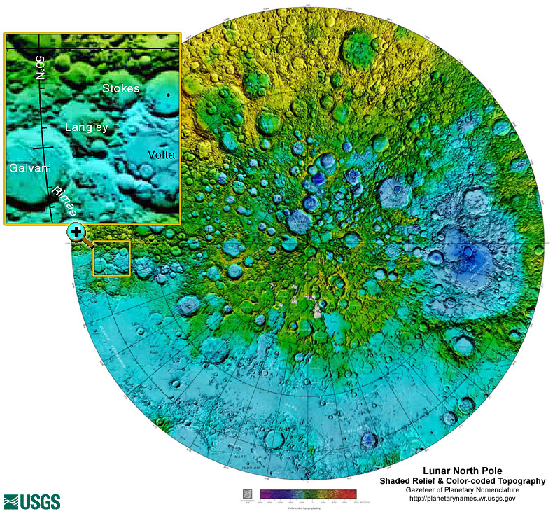
Federal
Gazetteer of Planetary Nomenclature: Moon: 1:10 million-scale Shaded Relief and Color-coded Topography: North Pole
National Aeronautics and Space Administration —
These lunar maps display the four different areas of the moon with color-coded topography in low and high resolution approved by the International Astronomical Union... -
Federal
HHS COVID-19 Small Area Estimations Survey - Primary Vaccine Series - Wave 14
U.S. Department of Health & Human Services —
The goal of the Monthly Outcome Survey (MOS) Small Area Estimations (SAE) is to generate estimates of the proportions of adults, by county and month, who were in the... -
City
Proposed Annexation 2021
City of Bloomington —
Proposed 2021 annexation areas for the City of Bloomington used to define and display areas under consideration for annexation. -
City
Multiuse Sidepaths
City of Bloomington —
This map layer represents the multiuse pedestrian paths in and around the City of Bloomington, Bloomington. This paths features captures pedestrian features managed... -
City
Waterlines
City of Bloomington —
This map data layer represents area hydrology waterbody features for the City of Bloomington, Indiana. This includes lakes, ponds, and other water area features.
195 datasets found