
-
Federal
ABoVE: Post-Fire and Unburned Field Site Data, Anaktuvuk River Fire Area, 2008-2017
National Aeronautics and Space Administration —
This dataset includes field measurements from 26 burned and unburned transects established in 2008 in the region of the Anaktuvuk River tundra fire on the Arctic... -
Federal
CYGNSS Level 3 Science Data Record Version 3.2
National Aeronautics and Space Administration —
This dataset contains the version 3.2 CYGNSS level 3 science data record which provides the average wind speed and mean square slope (MSS) on a 0.2x0.2 degree... -
Federal
PSP FIELDS Digital Fields Board (DFB) AC-coupled Differential Voltage, V1-V2, V3-V4 Antennae, Dipole Mode, Cross Spectra, High Gain, Sensor coordinates, Level 2 (L2), 0.873813 s Data
National Aeronautics and Space Administration —
PSP FIELDS Digital Fields Board (DFB), XXX ⨯ YYY cross spectra data:The DFB is the low frequency, less than 75 kHz, component of the FIELDS experiment on the Parker... -
Federal
CYGNSS Level 2 Science Data Record Version 2.1
National Aeronautics and Space Administration —
This dataset contains the Version 2.1 CYGNSS Level 2 Science Data Record which provides the time-tagged and geolocated average wind speed (m/s) and mean square slope... -
Federal
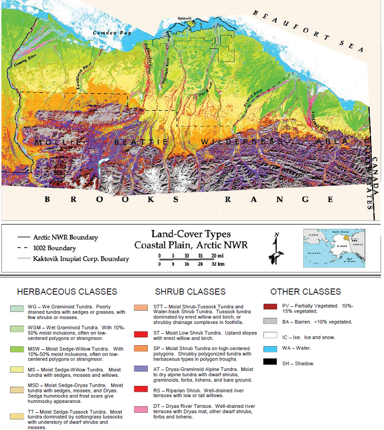
Land Cover and Vegetation Map, Arctic National Wildlife Refuge
National Aeronautics and Space Administration —
This data set provides a landcover map with 16 landcover classes for the northern coastal plain of the the Arctic National Wildlife Refuge (ANWR) on the North Slope... -
Federal
Ensemble X-Ray Variability of AGN in 2XMMi-DR3
National Aeronautics and Space Administration —
The X-ray variability of active galactic nuclei (AGN) has been most often investigated with studies of individual, nearby sources, and only a few ensemble analyses... -
Federal
UV/X-Ray Data for M Dwarfs Within 10 Parsecs
National Aeronautics and Space Administration —
M dwarfs are the most numerous stars in the galaxy. They are characterized by strong magnetic activity. The ensuing high-energy emission is crucial for the evolution... -
Federal
Standing Crop & Nitrogen Content (FIFE)
National Aeronautics and Space Administration —
The FIFE Standing Crop and Nitrogen Content Data Set contains biomass and nitrogen concentration data for live and dead above-ground plant material collected along... -
Federal
Second INTEGRAL AGN Catalog
National Aeronautics and Space Administration —
The INTEGRAL mission provides a large data set for studying the hard X-ray properties of AGN and allows testing the unified scheme for AGN. This table contains some... -
Federal
CHAMP/SDSS Nearby Low-Luminosity AGN Catalog
National Aeronautics and Space Administration —
The combination of the Sloan Digital Sky Survey (SDSS) and the Chandra Multiwavelength Project (ChaMP; Green et al. 2004, ApJS, 150, 43) currently offers the largest... -
Federal
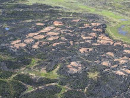
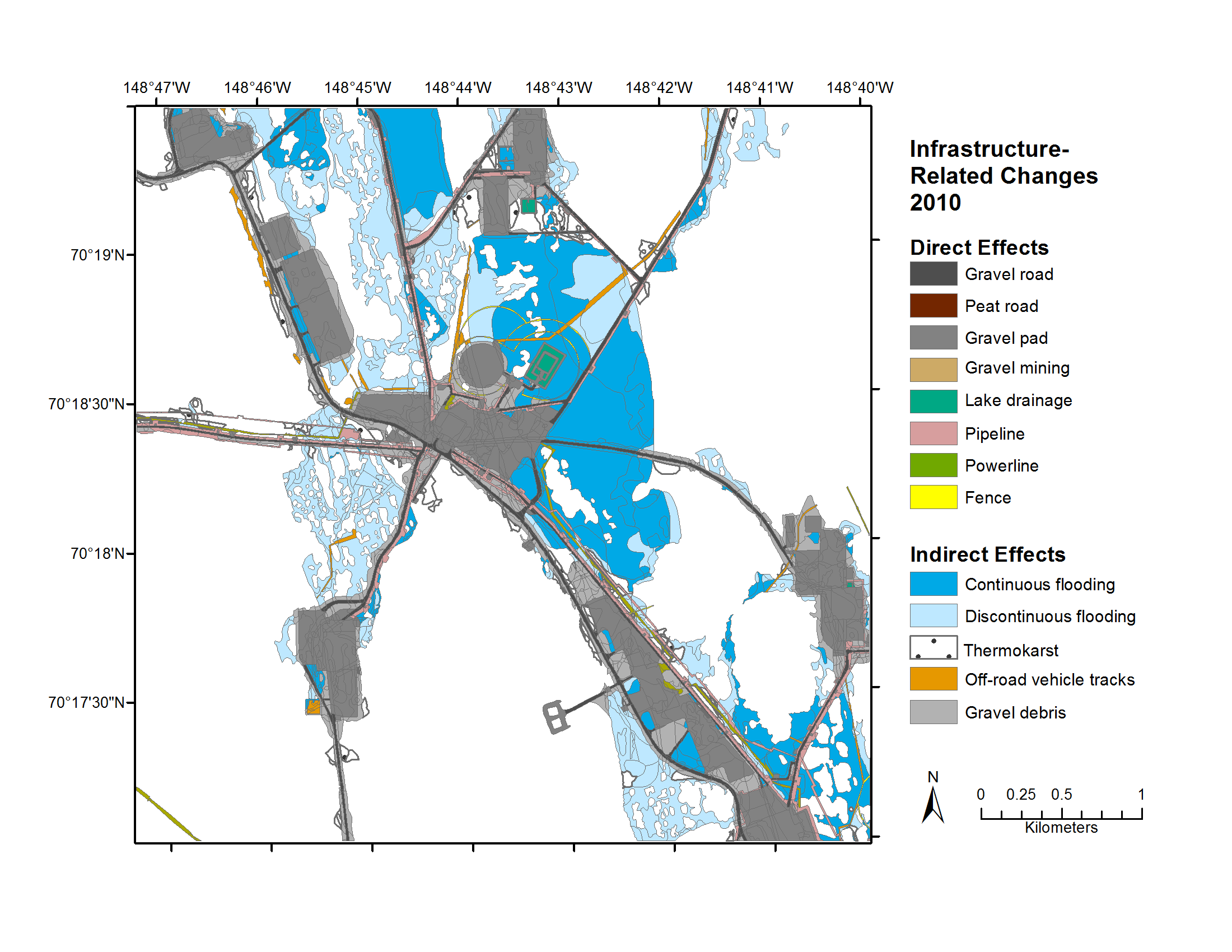
Geobotanical and Impact Map Collection for Prudhoe Bay Oilfield, Alaska, 1972-2010
National Aeronautics and Space Administration —
This data set provides a collection of maps of geoecological characteristics of areas within the Beechey Point quadrangle near Prudhoe Bay on the North slope of... -
Federal
PSP FIELDS Digital Fields Board (DFB) DC-coupled Searchcoil Magnetometer, SCM, Spectra, Low Frequency, High Gain, w-component, Sensor coordinates, Level 2 (L2), 6.99054 s Data
National Aeronautics and Space Administration —
PSP FIELDS Digital Fields Board, DFB, SCMwlfhg data:The DFB is the low frequency, less than 75 kHz, component of the FIELDS experiment on the Parker Solar Probe... -
Federal
CYGNSS Level 3 Science Data Record Version 3.1
National Aeronautics and Space Administration —
This dataset contains the Version 3.1 CYGNSS Level 3 Science Data Record which provides the average wind speed and mean square slope (MSS) on a 0.2x0.2 degree... -
Federal
CYGNSS Level 1 Climate Data Record Version 1.2
National Aeronautics and Space Administration —
This Level 1 (L1) dataset contains the Version 1.2 Climate Data Record (CDR) of the geo-located Delay Doppler Maps (DDMs) calibrated into Power Received (Watts) and... -
Federal
LBA-ECO CD-08 Tree Diameter Measurements, Jacaranda Plots, Manaus, Brazil: 1999-2001
National Aeronautics and Space Administration —
This data set provides diameter at breast height (DBH) measurements made of trees in a dense terra-firme tropical moist forest at the ZF-2 Experimental Station, 90 km... -
Federal
Star-Forming Galaxies High-Mass X-Ray Binaries Catalog
National Aeronautics and Space Administration —
Based on a homogeneous set of X-ray, infrared and ultraviolet observations from Chandra, Spitzer, GALEX and 2MASS archives, the authors studied populations of high-... -
Federal
CYGNSS Level 1 Climate Data Record Version 1.0
National Aeronautics and Space Administration —
This Level 1 (L1) dataset contains the Version 1.0 Climate Data Record (CDR) of the geo-located Delay Doppler Maps (DDMs) calibrated into Power Received (Watts) and... -
Federal
SWOT Level 2 Water Mask Pixel Cloud Auxiliary Data Product, Version D
National Aeronautics and Space Administration —
The SWOT Level 2 Water Mask Pixel Cloud Auxiliary Data Product (SWOT_L2_HR_PIXCVec_D) provides per-feature attributes for surface water bodies identified from the Ka-... -
Federal
PSP FIELDS Digital Fields Board (DFB) AC-coupled Searchcoil Magnetometer, SCM, Spectra, Low Frequency, High Gain, v-component, Sensor coordinates, Level 2 (L2), 0.873813 s Data
National Aeronautics and Space Administration —
PSP FIELDS Digital Fields Board, DFB, SCMvlfhg data:The DFB is the low frequency, less than 75 kHz, component of the FIELDS experiment on the Parker Solar Probe... -
Federal
CYGNSS Level 2 Science Data Record Version 3.0
National Aeronautics and Space Administration —
This dataset contains the Version 3.0 CYGNSS Level 2 Science Data Record which provides the time-tagged and geolocated average wind speed (m/s) and mean square slope...

Official websites use .gov
A
.gov website belongs to an official government
organization in the United States.
Secure .gov websites use HTTPS
A
lock (
) or https:// means you’ve safely connected to
the .gov website. Share sensitive information only on official,
secure websites.