
-
Federal
MRIR/Nimbus-3 Level 1 Meteorological Radiation Data V001 (MRIRN3L1) at GES DISC
National Aeronautics and Space Administration —
MRIRN3L1 is the Nimbus-3 Medium-Resolution Infrared Radiometer (MRIR) Level 1 Meteorological Radiance Data product and contain radiances expressed as equivalent... -
Federal
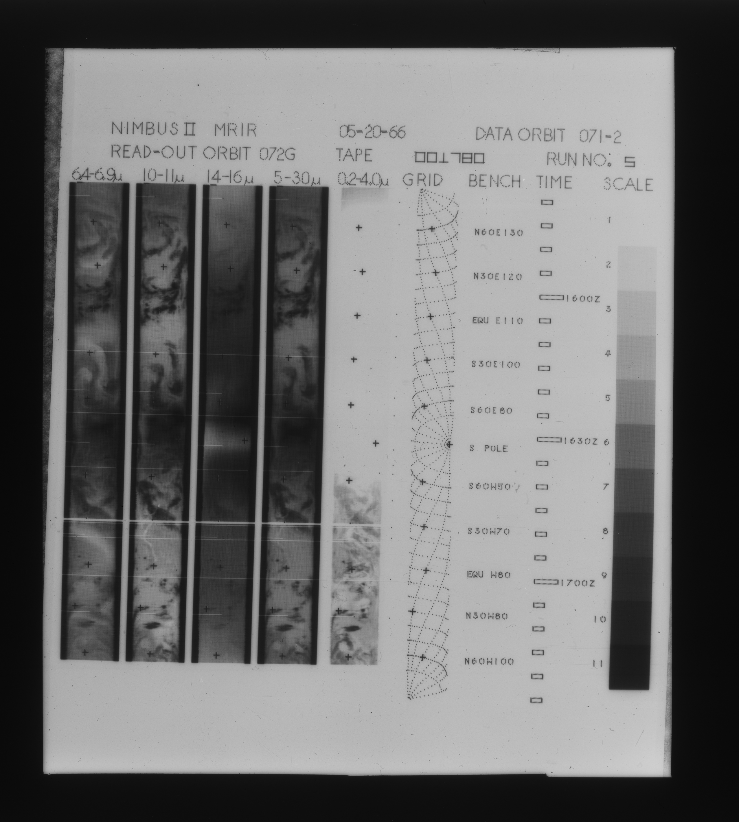
MRIR/Nimbus-2 Level 1 Meteorological Radiation Data V001 (MRIRN2L1) at GES DISC
National Aeronautics and Space Administration —
The Nimbus 2 Medium Resolution Infrared Radiometer (MRIR) was designed to measure electromagnetic radiation emitted and reflected from the earth and its atmosphere at... -
Federal
CALIPSO Lidar Level 3 Tropospheric Aerosol Profiles, All Sky Data, Standard V4-20
National Aeronautics and Space Administration —
CAL_LID_L3_Tropospheric_APro_AllSky-Standard-V4-20 is the Cloud-Aerosol Lidar and Infrared Pathfinder Satellite Observation (CALIPSO) Lidar Level 3 Tropospheric... -
Federal
OPERA Land Surface Disturbance Alert from Harmonized Landsat Sentinel-2 product (Version 1)
National Aeronautics and Space Administration —
The Observational Products for End-Users from Remote Sensing Analysis (OPERA) Land Surface Disturbance Alert from Harmonized Landsat Sentinel-2 (HLS) product Version... -
Federal
Sounder SIPS: Suomi NPP CrIMSS Level 2 CLIMCAPS Normal Spectral Resolution: Atmosphere cloud and surface geophysical state V2 (SNDRSNIML2CCPRETN) at GES DISC
National Aeronautics and Space Administration —
WARNING: To users of the derived product “co_mmr_midtrop” (carbon monoxide mass mixing ratio to dry air [kg/kg] at ~500 hPa). This variable has a significant bias due... -
Federal
LBA-ECO LC-39 Modeled Carbon Flux from Deforestation, Mato Grosso, Brazil: 2000-2006
National Aeronautics and Space Administration —
This data set contains modeled estimates of carbon flux, biomass, and annual burning emissions across the Brazilian state of Mato Grosso from 2000-2006. The model,... -
Federal
CALIPSO Wide Field Camera Level 1B 125m Native Science data, Validated Stage 1 V3-02
National Aeronautics and Space Administration —
CAL_WFC_L1_125m-ValStage1-V3-02 data are Cloud-Aerosol Lidar and Infrared Pathfinder Satellite Observation (CALIPSO) Wide Field Camera (WFC) Level 1B 125 m Native... -
Federal
LBA-ECO LC-10 Landsat TM Data for Legal Amazon: 1986-1994
National Aeronautics and Space Administration —
This data set includes Landsat TM scenes from across the Legal Amazon region. A single image is provided for each spatial tile, representing the most cloud-free... -
Federal
LBA-ECO LC-10 Orthorectified Landsat ETM+ Data for Legal Amazon: 1999-2001
National Aeronautics and Space Administration —
This data set includes orthorectified Landsat ETM+ scenes across the Legal Amazon region. At least one scene is provided for each spatial tile, representing the most... -
Federal
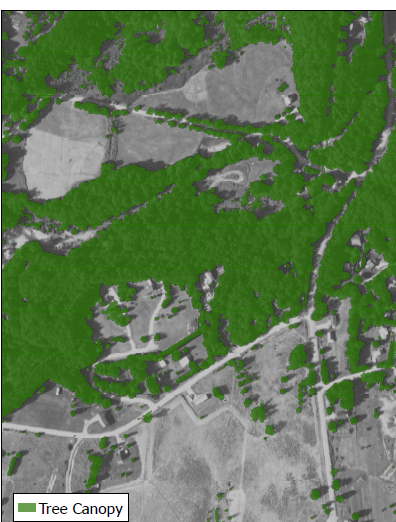
CMS: Tree Canopy Cover at 0.5-meter resolution, Vermont, 2016
National Aeronautics and Space Administration —
This dataset contains estimates of tree canopy cover presence at high resolution (0.5m) across the state of Vermont for 2016 in Cloud-Optimized GeoTIFF (*.tif)... -
Federal
BOREAS/AES MARS-II 15-minute Surface Meteorological Data: 1994
National Aeronautics and Space Administration —
Canadian AES personnel collected several data sets related to surface and atmospheric meteorological conditions over the BOREAS region. This data set contains... -
Federal
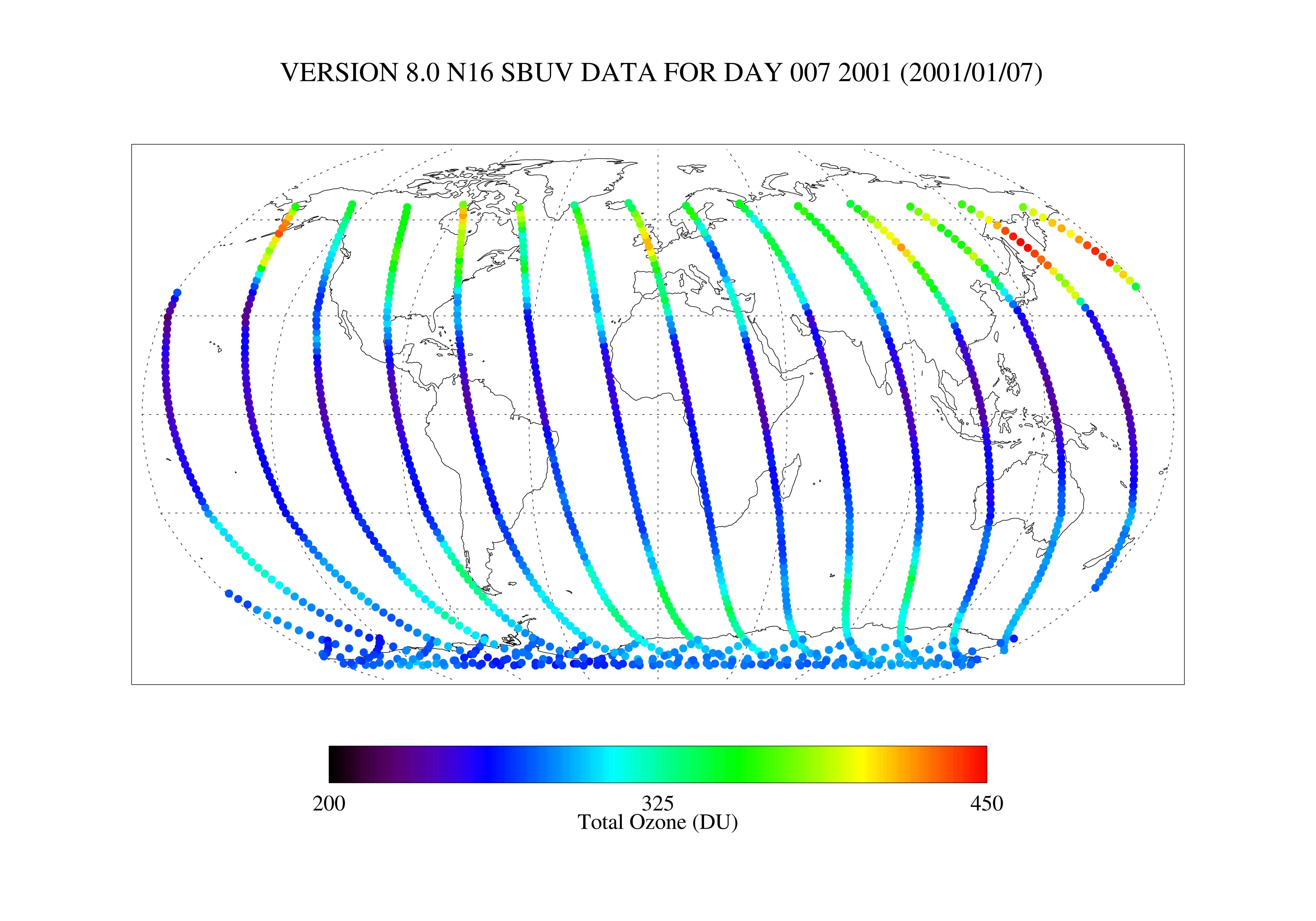
SBUV2/NOAA-16 Level 2 Daily Ozone Profile and Total Column from CD-ROM V008 (SBUV2N16O3) at GES DISC
National Aeronautics and Space Administration —
The version 8 SBUV/2 NOAA-16 ozone data were first released at the 2004 Quadrennial Ozone Symposium on DVD. The DVD contained all of the SBUV/2 data from NOAA-9,... -
Federal
SE-590 Ground Data: UNL (FIFE)
National Aeronautics and Space Administration —
The SE-590 Reflectance Factors and Radiances from UNL Data Set contains surface reflectance and viewing angle data that was collected at three sites within the FIFE... -
Federal
ISLSCP II Global Precipitation Climatology Project Version 2, Monthly Precipitation
National Aeronautics and Space Administration —
The Global Precipitation Climatology Project (GPCP) Version 2 data set includes global, monthly precipitation rates and associated random errors (RMSE), and a monthly... -
Federal
OMI/Aura Level 2 Sulphur Dioxide (SO2) Trace Gas Column Data 1-Orbit Subset and Collocated Swath along CloudSat V003 (OMSO2_CPR) at GES DISC
National Aeronautics and Space Administration —
This is a CloudSat-collocated subset of the original product OMSO2, for the purposes of the A-Train mission. The goal of the subset is to select and return OMI data... -
Federal
Snowmelt Timing Maps Derived from MODIS for North America, Version 2, 2001-2018
National Aeronautics and Space Administration —
This data set provides snowmelt timing maps (STMs), cloud interference maps, and a map with the count of calculated snowmelt timing values for North America. The STMs... -
Federal
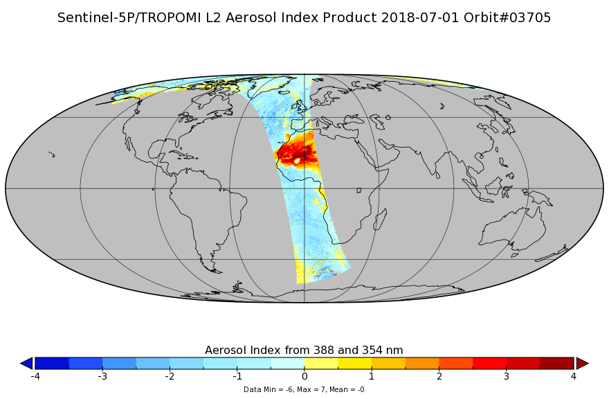
Sentinel-5P TROPOMI Aerosol Index 1-Orbit L2 7km x 3.5km V1 (S5P_L2__AER_AI) at GES DISC
National Aeronautics and Space Administration —
Starting from August 6th in 2019, Sentinel-5P TROPOMI along-track high spatial resolution (~5.5km at nadir) has been implemented. For data after August 6th of 2019,... -
Federal
DSCOVR EPIC Level 2 GLINT
National Aeronautics and Space Administration —
DSCOVR_EPIC_L2_GLINT_01 is Version 1 of the Deep Space Climate Observatory (DSCOVR) Earth Polychromatic Imaging Camera (EPIC) Level 2 glint data product. This product... -
Federal
Sounder SIPS: Suomi NPP CrIMSS Level 2 CLIMCAPS Full Spectral Resolution: Cloud Cleared Radiances V2 at GES DISC
National Aeronautics and Space Administration —
The CLIMCAPS (Community Long-term Infrared Microwave Coupled Product System) algorithm is used to analyze data from the Cross-track Infrared Sounder/Advanced... -
Federal
HRIR/Nimbus-1 Images of Nighttime Brightness Temperature on 70 mm Film V001 (HRIRN1IM) at GES DISC
National Aeronautics and Space Administration —
HRIRN1IM is the Nimbus-1 High-Resolution Infrared Radiometer (HRIR) data product containing scanned negatives of photofacsimile 70mm film strips. The images contain...

Official websites use .gov
A
.gov website belongs to an official government
organization in the United States.
Secure .gov websites use HTTPS
A
lock (
) or https:// means you’ve safely connected to
the .gov website. Share sensitive information only on official,
secure websites.