
-
Federal
SatCORPS CERES GEO Edition 4 Meteosat-8 Northern Hemisphere Version 1.4
National Aeronautics and Space Administration —
CER_GEO_Ed4_MET08_NH_V01.4 is the Satellite Cloud and Radiation Property retrieval System (SatCORPS) Clouds and the Earth's Radiant Energy System (CERES)... -
Federal
UARS Wind Imaging Interferometer (WINDII) Level 3AT V011 (UARWI3AT) at GES DISC
National Aeronautics and Space Administration —
The Wind Imaging Interferometer (WINDII) Level 3AT data product consists of daily, 65.536 second interval time-ordered vertical profiles of meridional and zonal wind... -
Federal
Hardware-in-the-loop Laboratory Performance Verification of Flexible Building Equipment in a Typical Commercial Building: Performance of Heating, Ventilation, and Air Conditioning and Thermal Energy Storage Across the United States
National Institute of Standards and Technology —
This high-fidelity dataset measures the holistic load flexibility performance of a suite of commonly used commercial building heating, ventilating, and air-... -
Federal
GPM SSMIS on F17 (GPROF) Radiometer Precipitation Profiling L3 1 month 0.25 degree x 0.25 degree V07 (GPM_3GPROFF17SSMIS) at GES DISC
National Aeronautics and Space Administration —
Version 07 is the current version of the data set. Older versions will no longer be available and have been superseded by Version 07.3GPROF products provide global... -
Federal
GPM AMSUB on NOAA17 (GPROF) Climate-based Radiometer Precipitation Profiling L3 1 month 0.25 degree x 0.25 degree V07 (GPM_3GPROFNOAA17AMSUB_CLIM) at GES DISC
National Aeronautics and Space Administration —
The "CLIM" products differ from their "regular" counterparts (without the "CLIM" in the name) by the ancillary data they use. They are Climate-Reference products,... -
Federal
MLS/Aura Level 3 Monthly Binned Relative Humidity With Respect To Ice (RHI) on Assorted Grids V004 (ML3MBRHI) at GES DISC
National Aeronautics and Space Administration —
ML3MBRHI is the EOS Aura Microwave Limb Sounder (MLS) monthly binned on various vertical grids product for relative humidity with respect to ice (RHI) derived from... -
Federal
TROPICS01 Pathfinder L1B Orbital Geolocated Native-Resolution Brightness Temperatures V1.0
National Aeronautics and Space Administration —
The "Time-Resolved Observations of Precipitation structure and storm Intensity with a Constellation of Smallsats" (TROPICS) mission has a goal of providing nearly... -
Federal
GPM AMSUB on NOAA15 (GPROF) Climate-based Radiometer Precipitation Profiling L3 1 month 0.25 degree x 0.25 degree V07 (GPM_3GPROFNOAA15AMSUB_CLIM) at GES DISC
National Aeronautics and Space Administration —
The "CLIM" products differ from their "regular" counterparts (without the "CLIM" in the name) by the ancillary data they use. They are Climate-Reference products,... -
Federal
Bowen Ratio Surface Flux: GSFC (FIFE)
National Aeronautics and Space Administration —
The Bowen Ratio Surface Flux Observations (GSFC) Data Set contains data collected using the Bowen Ratio Techniques. The major data collection effort was conducted in... -
Federal
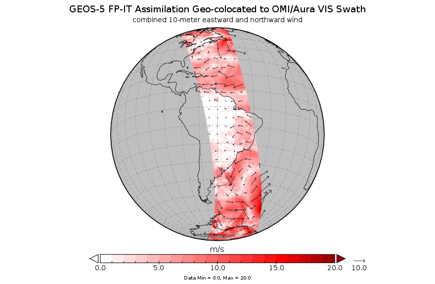
GEOS-5 FP-IT Assimilation Geo-colocated to OMI/Aura VIS 1-Orbit L2 Support Swath 13x24km V3 (OMVFPITMET) at GES DISC
National Aeronautics and Space Administration —
The GEOS-5 FP-IT Assimilation Geo-colocated to OMI/Aura VIS 1-Orbit L2 Support Swath 13x24km (OMVFPITMET) provides selected parameters from GEOS-5 Forward Processing... -
Federal
GPM GMI_R Common Calibrated Brightness Temperatures Collocated L1C 1.5 hours 13 km V07 (GPM_1CGPMGMI_R) at GES DISC
National Aeronautics and Space Administration —
Version 07 is the current version of the data set. Older versions will no longer be available and have been superseded by Version 07.All 1C products have a common L1C... -
Federal
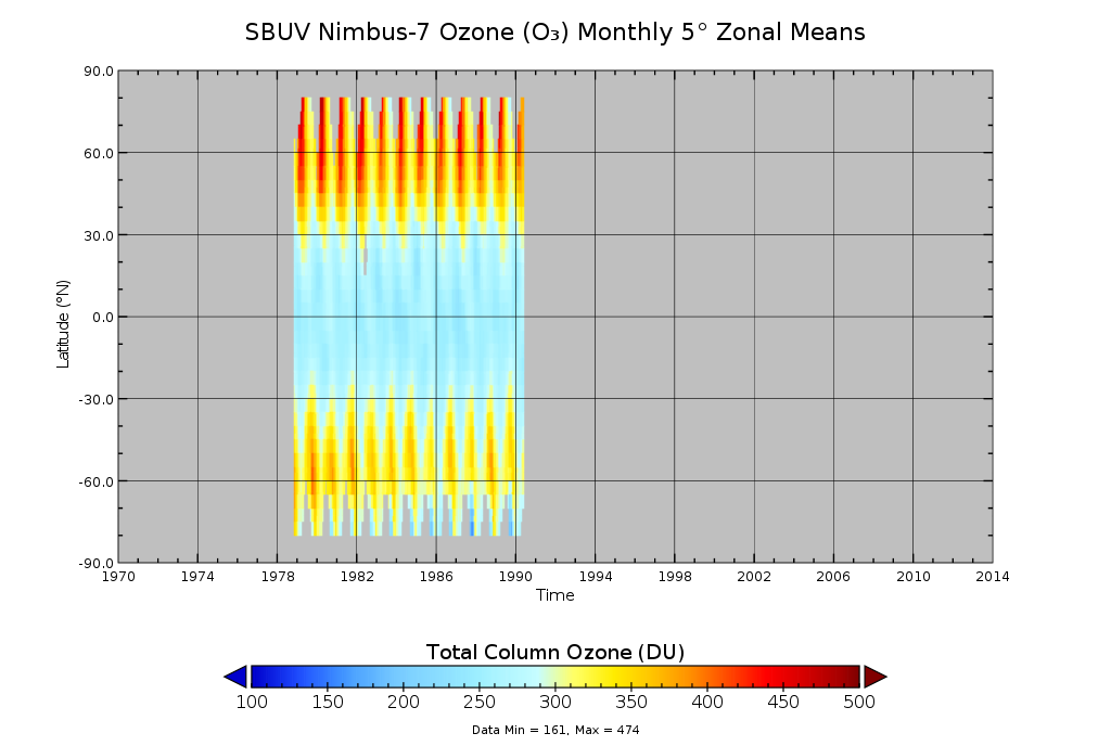
SBUV/Nimbus-7 Ozone (O3) Profile and Total Column Ozone 1 Month Zonal Mean L3 Global 5.0 degree Latitude Zones V1 (SBUVN07L3zm) at GES DISC
National Aeronautics and Space Administration —
The Solar Backscattered Ultraviolet (SBUV) from Nimbus-7 Level-3 monthly zonal mean (MZM) product (SBUVN07L3zm) is derived from the Level-2 retrieved ozone profiles.... -
Federal
Sounder SIPS: Suomi NPP CrIMSS Level 2 CHART Normal Spectral Resolution: Atmosphere, cloud and surface geophysical state V1
National Aeronautics and Space Administration —
The objective of this limited edition data collection is to examine products generated by the Climate Heritage AIRS Retrieval Technique (CHART) algorithm to analyze... -
Federal
LBA-ECO LC-02 GOES-08 Hot Pixel Data from Acre, Brazil: 1998, 2000, and 2001
National Aeronautics and Space Administration —
This data set provides hot pixel data, as an indicator of fires that were detected by the GOES-8 satellite for the state of Acre, Brazil. Image data were collected... -
Federal
GEOS-5 FP-IT 3D Time-Averaged Model-Layer Assimilated Data Geo-Colocated to OMI/Aura VIS 1-Orbit L2 Swath 13x24km V4 (OMVFPMET) at GES DISC
National Aeronautics and Space Administration —
The GEOS-5 FP-IT 3D Time-Averaged Model-Layer Assimilated Data Geo-Colocated to OMI/Aura VIS 1-Orbit L2 Swath 13x24km (OMVFPMET) product provides selected... -
Federal
SAFARI 2000 Global Historical Climatology Network, V. 1, 1874-1990
National Aeronautics and Space Administration —
This data set consists of a southern African subset of the Global Historical Climatology Network (GHCN) Version 1 database. All stations with the following bounding... -
Federal
GPM SSMI on F10 (GPROF) Climate-based Radiometer Precipitation Profiling L3 1 day 0.25 degree x 0.25 degree V07 (GPM_3GPROFF10SSMI_DAY_CLIM) at GES DISC
National Aeronautics and Space Administration —
Version 7 is the current version of the data set. Older versions will no longer be available and have been superseded by the current version. The "CLIM" products... -
Federal
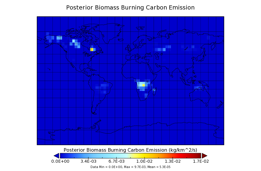
Carbon Monitoring System Flux for Posterior Fire Carbon L4 V1 (CMSFluxFirepost) at GES DISC
National Aeronautics and Space Administration —
This dataset provides the Carbon Flux for Fires.The NASA Carbon Monitoring System (CMS) is designed to make significant contributions in characterizing, quantifying,... -
Federal
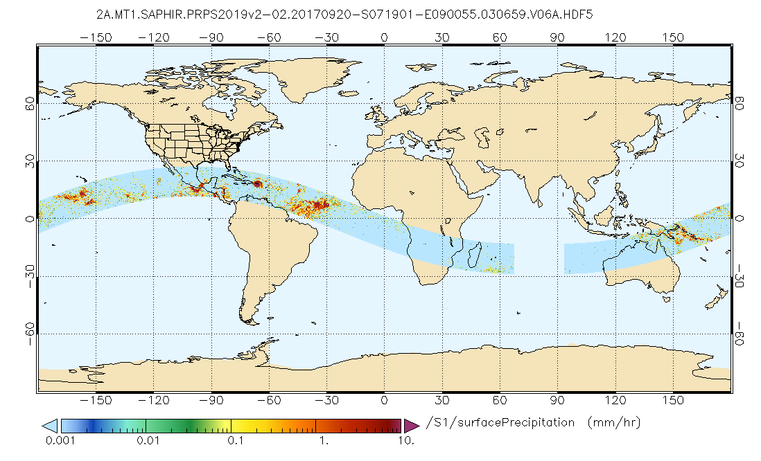
GPM SAPHIR on MT1 (PRPS) Radiometer Precipitation Profiling L2 1.5 hours 10 km V06 (GPM_2APRPSMT1SAPHIR) at GES DISC
National Aeronautics and Space Administration —
Version 6 is the current version of this dataset. Older versions are no longer available and have been superseded by Version 6.The Precipitation Retrieval and... -
Federal
BOREAS TE-02 Root Respiration Data
National Aeronautics and Space Administration —
The BOREAS TE-02 team collected several data sets in support of its efforts to characterize and interpret information on the respiration of the foliage, roots, and...

Official websites use .gov
A
.gov website belongs to an official government
organization in the United States.
Secure .gov websites use HTTPS
A
lock (
) or https:// means you’ve safely connected to
the .gov website. Share sensitive information only on official,
secure websites.