

146 datasets found for "deaf"
-
Federal
Enhanced Terrain Imagery of the Pittsburgh East 30 x 60 Minute Quadrangle from Lidar-Derived Elevation Models at 3-Meter Resolution
Department of the Interior —
This imagery dataset consists of 3-meter resolution, lidar-derived imagery of the Pittsburgh East 30 x 60 minute quadrangle in Pennsylvania. The source data used to... -
Federal
TIGER/Line Shapefile, Current, County, Deaf Smith County, TX, All Roads
U.S. Census Bureau, Department of Commerce —
This resource is a member of a series. The TIGER/Line shapefiles and related database files (.dbf) are an extract of selected geographic and cartographic information... -
Federal
Airborne geophysical survey: West Fork Sampoil River, Washington
Department of the Interior —
Aeromagnetic data were collected along flight lines by instruments in an aircraft that recorded magnetic-field values and locations. This dataset presents latitude,... -
Federal
Structure-from-Motion Products - Prime Hook National Wildlife Refuge, Delaware - Orthomosaic: 2019
Department of the Interior —
Aerial imagery was collected by a contractor using a fixed wing aircraft fitted with Post-Processing Kinematic (PPK) GPS, was processed using Structure-from-Motion... -
City
3.19 Value of Special Events (dashboard)
City of Tempe —
This operations dashboard shows historic and current data related to this performance measure.The performance measure dashboard is available at 3.19 Value of Special... -
Federal
NOAA/WDS Paleoclimatology - Zgraggen - Krauchtaltrocken - FASY - ITRDB SWIT265
National Oceanic and Atmospheric Administration, Department of Commerce —
This archived Paleoclimatology Study is available from the NOAA National Centers for Environmental Information (NCEI), under the World Data Service (WDS) for... -
Federal
NOAA/WDS Paleoclimatology - Ballard fire data from Lake Sixteen - IMPD USL16001
National Oceanic and Atmospheric Administration, Department of Commerce —
This archived Paleoclimatology Study is available from the NOAA National Centers for Environmental Information (NCEI), under the World Data Service (WDS) for... -
Federal
Tracklines for bottom video collected with the SEABOSS Sampler in the Cape Ann - Salisbury Beach survey area (SeaBossTracklines - shapefile, Geographic, WGS84)
Department of the Interior —
These data were collected under a cooperative agreement with the Massachusetts Office of Coastal Zone Management (CZM) and the U.S. Geological Survey, Coastal and... -
Federal
Digital Orthorectified Aerial Image of Cottonwood Lake Study Area Wetland T7 from 2001
Department of the Interior —
Orthorectified image from aerial photograph of wetland T7 in the Cottonwood Lake Study Area, Stutsman County, North Dakota. This image is part of a collection of... -
City
Performance Measure Definition: Trauma Alert Scene Time
City of Austin —
Performance Measure Definition: Trauma Alert Scene Time -
Federal
Evaluation of GPS Monitoring Technologies and Domestic Violence in the United States, 2001-2009
Department of Justice —
This study examines the implementation and effectiveness of Global Positioning System (GPS) monitoring technology to enforce court mandated "no contact" orders in... -
Federal
Salivary biomarkers of immune and neuroendocrine functions, demographic and behavioral data
U.S. Environmental Protection Agency —
This SAS dataset contains data on salivary concentrations of selected immune and neuroendocrine biomarkers, as well as socioeconomic and demographic data, self-... -
Federal
BARREL 4A Data Processing Unit (HKPG) Analog Housekeeping Voltage, Temperature, Current, and Payload Status, Level 2, 40 s Data
National Aeronautics and Space Administration —
Housekeeping voltage, temperature, current, and payload status values returned every 40 s. NOTE: The analog sensor data in these records are based on the nominal... -
Federal
DISCOVER-AQ Maryland Deployment Essex Ground Site Data
National Aeronautics and Space Administration —
DISCOVERAQ_Maryland_Ground_Essex_Data contains data collected at the Essex ground site during the Maryland (Baltimore-Washington) deployment of NASA's DISCOVER-AQ... -
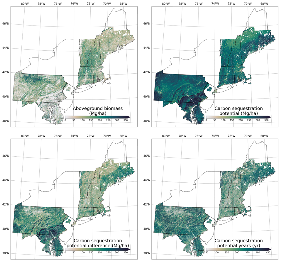
Federal
Forest Aboveground Biomass and Carbon Sequestration Potential, Northeastern USA
National Aeronautics and Space Administration —
This dataset provides 90 m estimates of forest aboveground biomass (Mg/ha) for nominal 2011 and projections of carbon sequestration potential for 11 states in the... -
Federal
ISLSCP II Climate Research Unit CRU05 Monthly Climate Data
National Aeronautics and Space Administration —
This data set contains a mean monthly climatology for several climate variables averaged over the period from 1961 to 1990, and constructed from a data set of station... -
Federal
TIGER/Line Shapefile, 2022, County, Deaf Smith County, TX, Address Range-Feature
U.S. Census Bureau, Department of Commerce —
The TIGER/Line shapefiles and related database files (.dbf) are an extract of selected geographic and cartographic information from the U.S. Census Bureau's Master... -
Federal
Steptoe Valley NV Data Compilation: Understanding a Stratigraphic Hydrothermal Resource through Geophysical Imaging
Department of Energy —
Sandia National Laboratories partnered with a multi-disciplinary group of subject matter experts to evaluate a stratigraphic geothermal resource in Steptoe Valley,... -
State
ODHH
State of Maryland —
Governor’s Office of the Deaf and Hard of Hearing (description updated 2/17/2023) -
Federal
TIGER/Line Shapefile, 2023, County, Deaf Smith County, TX, Address Range-Feature
U.S. Census Bureau, Department of Commerce —
The TIGER/Line shapefiles and related database files (.dbf) are an extract of selected geographic and cartographic information from the U.S. Census Bureau's Master...
146 datasets found for "deaf"