

177 datasets found for "Crops"
-
Federal
Long-term tillage and cropping system experiment for Greenhouse gas Reduction through Agricultural Carbon Enhancement network and Nutrient Use and Outcome Network in Lincoln, Nebraska
Department of Agriculture —
Long-term tillage and cropping system experiment for Greenhouse gas Reduction through Agricultural Carbon Enhancement network and Nutrient Use and Outcome Network in... -
State
i04 CIMIS Weather Stations
State of California —
The California Irrigation Management Information System (CIMIS) currently manages over 145 active weather stations throughout the state. Archived data is also... -
Federal
Puerto Rico Relative Vulnerability to Erosion
National Oceanic and Atmospheric Administration, Department of Commerce —
Physical factors, such as the slope of the land, the texture of the soil, and the precipitation regime influence erosion in an area. Parts of Puerto Rico are very... -
Federal
Global Hyperspectral Imaging Spectral-library of Agricultural crops for Conterminous United States V001
National Aeronautics and Space Administration —
The Global Hyperspectral Imaging Spectral-library of Agricultural crops (GHISA) is a comprehensive compilation, collation, harmonization, and standardization of... -
Federal
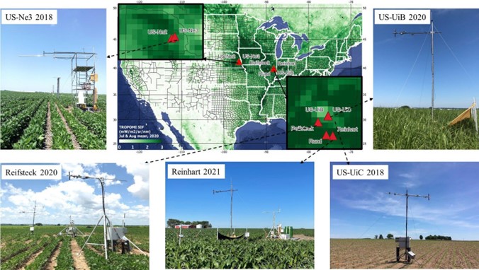
SIF and Vegetation Indices in the US Midwestern Agroecosystems, 2016-2021
National Aeronautics and Space Administration —
This dataset contains half-hourly ground solar-induced chlorophyll fluorescence (SIF) and vegetation indices including NDVI, EVI, Red edge chlorophyll index, green... -
Federal
Data from: Crop Sequence Complexity of the Major Land Resource Areas (MLRA) in the Contiguous United States (CONUS)
Department of Agriculture —
Quantifying spatial and temporal dynamics of crop sequences is often accomplished through crop biodiversity metrics. Existing metrics are confounded by crop sequence... -
Federal
Data from: Thinking Like a Grassland: Challenges and Opportunities for Biodiversity Conservation in the Great Plains of North America
Department of Agriculture —
Conservation planning in the Great Plains often depends on understanding the degree of fragmentation of the various types of grasslands and savannas that historically... -
Federal
Evaluation of SWAT reservoir, ponds, and wetlands tools in water and sediment simulation in the Rock River watershed
U.S. Environmental Protection Agency —
The dataset supported findings in the study: "Evaluation of SWAT reservoir, ponds, and wetlands tools in water and sediment simulation in the Rock River watershed".... -
Federal
EnviroAtlas - Fruit and vegetable crops by 12-digit HUC for the Conterminous United States
U.S. Environmental Protection Agency —
This EnviroAtlas dataset includes data on the area, yield, and number of fruit and vegetable crops grown per 12-digit Hydrologic Unit (HUC) in the conterminous USA.... -
State
Statewide Agricultural Water Use Data 2016-2020
State of California —
Descriptions Excel Application Tool for Statewide Agricultural Water Use Data 2016 - 2020 Department of water resources, Water Use Efficiency Branch, Water Use Unit... -
State
Region Land Use Surveys
State of California —
This is collection of DWR Region Land Use Surveys. These include several county land use surveys, In addition, you may scroll the list below to download any... -
Federal
EnviroAtlas - Agricultural Water Demand by 12-Digit HUC for the Conterminous United States
U.S. Environmental Protection Agency —
The national agricultural water demand metric provides insight into the amount of water used for agricultural irrigation in the contiguous United States. The... -
Federal
Data from: A site suitability analysis for castor (Ricinus communis L.) production during Brazil's second harvest accounting for potential disease
Department of Agriculture —
Raster data providing site suitability results for the production of castor throughout Brazil. The pixel value range from 1 (currently not suitable) to 10 (highly... -
Federal
Agricultural land use by field: Wisconsin 2010-2019
Department of Agriculture —
Improving the quality of water discharged from agricultural watersheds requires comprehensive and adaptive approaches for planning and implementing conservation... -
Federal
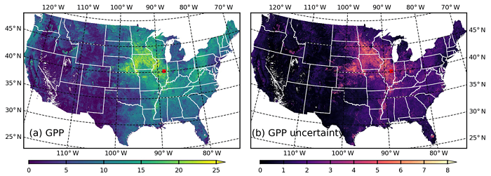
MODIS-based GPP, PAR, fC4, and SANIRv estimates from SLOPE for CONUS, 2000-2019
National Aeronautics and Space Administration —
This dataset contains estimated gross primary productivity (GPP), photosynthetically active radiation (PAR), soil adjusted near infrared reflectance of vegetation... -
Federal
Global Leaf Area Index from Field Measurements, 1932-2000
National Aeronautics and Space Administration —
Approximately 1000 published estimates of leaf area index (LAI) from nearly 400 unique field sites, covering the period 1932-2000, have been compiled into a single... -
Federal
FLUXNET Marconi Conference Gap-Filled Flux and Meteorology Data, 1992-2000
National Aeronautics and Space Administration —
Fluxes of carbon dioxide, water vapor, and energy exchange have been measured at 38 forest, grassland, and crop sites as part of the EUROFLUX and AmeriFlux projects.... -
Federal
Remote Sensing Derived Topsoil and Agricultural Economic Losses, Midwestern USA
National Aeronautics and Space Administration —
This dataset provides estimates of topsoil loss and economic loss associated with decreased crop productivity resulting from topsoil loss at county- and state-levels... -
Federal
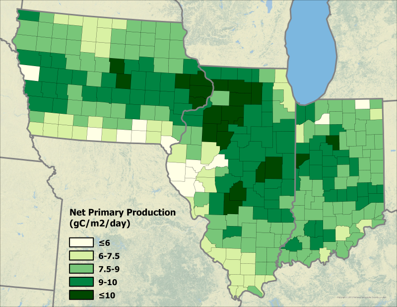
Ecosys Model-Estimated Cropland Carbon Fluxes, Illinois, Indiana, and Iowa, 2001-2018
National Aeronautics and Space Administration —
This dataset contains daily estimates of carbon fluxes in croplands derived from the "ecosys" model covering a portion of the Midwestern US (Illinois, Indiana, and...
177 datasets found for "Crops"