
-
Federal
Land FASAB
Department of Agriculture —
In 2021, the Federal Accounting Standards Advisory Board (FASAB) initiated a tracking mechanism that requires all federal agencies that own or manage land to... -
Federal
Purchase Units under the Weeks Law (Feature Layer)
Department of Agriculture —
A unit designated by the Secretary of Agriculture or previously approved by the National Forest Reservation Commission for purposes of Weeks Law acquisition. Metadata -
Federal
Geopolitical Units adjusted within Administrative Forest Boundaries: Congressional Districts FS revised 2020 Census (Feature Layer)
Department of Agriculture —
The USDA Forest Service Rapid Assessment of Vegetation Condition after Wildfire (RAVG) program produces geospatial and related data representing post-fire vegetation... -
University
Soil Survey Geographic (SSURGO) database for Cibola National Forest Area, New Mexico, Parts of Catron, Cibola, McKinley, Sandoval, Sierra and Socorro Counties
Earth Data Analysis Center, University of New Mexico —
This data set is a digital soil survey and generally is the most detailed level of soil geographic data developed by the National Cooperative Soil Survey. The... -
Federal
EnviroAtlas - Public outdoor recreation areas availability and accessibility for the Conterminous United States
U.S. Environmental Protection Agency —
This EnviroAtlas map estimates the accessibility and availability of public outdoor recreational areas (e.g., urban parks, national forests) within 800m along... -
Federal
LBA-ECO CD-03 Nocturnal Meteorological Data, Forest and Pasture Sites, Para, Brazil
National Aeronautics and Space Administration —
This data set contains measurements of nocturnal meteorological profiles collected from tethered balloon platforms during July 2001, October 2001, and November 2003.... -
Federal
LBA-ECO CD-03 Cloud Base-Backscatter Data, km 67 Tower Site, Tapajos National Forest
National Aeronautics and Space Administration —
A Vaisala CT-25K ceilometer was installed at an old-growth forest site located at the km 67 Eddy Flux Tower site in the Tapajos National Forest, Para, Brazil, off... -
Federal
LBA-ECO LC-03 Hypsography, Rivers, Roads, and DEM, Four Areas across Brazilian Amazon
National Aeronautics and Space Administration —
This data set provides four related spatial data products for four study areas across the Brazilian Amazon: Manaus, Amazonas; Tapajos National Forest, Para Western... -
Federal
LBA-ECO LC-03 SAR Images, Land Cover, and Biomass, Four Areas across Brazilian Amazon
National Aeronautics and Space Administration —
This data set provides three related land cover products for four study areas across the Brazilian Amazon: Manaus, Amazonas; Tapajos National Forest, Para Western... -
Federal
LBA-ECO CD-04 Leaf Photosynthesis and Respiration, Tapajos National Forest: 2000-2006
National Aeronautics and Space Administration —
This data set reports the results of measurements of (1) leaf-level photosynthesis response curves for the effects of temperature, leaf age, warming, irradiation, and... -
Federal
LBA-ECO CD-04 Leaf Litter Data, km 83 Tower Site, Tapajos National Forest, Brazil
National Aeronautics and Space Administration —
Above-ground litter productivity was measured in a 18 ha plot adjacent to the eddy flux tower at the logged forest tower site, km 83, Tapajos National Forest, Para,... -
Federal
LBA-ECO ND-02 Soil Gas and Water Content, Rainfall Exclusion, Tapajos National Forest
National Aeronautics and Space Administration —
This data set reports soil carbon dioxide (CO2) and nitrous oxide (N2O) concentrations and soil volumetric water content (VWC) from a rainfall exclusion experiment... -
Federal
LBA-ECO CD-08 Carbon Isotopes in Belowground Carbon Pools, Amazonas and Para, Brazil
National Aeronautics and Space Administration —
This data set contains carbon isotope signatures from soil organic matter collected from the following sites: the forests of the ZF-2 INPA reserve approximately 80 km... -
Federal
LBA-ECO LC-14 Specific Leaf Area and Phenology, km 67 Site, Para, Brazil: 2001-2006
National Aeronautics and Space Administration —
This data set provides measurements of specific leaf area and monthly phenological observations for selected tree and vine species at the km 67 Seca Floresta site,... -
Federal
LBA-ECO CD-10 Ground-based Biometry Data at km 67 Tower Site, Tapajos National Forest
National Aeronautics and Space Administration —
This data sets reports biometry measurements of the old-growth upland forest at the Para¡ Western (Santarrem)km 67, Primary Forest Tower Site. This site is in the... -
Federal
NPP Boreal Forest: Superior National Forest, USA, 1983-1984, R1
National Aeronautics and Space Administration —
This data set contains two files (.txt format). One file provides ground-based biophysical measurements and above-ground net primary productivity (ANPP) estimates for... -
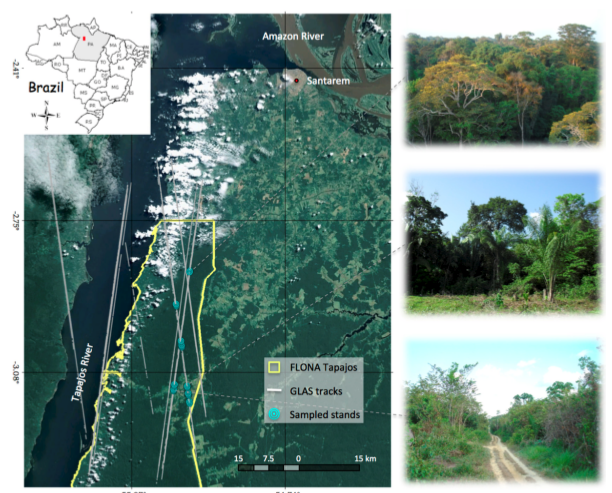
Federal
Tree Inventory and Biometry Measurements, Tapajos National Forest, Para, Brazil, 2010
National Aeronautics and Space Administration —
This dataset provides tree inventory, tree height, diameter at breast height (DBH), and estimated crown measurements from 30 plots located in the Tapajos National... -
State
Aspen Delineation - El Dorado National Forest [ds364]
State of California —
The database represents delineations of known aspen stands, where aspen assessments were gathered in the Eldorado National Forest, Eldorado and Amador Counties,... -
State
Vegetation - State Vehicle Recreation Areas - 2020 [ds3194]
State of California —
The California Department of Parks and Recreation contracted Geographical Information Center (GIC) to conduct vegetation sampling across multiple California State...

Official websites use .gov
A
.gov website belongs to an official government
organization in the United States.
Secure .gov websites use HTTPS
A
lock (
) or https:// means you’ve safely connected to
the .gov website. Share sensitive information only on official,
secure websites.