
-
Federal
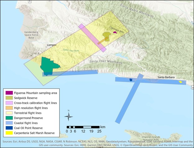
SHIFT: Vegetation Plot Photos, Santa Barbara, CA, USA, 2022
National Aeronautics and Space Administration —
This dataset contains photographs of the plots where field vegetation sampling was conducted during the 2022 NASA Surface Biology Geology (SBG) High Frequency Time... -
Federal
SHIFT: AVIRIS-NG Full-Resolution True Color Images
National Aeronautics and Space Administration —
This dataset holds full-resolution 3-band (true color) imagery acquired by NASA's Airborne Visible / Infrared Imaging Spectrometer-Next Generation (AVIRIS-NG)... -
Federal
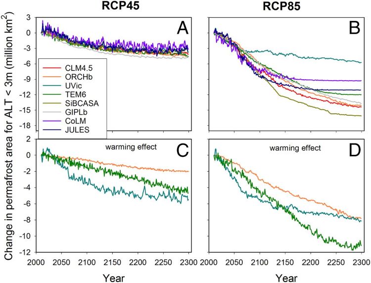
Projections of Permafrost Thaw and Carbon Release for RCP 4.5 and 8.5, 1901-2299
National Aeronautics and Space Administration —
This dataset consists of an ensemble of model projections from 1901 to 2299 for the northern hemisphere permafrost domain. The model projections include monthly... -
Federal
Remote Sensing Data Before and After California Rim and King Forest Fires, 2010-2015
National Aeronautics and Space Administration —
This data set provides high-resolution surface reflectance, thermal imagery, burn severity metrics, and LiDAR-derived structural measures of forested areas in the... -
Federal
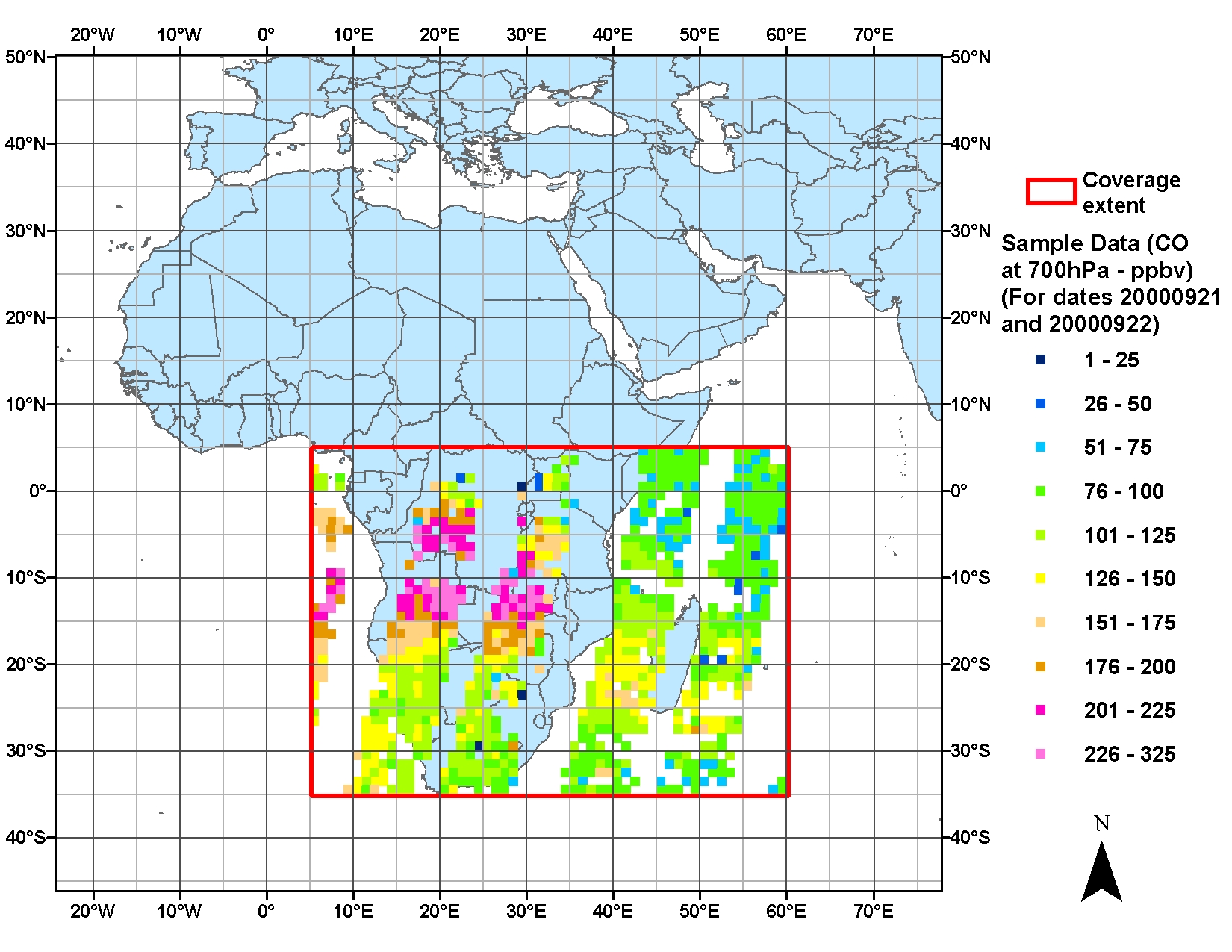
SAFARI 2000 Estimated BVOC Emissions for Southern African Land Cover Types
National Aeronautics and Space Administration —
Improved vegetation distribution and emission data for Africa south of the equator were developed for the Southern African Regional Science Initiative (SAFARI 2000)... -
Federal
NACP: Urban Greenhouse Gases across the CO2 Urban Synthesis and Analysis Network, V2
National Aeronautics and Space Administration —
This dataset provides hourly urban greenhouse gas measurements for cities in the CO2 Urban Synthesis and Analysis (CO2-USA) Data Synthesis Network for 2000 to 2019.... -
Federal
ATom: Trace Gas Measurements from PANTHER Gas Chromatograph
National Aeronautics and Space Administration —
This dataset contains measurements of various trace gases from the PAN and Trace Hydrohalocarbon ExpeRiment (PANTHER) across the four ATom campaigns. PANTHER uses... -
Federal
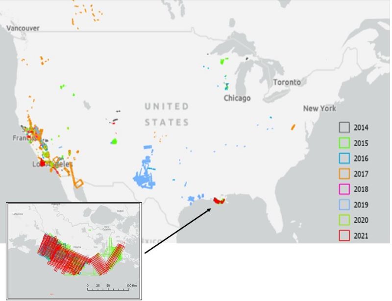
AVIRIS Facility Instruments: Flight Line Geospatial and Contextual Data
National Aeronautics and Space Administration —
This dataset provides attributed geospatial and tabular information for identifying and querying flight lines of interest for the Airborne Visible InfraRed Imaging... -
Federal
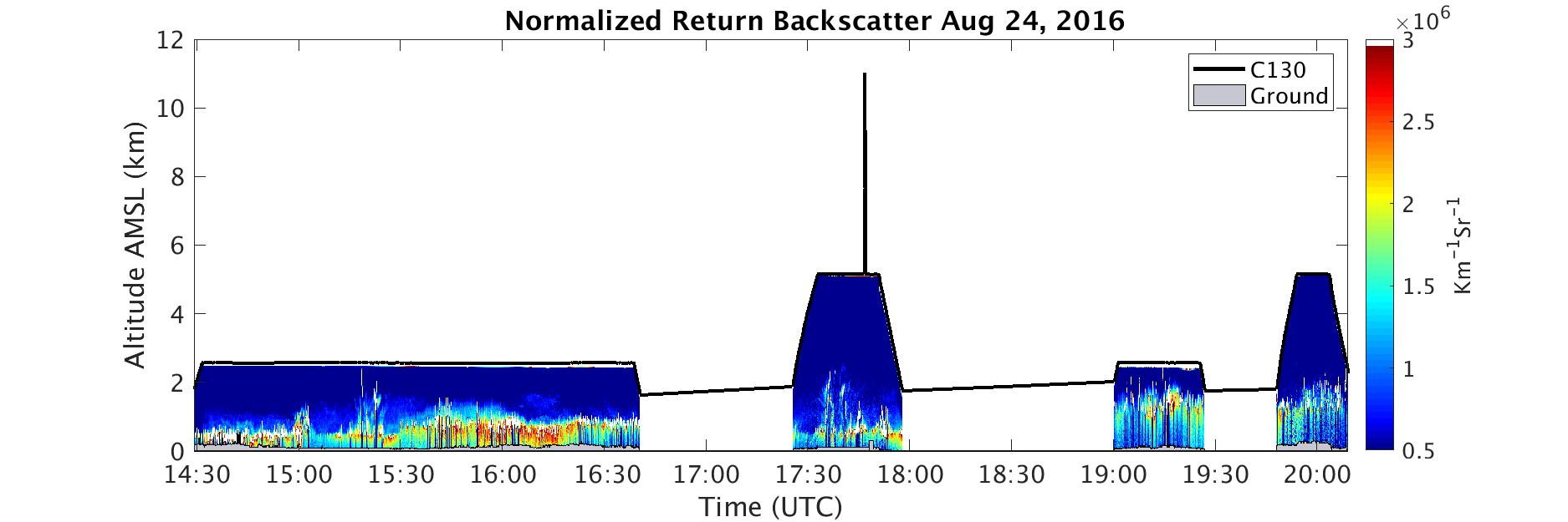
ATom: In-Situ Measurements of Airflow and Aerosols from Multiple Airborne Campaigns
National Aeronautics and Space Administration —
This dataset provides results of selected in-situ measurements of airflow and aerosol particles collected during the following airborne campaigns: NASA Atmospheric... -
Federal
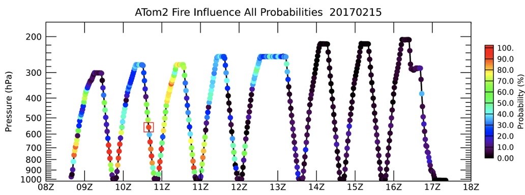
ATom: Back Trajectories and Influences of Air Parcels Along Flight Track, 2016-2018
National Aeronautics and Space Administration —
This dataset contains back trajectories, boundary layer influences, and convective influences of air parcels along NASA DC-8 aircraft's flight tracks during the four... -
Federal
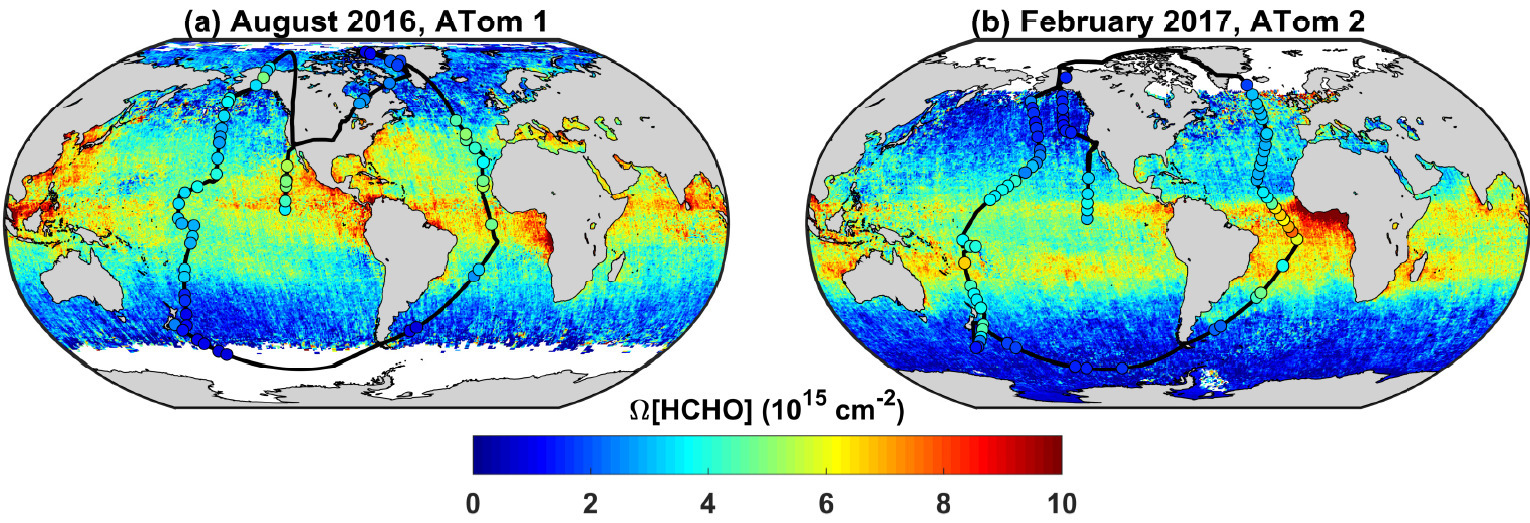
ATom: Column-Integrated Densities of Hydroxyl and Formaldehyde in Remote Troposphere
National Aeronautics and Space Administration —
This dataset provides profile-integrated column densities of formaldehyde (HCHO), hydroxyl (OH), and OH production rates, diel tropospheric mean OH concentrations,... -
Federal
ATom: CO2, CH4, and CO Measurements from Picarro, 2016-2018
National Aeronautics and Space Administration —
This dataset contains atmospheric measurements of CO2, CH4, and CO mixing ratios made with a Picarro G2401 spectrometer during the four ATom campaigns. Picarro G2401... -
Federal
SAFARI 2000 MOPITT Tropospheric Carbon Monoxide, Southern Africa, Dry Season 2000
National Aeronautics and Space Administration —
The MOPITT (Measurements Of Pollution In The Troposphere) instrument on the NASA Terra Satellite makes measurements of infrared radiation originating from the surface... -
Federal
MODIS-derived Aggregate, Woody and Herbaceous Leaf Area Index for Africa, 2002-2022
National Aeronautics and Space Administration —
This dataset provides leaf area index (LAI) estimates for Sub-Saharan Africa for woody, herbaceous, and aggregate vegetation types. The estimates were derived from... -
Federal
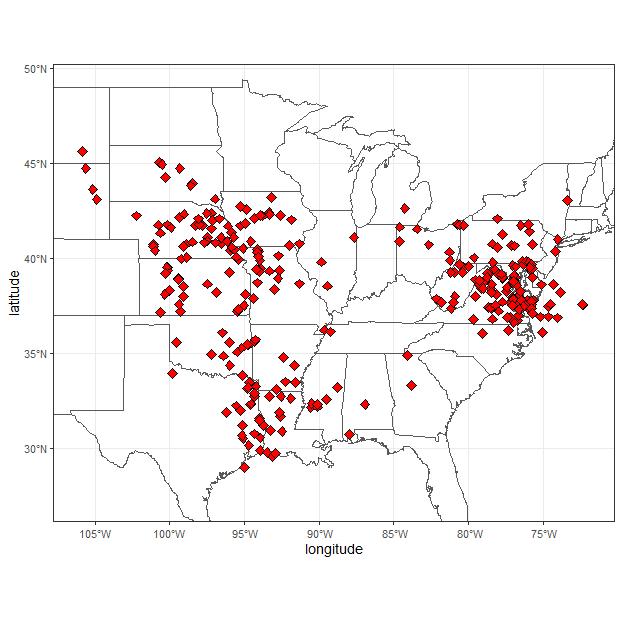
ACT-America: L2 Weighting Functions for Airborne Lidar Column-avg CO2, Eastern USA
National Aeronautics and Space Administration —
This dataset provides vertical weighting function coefficients of the Level 2 (L2) remotely sensed column-average carbon dioxide (CO2) concentrations measured during... -
Federal
ABoVE: Modeled Top Cover by Plant Functional Type over Alaska and Yukon, 1985-2020
National Aeronautics and Space Administration —
This dataset contains data files of modeled top cover estimates by plant functional type (PFT) for the Arctic and Boreal Alaska and Yukon regions. Estimates are... -
Federal
ABoVE: Characterization of Carbon Dynamics in Burned Forest Plots, NWT, Canada, 2014
National Aeronautics and Space Administration —
This dataset provides field data from boreal forests in the Northwest Territories (NWT), Canada, that were burned by wildfires in 2014. During fieldwork in 2015, 211... -
Federal
ABoVE: Wolf Denning Phenology and Reproductive Success, Alaska and Canada, 2000-2017
National Aeronautics and Space Administration —
This dataset provides annual gray wolf (Canis lupus) denning spatial information and timing, associated climatic and phenologic metrics, and reproductive success... -
Federal
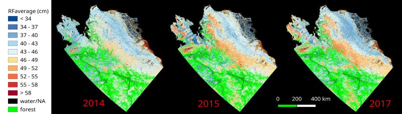
ABoVE: Upscaled Active Layer Thickness in Northern Alaska, 2014-2017
National Aeronautics and Space Administration —
The dataset consists of maps of estimated Active Layer Thickness (ALT) at 30-m resolution throughout the northern half of Alaska for the years 2014, 2015, and 2017....

Official websites use .gov
A
.gov website belongs to an official government
organization in the United States.
Secure .gov websites use HTTPS
A
lock (
) or https:// means you’ve safely connected to
the .gov website. Share sensitive information only on official,
secure websites.