
-
Federal
Site Averaged Gravimetric Soil Moisture: 1987 (Betts)
National Aeronautics and Space Administration —
The Site Averaged Gravimetric Soil Moisture Data: 1987 (Betts) Data Set contains the site averaged product data collected during the 1987-1989 FIFE experiment.... -
Federal
NPP Tropical Forest: Luquillo, Puerto Rico, 1946-1994, R1
National Aeronautics and Space Administration —
This data set contains ten ASCII files (.txt format), one NPP file for each of the nine different montane tropical rainforest sites within the Luquillo Experimental... -
Federal
NPP Tropical Forest: Cinnamon Bay, U.S. Virgin Islands, 1982-1993, R1
National Aeronautics and Space Administration —
This data set contains three ASCII files (.txt format). One data file contains above-ground biomass, litter, litterfall, herbivory, biomass change, and above-ground... -
Federal
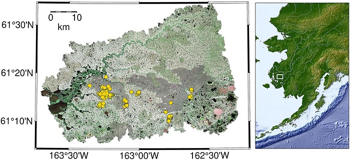
Aboveground Biomass Density for High Latitude Forests from ICESat-2, 2020
National Aeronautics and Space Administration —
This dataset provides estimates of Aboveground dry woody Biomass Density (AGBD) for high northern latitude forests at a 30-m spatial resolution. It is designed both... -
Federal
Forest Inventories at Burned and Unburned Tropical Forest Sites, Acre, Brazil, 2014
National Aeronautics and Space Administration —
This dataset provides measurements for diameter at breast height (DBH) and species identification of trees for inventories taken at five tropical forest sites in Acre... -
Federal
Forest Aboveground Biomass and Carbon Sequestration Potential for Maryland, USA.
National Aeronautics and Space Administration —
This dataset provides 90-m resolution maps of estimated forest aboveground biomass (Mg/ha) for nominal year 2011 and projections of carbon sequestration potential for... -
Federal
Global Soil Types, 0.5-Degree Grid (Modified Zobler)
National Aeronautics and Space Administration —
A global data set of soil types is available at 0.5-degree latitude by 0.5-degree longitude resolution. There are 106 soil units, based on Zobler?s (1986) assessment... -
Federal
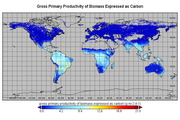
Global Monthly GPP from an Improved Light Use Efficiency Model, 1982-2016
National Aeronautics and Space Administration —
This dataset provides global monthly average gross primary productivity (GPP; g carbon/m2/d) modeled at 8 km spatial resolution for each of the 35 years from... -
Federal
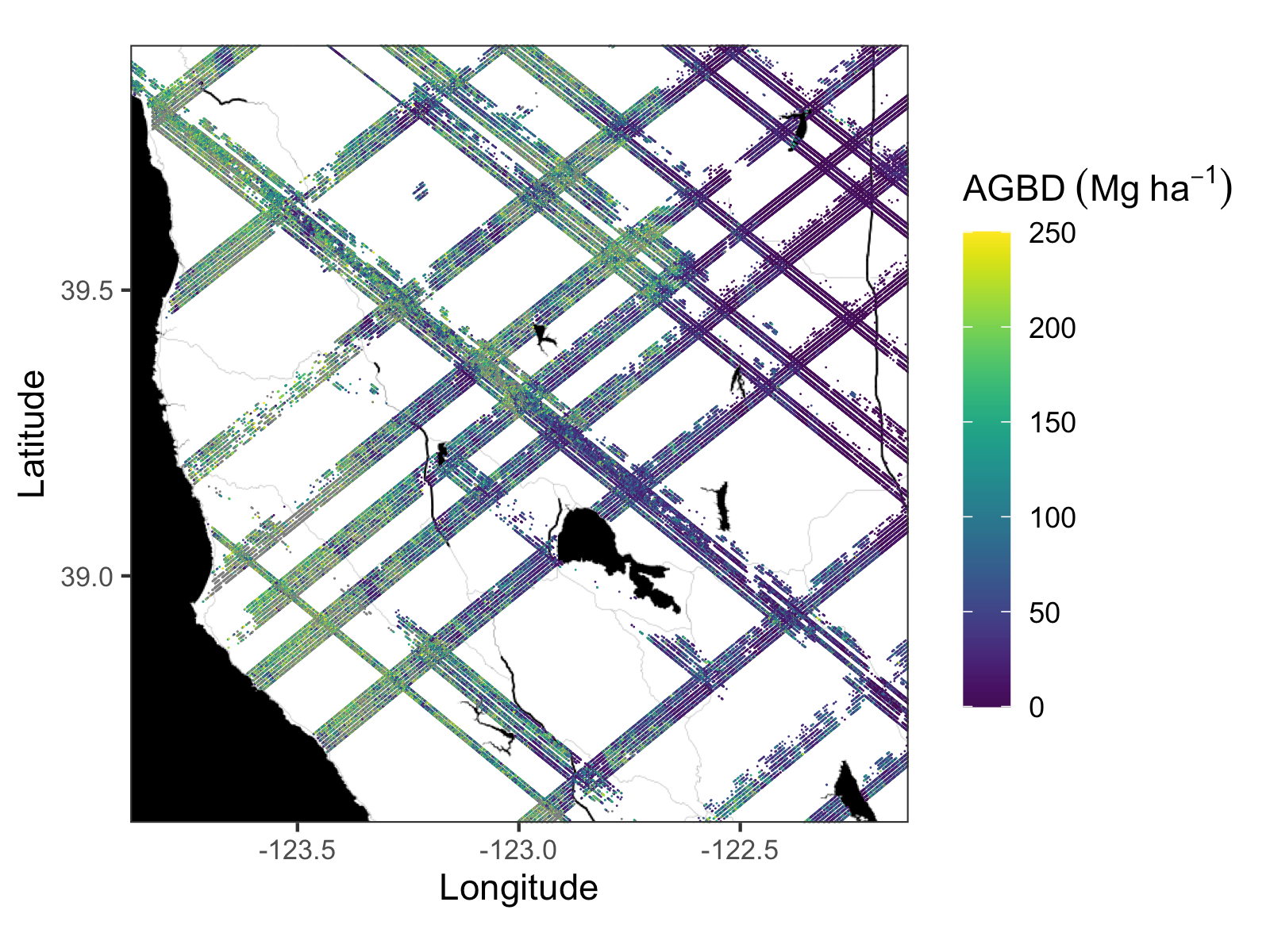
Gridded GEDI Vegetation Structure Metrics and Biomass Density at Multiple Resolutions
National Aeronautics and Space Administration —
This dataset consists of near-global, analysis-ready, multi-resolution gridded vegetation structure metrics derived from NASA Global Ecosystem Dynamics Investigation... -
Federal
GEDI L4A Footprint Level Aboveground Biomass Density, Golden Weeks, Version 1
National Aeronautics and Space Administration —
This dataset contains Global Ecosystem Dynamics Investigation (GEDI) Level 4A (L4A) predictions of the aboveground biomass density (AGBD; in Mg/ha) and estimates of... -
Federal
Delta-X: AVIRIS-NG BRDF-Adjusted Surface Reflectance and Mosaics, MRD, LA, 2021, V3
National Aeronautics and Space Administration —
This data provides AVIRIS-NG Bidirectional Reflectance Distribution Function (BRDF) and sunglint-corrected surface spectral reflectance images over the Atchafalaya... -
Federal
CO2 and CH4 Fluxes from Waterbodies, Yukon-Kuskokwim Delta, Alaska, 2016-2019
National Aeronautics and Space Administration —
This dataset provides estimates of carbon dioxide (CO2) and methane (CH4) diffusive fluxes from waterbodies, and watershed landcover data for the central-interior of... -
Federal
Coastal Wetland Elevation and Carbon Flux Inventory with Uncertainty, USA, 2006-2011
National Aeronautics and Space Administration —
This dataset provides maps of coastal wetland carbon and methane fluxes and coastal wetland surface elevation from 2006 to 2011 at 30 m resolution for coastal... -
Federal
CARVE: L2 Atmospheric Gas Concentrations, Tower-based Flasks, Alaska, 2012-2015
National Aeronautics and Space Administration —
This data set provides atmospheric carbon dioxide, methane, carbon monoxide, molecular hydrogen, nitrous oxide, sulfur hexafluoride, and other trace gas mole... -
Federal
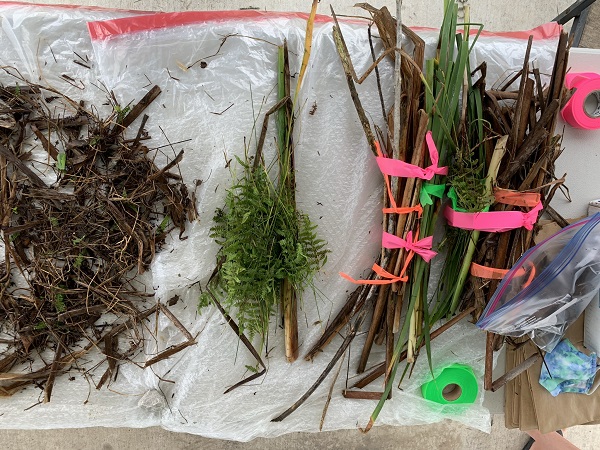
Delta-X: Aboveground Vegetation Structure, Herbaceous Wetlands, MRD, LA, USA, V2
National Aeronautics and Space Administration —
This dataset provides mean stem diameter, mean height, dominant species, hydrogeomorphic zone (HGM), and stem density for vegetation in herbaceous wetlands collected... -
Federal
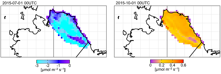
ABoVE: TVPRM Simulated Net Ecosystem Exchange, Alaskan North Slope, 2008-2017
National Aeronautics and Space Administration —
This dataset includes hourly net ecosystem exchange (NEE) simulated by the Tundra Vegetation Photosynthesis and Respiration Model (TVPRM) at 30 km horizontal... -
Federal
ABoVE: Wetland Type, Slave River and Peace-Athabasca Deltas, Canada, 2007 and 2017
National Aeronautics and Space Administration —
This dataset provides ecosystem-types for the Slave River Delta (SRD) and Peace-Athabasca Delta (PAD), Canada, for the time periods circa 2007 and circa 2017. The... -
Federal
ABoVE: Lake and Pond Extents in Alaskan Boreal and Tundra Subregions, 2019-2021
National Aeronautics and Space Administration —
This dataset provides polygon spatial files of lake and pond extents for three sub-regions of Interior Alaska's boreal forest, and one tundra region located in... -
Federal
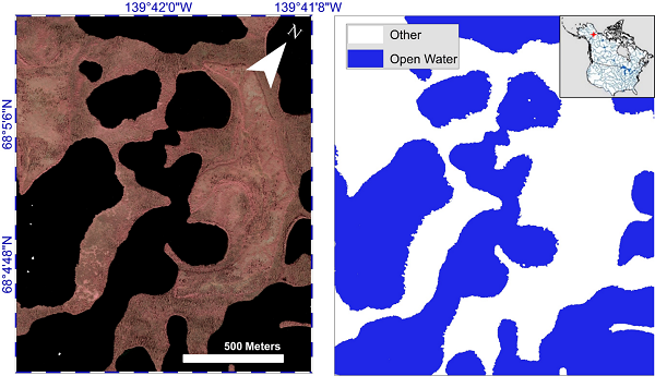
ABoVE: AirSWOT Water Masks from Color-Infrared Imagery over Alaska and Canada, 2017
National Aeronautics and Space Administration —
This dataset provides 1) a conservative open water mask for future water surface elevation (WSE) extraction from the co-registered AirSWOT Ka-band interferometry... -
Federal
BOREAS TGB-08 Monoterpene Concentration Data over the SSA-OBS and the SSA-OJP
National Aeronautics and Space Administration —
The TGB-08 team collected data to investigate the controls over non-methane hydrocarbon (NMHC) fluxes from boreal forest tree species. This data set contains...

Official websites use .gov
A
.gov website belongs to an official government
organization in the United States.
Secure .gov websites use HTTPS
A
lock (
) or https:// means you’ve safely connected to
the .gov website. Share sensitive information only on official,
secure websites.