
-
Federal
ABoVE: AVIRIS-3 Imaging Spectroscopy for Alaska and Canada, 2023
National Aeronautics and Space Administration —
This dataset includes L1B radiance and L2A surface reflectance imagery acquired by the Airborne Visible / Infrared Imaging Spectrometer-3 (AVIRIS-3) instrument over... -
Federal
A Global Database of Soil Phosphorus Compiled from Studies Using Hedley Fractionation
National Aeronautics and Space Administration —
This data set provides concentrations of soil phosphorus (P) compiled from the peer-reviewed literature that cited the Hedley fractionation method (Hedley and... -
Federal
ABoVE: Wolf Denning Phenology and Reproductive Success, Alaska and Canada, 2000-2017
National Aeronautics and Space Administration —
This dataset provides annual gray wolf (Canis lupus) denning spatial information and timing, associated climatic and phenologic metrics, and reproductive success... -
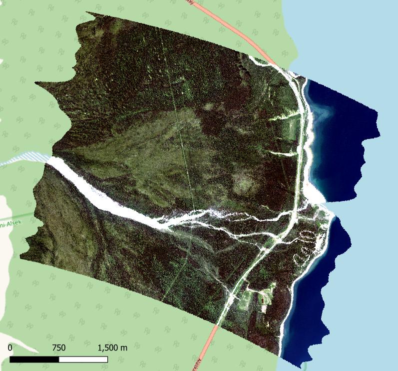
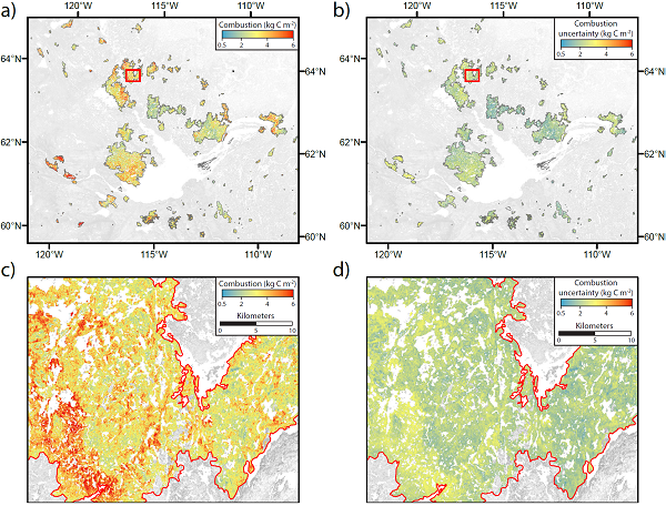
Federal
ABoVE: Wildfire Carbon Emissions and Burned Plot Characteristics, NWT, CA, 2014-2016
National Aeronautics and Space Administration —
This dataset provides estimates of wildfire carbon emissions and uncertainties at 30-m resolution, and measurements collected at burned and unburned field plots from... -
Federal
Canopy Height and Biomass from LiDAR Surveys at La Selva, Costa Rica, 1998 and 2005
National Aeronautics and Space Administration —
This data set contains land-use, canopy height, and aboveground carbon estimates derived from LiDAR data collected at La Selva Biological Station in Costa Rica in... -
Federal
BOREAS RSS-19 1994 Seasonal Understory Reflectance Data
National Aeronautics and Space Administration —
One objective of BOREAS is to further the understanding of the spectral bi-directional reflectance of typical boreal ecosystem stands in the visible/near-infrared... -
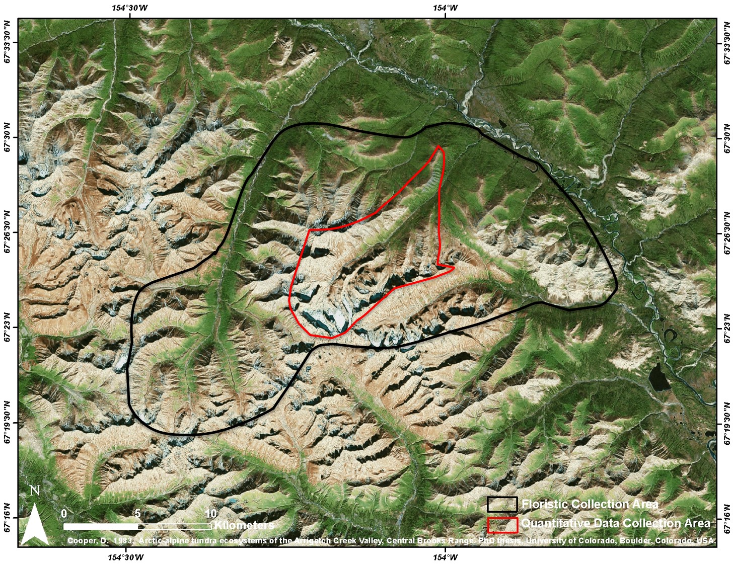
Federal
Arctic Vegetation Plots at Arrigetch Peaks, Alaska, 1978-1981
National Aeronautics and Space Administration —
This data set provides environmental and vegetation data collected between 1978 and 1981 from 439 study plots at Arrigetch Peaks research site, located in the Gates... -
Federal
Delta-X: Soil Properties for Herbaceous Wetlands, MRD, Louisiana, 2021, V3
National Aeronautics and Space Administration —
This dataset contains properties of soil core samples for herbaceous wetlands collected in the Atchafalaya and Terrebonne basins in southeastern coastal Louisiana for... -
Federal
COMEX: AMOG Surface Mobile in situ Data Surveyor, USA, 2014-2015
National Aeronautics and Space Administration —
This dataset provides AutoMObile trace Gas Surveyor (AMOG) in situ relevant datasets collected during the CO2 and Methane EXperiment (COMEX) field campaign and... -
Federal
BOREAS TF-11 SSA Fen Soil Surface CO2 Flux Data
National Aeronautics and Space Administration —
The BOREAS TF-11 team gathered a variety of data to complement their tower flux measurements collected at the SSA Fen site. These data are soil surface CO2 flux data... -
Federal
BOREAS Regional Soils Data in Raster Format and AEAC Projection
National Aeronautics and Space Administration —
This data set was gridded by BORIS staff from a vector data set received from Canadian Soil Information System (CanSIS). The original data came in two parts that... -
Federal
BOREAS TGB-12 Soil Carbon and Flux Data of NSA-MSA in Raster Format
National Aeronautics and Space Administration —
The BOREAS TGB-12 team made measurements of soil carbon inventories, carbon concentration in soil gases, and rates of soil respiration at several sites. This data set... -
Federal
BigFoot Leaf Area Index Surfaces for North and South American Sites, 2000-2003
National Aeronautics and Space Administration —
The BigFoot project gathered leaf area index (LAI) data for nine EOS Land Validation Sites located from Alaska to Brazil from 2000 to 2003. Each site is... -
Federal
BigFoot GPP Surfaces for North and South American Sites, 2000-2004
National Aeronautics and Space Administration —
The BigFoot project gathered Gross Primary Production (GPP) data for nine EOS Land Validation Sites located from Alaska to Brazil from 2000 to 2004. Each site is... -
Federal
BigFoot Field Data for North American Sites, 1999-2003
National Aeronautics and Space Administration —
The BigFoot project gathered field data for selected EOS Land Validation Sites in North America from 1999 to 2003. Data collected and derived for varying intervals at... -
Federal
BigFoot Land Cover Surfaces for North and South American Sites, 2000-2003
National Aeronautics and Space Administration —
The BigFoot project gathered data for nine EOS Land Validation Sites located from Alaska to Brazil from 2000 to 2003. Each site is representative of one or two... -
Federal
Digital Elevation Models for the Global Change Research Wetland, Maryland, USA, 2016
National Aeronautics and Space Administration —
This dataset contains four alternative digital elevation models (DEMs) at 1 m resolution and model performance statistical metrics for the Global Change Research... -
Federal
Soil CO2 Flux Data (FIFE)
National Aeronautics and Space Administration —
In the Soil Carbon Dioxide Flux study, a prototype gas exchange system and sensor were used to determine the soil surface flux of CO2 and associated parameters at the... -
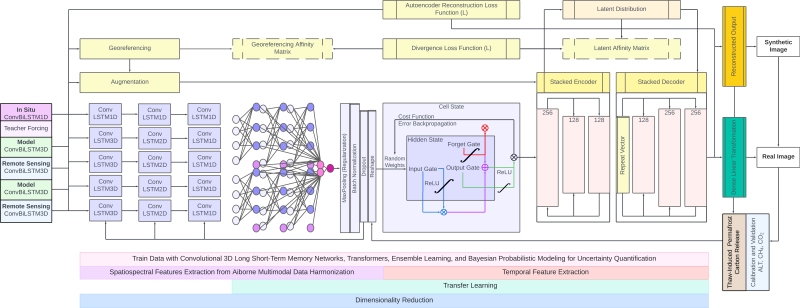
Federal
GeoCryoAI: Ensemble Learning and the Permafrost Carbon Feedback in Alaska, 1963-2022
National Aeronautics and Space Administration —
This dataset provides model code, input data, sample results, and documentation for an artificial intelligence-driven model, GeoCryoAI. GeoCryoAI is a hybridized... -
Federal
Soil Moisture Data: Peck (FIFE)
National Aeronautics and Space Administration —
Water content measurements by gravimetric methods involve weighing a wet sample, removing the water via drying in an oven, and reweighing the sample to determine the...

Official websites use .gov
A
.gov website belongs to an official government
organization in the United States.
Secure .gov websites use HTTPS
A
lock (
) or https:// means you’ve safely connected to
the .gov website. Share sensitive information only on official,
secure websites.