

GeoCryoAI: Ensemble Learning and the Permafrost Carbon Feedback in Alaska, 1963-2022
Access & Use Information
Public: This dataset is intended for public access and use.
License: No license information was provided. If this work was prepared by an officer or employee of the United States government as part of that person's official duties it is considered a U.S. Government Work.
Downloads & Resources
-
Data Information (Unknown Format)BIN
-
Data Information (HTML)HTML
-
Data Information (JPEG)JPEG
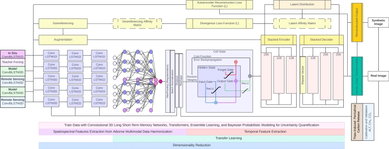
GeoCryoAI_PermafrostThaw_CFlux_Fig1.jpg
-
Data Information (Unknown Format)BIN
-
Data Information (PDF)PDF
GeoCryoAI_PermafrostThaw_CFlux.pdf
-
Landing PageLanding Page
Dates
| Metadata Created Date | April 24, 2025 |
|---|---|
| Metadata Updated Date | August 30, 2025 |
Metadata Source
- Data.json Data.json Metadata
Harvested from NASA Data.json
Additional Metadata
| Resource Type | Dataset |
|---|---|
| Metadata Created Date | April 24, 2025 |
| Metadata Updated Date | August 30, 2025 |
| Publisher | ORNL_DAAC |
| Maintainer | |
| Identifier | 10.3334/ORNLDAAC/2371 |
| Data Last Modified | 2025-08-27 |
| Category | Earth Science |
| Public Access Level | public |
| Bureau Code | 026:00 |
| Metadata Context | https://project-open-data.cio.gov/v1.1/schema/catalog.jsonld |
| Schema Version | https://project-open-data.cio.gov/v1.1/schema |
| Catalog Describedby | https://project-open-data.cio.gov/v1.1/schema/catalog.json |
| Harvest Object Id | 87f9d6c7-1d7c-4f26-9666-d3bdf400d712 |
| Harvest Source Id | 58f92550-7a01-4f00-b1b2-8dc953bd598f |
| Harvest Source Title | NASA Data.json |
| Homepage URL | https://search.earthdata.nasa.gov/search?q=GeoCryoAI_PermafrostThaw_CFlux_2371&ac=true |
| Old Spatial | {"WestBoundingCoordinate":-170.0,"NorthBoundingCoordinate":72.0,"EastBoundingCoordinate":-134.776,"SouthBoundingCoordinate":54.0},"CARTESIAN" |
| Program Code | 026:000 |
| Source Datajson Identifier | True |
| Source Hash | 3abbaf16161949ed318ccb2620215ab18bd22bb1a5e9c7794af82e25db34ccd2 |
| Source Schema Version | 1.1 |
| Spatial | |
| Temporal | 1960-01-01/1960-01-01 |
Didn't find what you're looking for? Suggest a dataset here.