
-
Federal
Feed the Future Ghana: 2015 Interim Population-Based Survey recent views
US Agency for International Development —
Feed the Future (FTF) initiative in Ghana is a collaborative effort that supports country-owned processes and plans for improving food security and nutrition,... -
State
CA HQ Transit Areas recent views
State of California —
Estimated High Quality Transit Areas as described in Public Resources Code 21155, 21064.3, 21060.2. -
Federal
CDC WONDER: Daily Fine Particulate Matter recent views
U.S. Department of Health & Human Services —
The Daily Fine Particulate Matter data available on CDC WONDER are geographically aggregated daily measures of fine particulate matter in the outdoor air, spanning... -
City
Polling Places recent views
City of Chesapeake —
Polling places in the City of Chesapeake. Maintained by Voter Registrar. -
Federal
Rural Health Clinic All Owners recent views
U.S. Department of Health & Human Services —
The Rural Health Clinic (RHC) All Owners dataset provides ownership information on all RHCs currently enrolled in Medicare. This data includes ownership information... -
Federal
2014 Horry County, South Carolina Lidar recent views
National Oceanic and Atmospheric Administration, Department of Commerce —
This data set is comprised of lidar point cloud data. This project required lidar data to be acquired over Horry County, South Carolina. The total area of the Horry... -
Federal
MODIS/Terra+Aqua Land Cover Type Yearly L3 Global 0.05Deg CMG V061 NGDA recent views
National Aeronautics and Space Administration —
The Terra and Aqua combined Moderate Resolution Imaging Spectroradiometer (MODIS) Land Cover Climate Modeling Grid (CMG) (MCD12C1) Version 6.1 data product provides a... -
State
Groundwater Management Area Lower Umatilla recent views
State of Oregon —
This polygon layer contains a spatial representation of a geographic area that is designated as a Groundwater Management Area for the Lower Umatilla Basin in Oregon. -
Federal
TES/Aura L2 Ozone Nadir V007 recent views
National Aeronautics and Space Administration —
TL2O3N_7 is the Tropospheric Emission Spectrometer (TES)/Aura Level 2 Ozone Nadir Version 7 data product. It consists of information for one molecular species for an... -
Federal
TreeMap 2016 Live Tree Basal Area (Image Service) recent views
Department of Agriculture —
TreeMap 2016 provides a tree-level model of the forests of the conterminous United States.Metadata and DownloadsWe matched forest plot data from Forest Inventory and... -
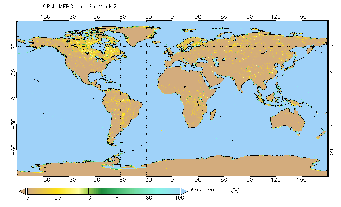
Federal
Land/Sea static mask relevant to IMERG precipitation 0.1x0.1 degree V2 (GPM_IMERG_LandSeaMask) at GES DISC recent views
National Aeronautics and Space Administration —
Version 2 is the current version of the data set. Older versions will no longer be available and have been superseded by Version 2. This land sea mask originated from... -
Federal
MISR Level 3 Component Global Radiance Regional public Product covering a day V002 recent views
National Aeronautics and Space Administration —
MI3DRDR_2 is the Multi-angle Imaging SpectroRadiometer (MISR) Level 3 Component Global Radiance Regional public Product covering a day version 2. It contains a global... -
Federal
Collection TIGER/Line Shapefile, 2019, Series Information for the opological Faces (Polygons With All Geocodes) County-based Shapefile recent views
U.S. Census Bureau, Department of Commerce —
The TIGER/Line shapefiles and related database files (.dbf) are an extract of selected geographic and cartographic information from the U.S. Census Bureau's Master... -
Federal
ERS Data APIs recent views
Department of Agriculture —
The ERS content and data APIs (including our pre-made widgets for embedding charts) are currently out of service while we redesign our site. Check back here for... -
University
New Mexico State Parks recent views
Earth Data Analysis Center, University of New Mexico —
This dataset provides an initial version of the generalized physical boundaries of New Mexico State Parks, in polygonal form with limited attributes, compiled using... -
Federal
End-Stage Renal Disease Facility Aggregation Group Performance recent views
U.S. Department of Health & Human Services —
The End-Stage Renal Disease (ESRD) Facility Aggregation Group Performance dataset provides performance information in the End-Stage Renal Disease (ESRD) Treatment... -
Federal
Regional Hydrodynamic Model Outputs of the NOAA Gulf of Maine Operational Forecast System (GoMOFS) recent views
National Oceanic and Atmospheric Administration, Department of Commerce —
NOAA's National Ocean Service (NOS) has developed a Gulf of Maine Operational Forecast System (GoMOFS). Based on Rutgers University's Regional Ocean Modeling System... -
2019 Traffic Volume recent views
District of Columbia —
Traffic volume of Roadway Blocks. The dataset contains traffic volume data, created as part of the District of Columbia, Department of Transportation (DDOT) Roads and... -
Federal
Aqua/AIRS L3 Daily Standard Physical Retrieval (AIRS-only) 1 degree x 1 degree V7.0 at GES DISC recent views
National Aeronautics and Space Administration —
The Atmospheric Infrared Sounder (AIRS) is a grating spectrometer (R = 1200) aboard the second Earth Observing System (EOS) polar-orbiting platform, EOS Aqua. The... -
University
Bernalillo County 2010 Census Edges recent views
Earth Data Analysis Center, University of New Mexico —
The TIGER/Line Files are shapefiles and related database files (.dbf) that are an extract of selected geographic and cartographic information from the U.S. Census...

Official websites use .gov
A
.gov website belongs to an official government
organization in the United States.
Secure .gov websites use HTTPS
A
lock (
) or https:// means you’ve safely connected to
the .gov website. Share sensitive information only on official,
secure websites.