
-
Federal
Imagery data for the Vegetation Mapping Inventory Project of Marsh-Billings-Rockefeller National Historical Park
Department of the Interior —
This reference contains the imagery data used in the completion of the baseline vegetation inventory project for the NPS park unit. Orthophotos, raw imagery, and... -
Federal
NOAA/WDS Paleoclimatology - Brown fire data from Lone Pine Upper - IMPD USLPU001
National Oceanic and Atmospheric Administration, Department of Commerce —
This archived Paleoclimatology Study is available from the NOAA National Centers for Environmental Information (NCEI), under the World Data Service (WDS) for... -
Federal
Imagery data for the Vegetation Mapping Inventory Project of Joshua Tree National Park
Department of the Interior —
This reference contains the imagery data used in the completion of the baseline vegetation inventory project for the NPS park unit. Orthophotos, raw imagery, and... -
Federal
Imagery data for the Vegetation Mapping Inventory Project of Grand Portage National Monument
Department of the Interior —
This reference contains the imagery data used in the completion of the baseline vegetation inventory project for the NPS park unit. Orthophotos, raw imagery, and... -
Federal
NOAA/WDS Paleoclimatology - Heyerdahl fire data from Southside Trail, Palouse northwestern United States - IMPD USSST001
National Oceanic and Atmospheric Administration, Department of Commerce —
This archived Paleoclimatology Study is available from the NOAA National Centers for Environmental Information (NCEI), under the World Data Service (WDS) for... -
Federal
Wind speed estimates of the December 2021 Quad-State Tornado in Mayfield, KY based on treefall pattern analysis
National Institute of Standards and Technology —
A violent tornado outbreak occurred on December 10-11, 2021 in the Midwest US. One of the tornadoes, known as the Quad-State tornado, tracked across four states and... -
Federal
H11826: NOS Hydrographic Survey , Colvos Passage and Vicinity, Washington, 2008-04-30
National Oceanic and Atmospheric Administration, Department of Commerce —
The National Oceanic and Atmospheric Administration (NOAA) has the statutory mandate to collect hydrographic data in support of nautical chart compilation for safe... -
Federal
NOAA/WDS Paleoclimatology - Brown fire data from Dead Horse Flats - IMPD USDHF001
National Oceanic and Atmospheric Administration, Department of Commerce —
This archived Paleoclimatology Study is available from the NOAA National Centers for Environmental Information (NCEI), under the World Data Service (WDS) for... -
Federal
Fall 2011 SAV Classification
National Oceanic and Atmospheric Administration, Department of Commerce —
The sub-aquatic vegitation map for was produced for the SAV Technical Working Group under a cooperative workplan with BP. The SAV map was derived from 0.3 meter... -
Federal
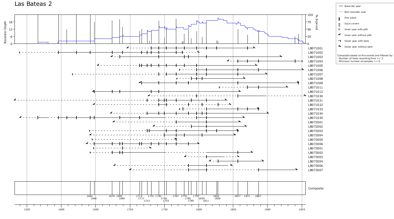
NOAA/WDS Paleoclimatology - Yocom fire data from Las Bateas 2, Sierra Madre Oriental, Coahuila, Mexico - IMPD MXLB-001
National Oceanic and Atmospheric Administration, Department of Commerce —
This archived Paleoclimatology Study is available from the NOAA National Centers for Environmental Information (NCEI), under the World Data Service (WDS) for... -
Federal
SAFARI 2000 Pre- and Post-fire Reflectance near Kaoma, Zambia, Dry Season 2000
National Aeronautics and Space Administration —
The main goal of this study was to analyze the possibility of estimating combustion completeness based on fire-induced spectral reflectance changes of surface... -
Federal
Geospatial data for the Vegetation Mapping Inventory Project of Lassen Volcanic National Park
Department of the Interior —
The files linked to this reference are the geospatial data created as part of the completion of the baseline vegetation inventory project for the NPS park unit.... -
Federal
Imagery data for the Vegetation Mapping Inventory Project of Minidoka National Historic Site
Department of the Interior —
This reference contains the imagery data used in the completion of the baseline vegetation inventory project for the NPS park unit. Orthophotos, raw imagery, and... -
Federal
NOAA/WDS Paleoclimatology - Veblen fire data from BM14 - IMPD USBM-014
National Oceanic and Atmospheric Administration, Department of Commerce —
This archived Paleoclimatology Study is available from the NOAA National Centers for Environmental Information (NCEI), under the World Data Service (WDS) for... -
Federal
Formal Specification and Verification of a Coordination Protocol for an Automated Air Traffic Control System
National Aeronautics and Space Administration —
We detail all of the facets of adapting classical model checking to a real aerospace system, in- cluding deriving the formal model and a set of specifications from... -
Federal
NOAA/WDS Paleoclimatology - Johnson fire data from Pueblo Ridge Central, northern New Mexico - IMPD USPRC001
National Oceanic and Atmospheric Administration, Department of Commerce —
This archived Paleoclimatology Study is available from the NOAA National Centers for Environmental Information (NCEI), under the World Data Service (WDS) for... -
Federal
Imagery data for the Vegetation Mapping Inventory Project of Saugus Iron Works National Historic Site
Department of the Interior —
This reference contains the imagery data used in the completion of the baseline vegetation inventory project for the NPS park unit. Orthophotos, raw imagery, and... -
Federal
NOAA/WDS Paleoclimatology - Veblen fire data from BM3 - IMPD USBM-003
National Oceanic and Atmospheric Administration, Department of Commerce —
This archived Paleoclimatology Study is available from the NOAA National Centers for Environmental Information (NCEI), under the World Data Service (WDS) for... -
Federal
NOAA/WDS Paleoclimatology - Maxwell fire data from New River Gorge National River - IMPD USNRG001
National Oceanic and Atmospheric Administration, Department of Commerce —
This archived Paleoclimatology Study is available from the NOAA National Centers for Environmental Information (NCEI), under the World Data Service (WDS) for...

Official websites use .gov
A
.gov website belongs to an official government
organization in the United States.
Secure .gov websites use HTTPS
A
lock (
) or https:// means you’ve safely connected to
the .gov website. Share sensitive information only on official,
secure websites.