
-
Federal
Nantucket, Massachusetts 1/3 arc-second MHW Coastal Digital Elevation Model recent views
National Oceanic and Atmospheric Administration, Department of Commerce —
NOAA's National Geophysical Data Center (NGDC) is building high-resolution digital elevation models (DEMs) for select U.S. coastal regions. These integrated... -
Federal
Dissolved inorganic carbon (DIC), total alkalinity, water temperature, salinity, nutrients and other variables collected from discrete samples and profile observations during the R/V Celtic Voyager research cruise (EXPOCODE 45CV20190109) in the North Atlantic Ocean, Irish Sea and St. Georges Channel from 2019-01-10 to 2019-01-19 (NCEI Accession 0281869) recent views
National Oceanic and Atmospheric Administration, Department of Commerce —
This NCEI Accession includes discrete profile measurements of dissolved inorganic carbon, total alkalinity, water temperature, salinity, nutrients and other variables... -
Federal
F00761: NOS Hydrographic Survey , 2018-10-25 recent views
National Oceanic and Atmospheric Administration, Department of Commerce —
The National Oceanic and Atmospheric Administration (NOAA) has the statutory mandate to collect hydrographic data in support of nautical chart compilation for safe... -
Federal
F00708: NOS Hydrographic Survey , 2017-10-06 recent views
National Oceanic and Atmospheric Administration, Department of Commerce —
The National Oceanic and Atmospheric Administration (NOAA) has the statutory mandate to collect hydrographic data in support of nautical chart compilation for safe... -
Federal
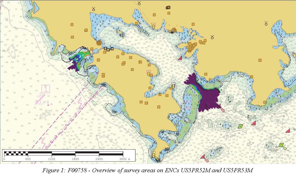
F00758: NOS Hydrographic Survey , 2018-10-30 recent views
National Oceanic and Atmospheric Administration, Department of Commerce —
The National Oceanic and Atmospheric Administration (NOAA) has the statutory mandate to collect hydrographic data in support of nautical chart compilation for safe... -
Federal
F00428: NOS Hydrographic Survey , Approaches Cape Fear River, Wilmington, North Carolina, 1997-05-23 recent views
National Oceanic and Atmospheric Administration, Department of Commerce —
The National Oceanic and Atmospheric Administration (NOAA) has the statutory mandate to collect hydrographic data in support of nautical chart compilation for safe... -
Federal
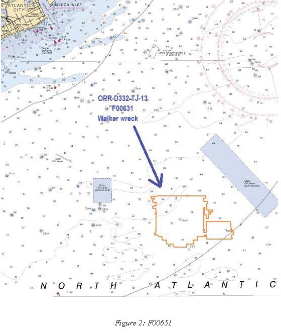
F00631: NOS Hydrographic Survey , Delaware Bay and Approaches, 2013-06-21 recent views
National Oceanic and Atmospheric Administration, Department of Commerce —
The National Oceanic and Atmospheric Administration (NOAA) has the statutory mandate to collect hydrographic data in support of nautical chart compilation for safe... -
Federal
The Coral Reef Temperature Anomaly Database (CoRTAD) Version 3 - Global, 4 km Sea Surface Temperature and Related Thermal Stress Metrics for 1982-2009 (NODC Accession 0068999) recent views
National Oceanic and Atmospheric Administration, Department of Commerce —
The Coral Reef Temperature Anomaly Database (CoRTAD) is a collection of sea surface temperature (SST) and related thermal stress metrics, developed specifically for... -
Federal
The Coral Reef Temperature Anomaly Database (CoRTAD) Version 1 - Global, 4 km, Sea Surface Temperature and Related Thermal Stress Metrics for 1985-2005 (NODC Accession 0044419) recent views
National Oceanic and Atmospheric Administration, Department of Commerce —
The Coral Reef Temperature Anomaly Database (CoRTAD) is a collection of sea surface temperature (SST) and related thermal stress metrics, developed specifically for... -
Federal
The Coral Reef Temperature Anomaly Database (CoRTAD) Version 4 - Global, 4 km Sea Surface Temperature and Related Thermal Stress Metrics for 1981-10-31 to 2010-12-31 (NODC Accession 0087989) recent views
National Oceanic and Atmospheric Administration, Department of Commerce —
The Coral Reef Temperature Anomaly Database (CoRTAD) is a collection of sea surface temperature (SST) and related thermal stress metrics, developed specifically for... -
Federal
The Coral Reef Temperature Anomaly Database (CoRTAD) Version 2 - Global, 4 km Sea Surface Temperature and Related Thermal Stress Metrics for 1982-2008 (NODC Accession Number 0054501) recent views
National Oceanic and Atmospheric Administration, Department of Commerce —
The Coral Reef Temperature Anomaly Database (CoRTAD) is a collection of sea surface temperature (SST) and related thermal stress metrics, developed specifically for... -
Federal
EX2107: Windows to the Deep 2021: Southeast U.S. (ROV and Mapping) recent views
National Oceanic and Atmospheric Administration, Department of Commerce —
The Windows to the Deep 2021: Southeast U.S. ROV and Mapping expedition (EX-21-07) was a combined mapping and remotely operated vehicle (ROV) expedition to the Blake... -
Federal
South Atlantic Bight Habitat Mapping on NOAA Ship Nancy Foster in North Atlantic Ocean between 20070626 and 20070702 recent views
National Oceanic and Atmospheric Administration, Department of Commerce —
This expedition on the NOAA Ship Nancy Foster used the recently-developed National Undersea Research Center for the North Atlantic and Great Lakes (NURC-NAGL) ROV... -
Federal
EX2103: 2021 ROV Shakedown (ROV & Mapping) recent views
National Oceanic and Atmospheric Administration, Department of Commerce —
This Remotely Operated Vehicle (ROV) shakedown expedition aboard NOAA Ship Okeanos Explorer began in Norfolk, Virginia on June 13, 2021 and concluded on June 28, 2021... -
Federal
Cetacean visual observations using line-transect survey methods onboard the NOAA Ship Gordon Gunter (GU) during the Atlantic Marine Assessment Program for Protected Species (AMAPPS) in the Western North Atlantic Ocean (survey GU2301) from 2023-02-04 to 2023-04-27. (NCEI Accession 0290563) recent views
National Oceanic and Atmospheric Administration, Department of Commerce —
As part of the Atlantic Marine Assessment Program for Protected Species (AMAPPS), the Southeast Fisheries Science Center (SEFSC) conducted a shipboard survey of the... -
Federal
Dissolved inorganic carbon, total alkalinity, water temperature, salinity, nutrients and other parameters collected from profile and discrete sample observations during R/V Johan Hjort and other research ships time series cruises in the North Atlantic Ocean, Norwegian See from 2011-01-13 to 2017-04-02 (NCEI Accession 0282292) recent views
National Oceanic and Atmospheric Administration, Department of Commerce —
This dataset includes discrete profile measurements of dissolved inorganic carbon (DIC), total alkalinity, water temperature, salinity, nutrients and other parameters... -
Federal
2019 NOAA NGS Ortho-rectified 4 band Mosaic of U.S. Virgin Islands recent views
National Oceanic and Atmospheric Administration, Department of Commerce —
The source imagery was acquired from 20190413 - 20191208 using two camera systems: Vexcel UltraCam Falcon M2 and Vexcel UltraCam LP. The original images were acquired... -
Federal
Shoreline Data Rescue Project of Point Vacia Talegas to Point Viento, PR, PR1901A NGDA recent views
National Oceanic and Atmospheric Administration, Department of Commerce —
These data were automated to provide an accurate high-resolution historical shoreline of Point Vacia Talegas to Point Viento, PR suitable as a geographic information... -
Federal
Shoreline Mapping Program of Southern Puerto Rico, Punta Verraco to Cabo Mala Pascua, PR, PR1401B-TB-N NGDA recent views
National Oceanic and Atmospheric Administration, Department of Commerce —
These data provide an accurate high-resolution shoreline compiled from imagery of Southern Puerto Rico, Punta Verraco to Cabo Mala Pascua, PR . This vector shoreline... -
Federal
2019 NOAA NGS Ortho-rectified 4 band Mosaic of Puerto Rico recent views
National Oceanic and Atmospheric Administration, Department of Commerce —
This data set is 3672 ortho-rectified mosaic tiles, created as a product from the NOAA Integrated Ocean and Coastal Mapping (IOCM) initiative. The source imagery was...

Official websites use .gov
A
.gov website belongs to an official government
organization in the United States.
Secure .gov websites use HTTPS
A
lock (
) or https:// means you’ve safely connected to
the .gov website. Share sensitive information only on official,
secure websites.
.jpg)