
-
Federal
OCO-2 Level 1A collated, parsed, science or calibration data, Retrospective Processing V11r (OCO2_L1aIn_Sample) at GES DISC
National Aeronautics and Space Administration —
Version 11r is the current version of the data set. Older versions will no longer be available and are superseded by Version 11r. The Orbiting Carbon Observatory is... -
Federal
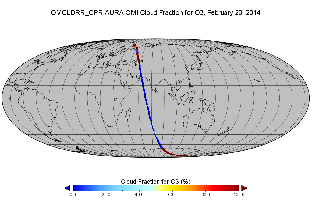
OMI/Aura Cloud Pressure and Fraction (Raman Scattering) 200-km swath subset along CloudSat track V003 (OMCLDRR_CPR) at GES DISC
National Aeronautics and Space Administration —
This is the OMI/Aura Cloud Pressure and Fraction (Raman Scattering) subset along CloudSat tracks, for the purposes of the A-Train mission. The original data product... -
Federal
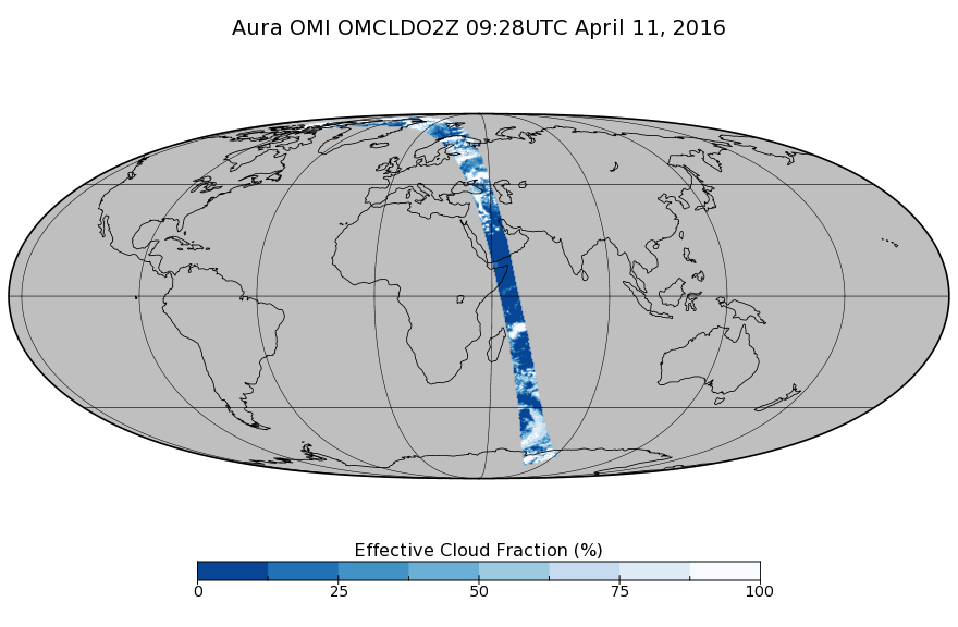
OMI/Aura Cloud Pressure and Fraction (O2-O2 Absorption) Zoomed 1-Orbit L2 Swath 13x12km V003 (OMCLDO2Z) at GES DISC
National Aeronautics and Space Administration —
The reprocessed Aura Ozone Monitoring Instrument (OMI) Level-2 zoomed cloud data product OMCLDO2Z at 13x12 km resolution is now available from the NASA Goddard Earth... -
Federal
OCO-3 Level 2 CO2 prior based on CO2 monthly flask record, global meteorology, and age of air, Retrospective Processing V11r (OCO3_L2_CO2Prior) at GES DISC
National Aeronautics and Space Administration —
Version 11r is the current version of the data set. Older versions will no longer be available and are superseded by Version 11r. The Orbiting Carbon Observatory -3... -
Federal
OCO-3 Level 2 spatially ordered geolocated retrievals screened using the A-band Preprocessor, Forward Processing V10 (OCO3_L2_ABand) at GES DISC
National Aeronautics and Space Administration —
Version 10 is the current version of the data set. Older versions will no longer be available and are superseded by Version 10. The Orbiting Carbon Observatory -3... -
Federal
OCO-3 Level 1B calibrated, geolocated calibration spectra, Retrospective Processing V10r (OCO3_L1B_Calibration) at GES DISC
National Aeronautics and Space Administration —
Version 10r is the current version of the data set. Older versions will no longer be available and are superseded by Version 10r. The Orbiting Carbon Observatory -3... -
Federal
OCO-3 Level 1B calibrated, geolocated calibration spectra, Retrospective Processing V11r (OCO3_L1B_Calibration) at GES DISC
National Aeronautics and Space Administration —
Version 11r is the current version of the data set. Older versions will no longer be available and are superseded by Version 11r. The Orbiting Carbon Observatory -3... -
Federal
OCO-3 Level 1B calibrated, geolocated science spectra, Forward Processing V10 (OCO3_L1B_Science) at GES DISC
National Aeronautics and Space Administration —
Version 10 is the current version of the data set. Older versions will no longer be available and are superseded by Version 10. The Orbiting Carbon Observatory -3... -
Federal
Northwest Atlantic and northeast Pacific oceans measurements collected during Sea Education Association (SEA) cruises
National Aeronautics and Space Administration —
Measurements made in the northwest Atlantic and northeast Pacific oceans between 2008 and 2009. -
Federal
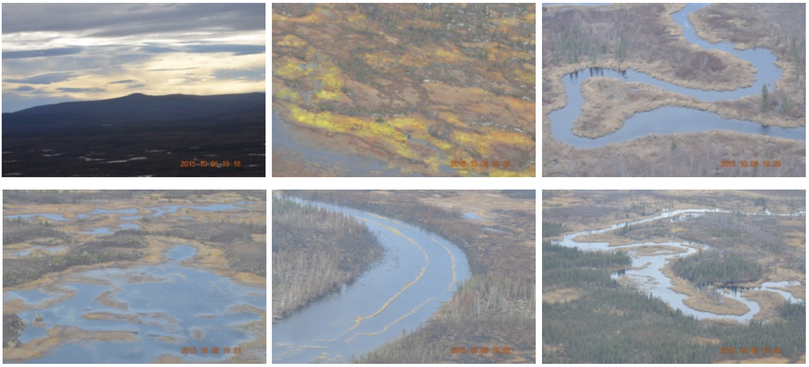
CARVE: In-flight Photos from the CARVE Aircraft, Alaska, 2013-2015
National Aeronautics and Space Administration —
This dataset contains photos taken by scientists aboard the CARVE aircraft during airborne campaigns over the Alaskan and Canadian Arctic for the Carbon in Arctic... -
Federal
CERES Time-Interpolated TOA Fluxes, Clouds and Aerosols Monthly Aqua Edition4A
National Aeronautics and Space Administration —
CER_SSF1deg-Month_Aqua-MODIS_Edition4A is the Clouds and the Earth's Radiant Energy System (CERES) Time-Interpolated Top of Atmosphere (TOA) Fluxes, Clouds and... -
Federal
BOREAS TF-11 Decomposition Data over the SSA-Fen
National Aeronautics and Space Administration —
The BOREAS TF-11 team collected several data sets in their efforts to fully describe the flux and site characteristics at the SSA-Fen site. This data set contains... -
Federal
CATS-ISS Level 1B Day Mode 7.2 Version 3-00
National Aeronautics and Space Administration —
CATS-ISS_L1B_D-M7.2-V3-00 is the Cloud-Aerosol Transport System (CATS) International Space Station (ISS) Level 1B Day Mode 7.2 Version 3-00 data product. This... -
Federal
SMAP_L1A_RADAR_QA_V001
National Aeronautics and Space Administration —
SMAP Level 1A Radar Data Quality Information -
Federal
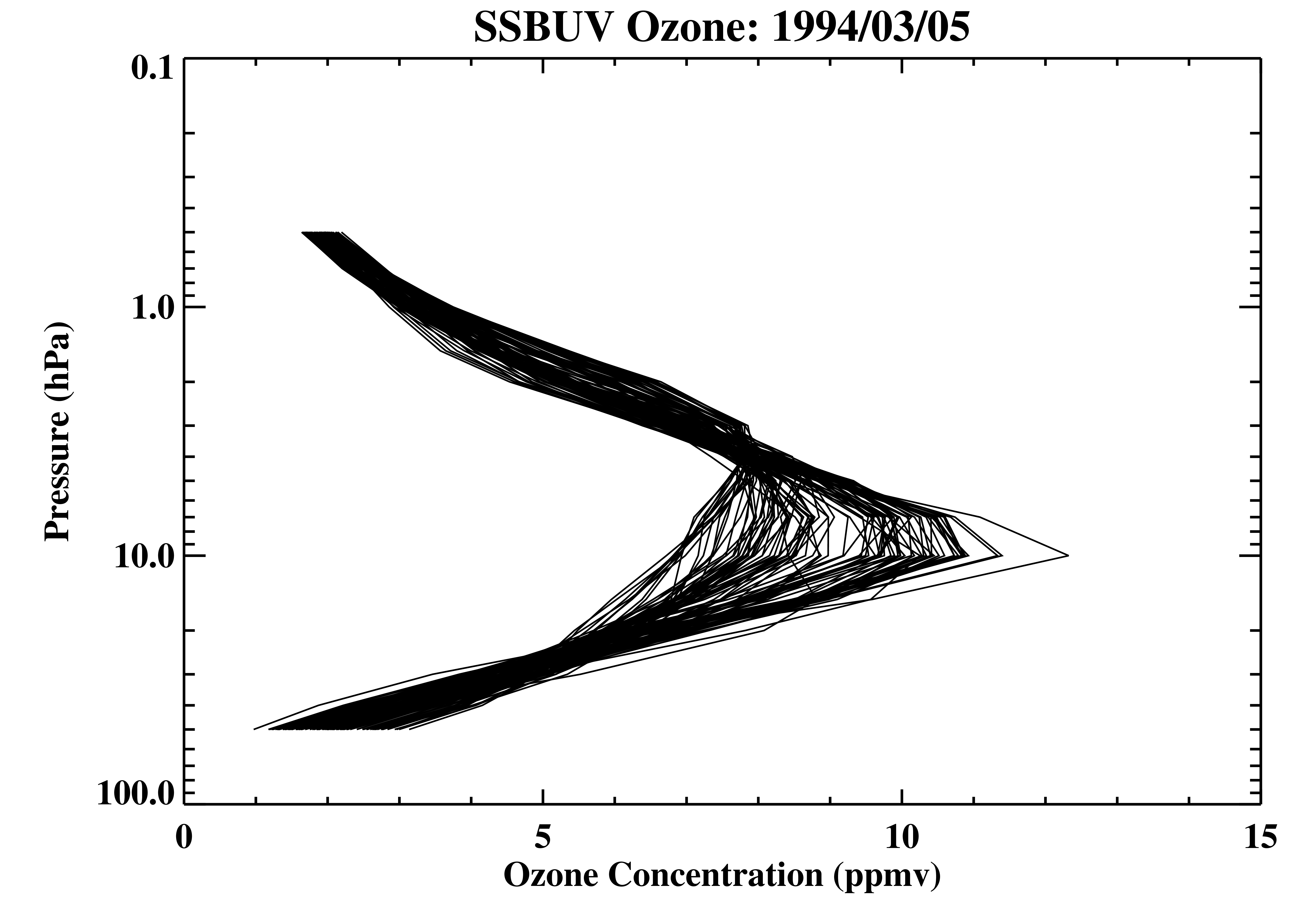
Shuttle SBUV (SSBUV) Level 2 Ozone Profile and Total Column, Aerosol Index, and UV-Reflectivity V008 (SSBUVO3) at GES DISC
National Aeronautics and Space Administration —
The Shuttle Solar Backscatter Ultraviolet (SSBUV) Level-2 Ozone data are available for eight space shuttle missions flown between 1989 and 1996. SSBUV, a successor to... -
Federal
Sentinel-6A MF Jason-CS L2 P4 Altimeter Low Resolution (LR) STC Reduced Ocean Surface Topography
National Aeronautics and Space Administration —
Provides low resolution (LR) short time critical (STC; 36-hour latency) measurements of sea surface height anomaly (SSHA), Significant Wave Height (SWH), and Wind... -
Federal
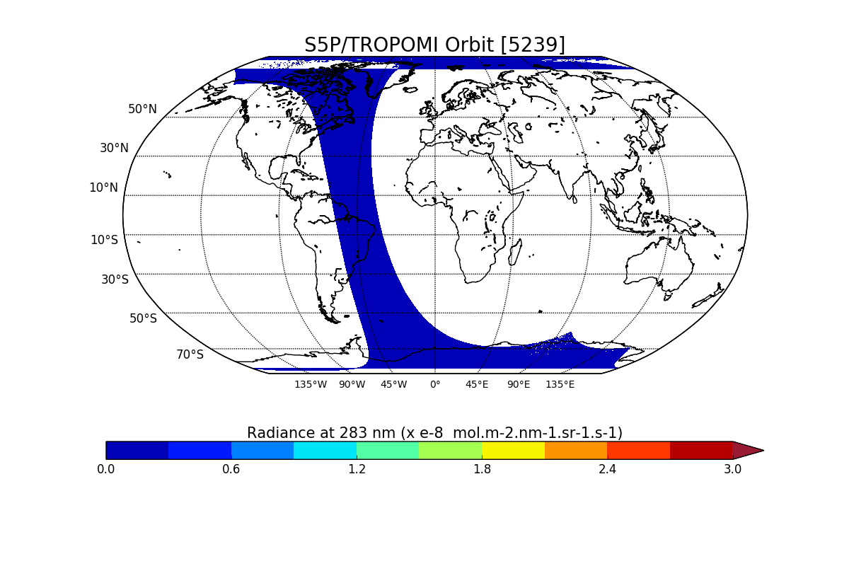
Sentinel-5P TROPOMI Radiance product band 1 (UV detector) L1B V1 (S5P_L1B_RA_BD1) at GES DISC
National Aeronautics and Space Administration —
Starting from August 6th in 2019, Sentinel-5P TROPOMI along-track high spatial resolution (~5.5km at nadir) has been implemented. For data after August 6th of 2019,... -
Federal
Measurements onboard the Russian R/V Akademik Sergey Vavilov
National Aeronautics and Space Administration —
Measurements from the Barents Sea north of Russia made during 1998 by the Russian research vessel, the Akademik Sergey Vavilov.

Official websites use .gov
A
.gov website belongs to an official government
organization in the United States.
Secure .gov websites use HTTPS
A
lock (
) or https:// means you’ve safely connected to
the .gov website. Share sensitive information only on official,
secure websites.