
-
Federal
DISCOVER-AQ Maryland Deployment Edgewood Ground Site Data
National Aeronautics and Space Administration —
DISCOVERAQ_Maryland_Ground_Edgewood_Data contains data collected at the Edgewood ground site during the Maryland (Baltimore-Washington) deployment of NASA's DISCOVER-... -
Federal
MODIS/Terra Water Reservoir 8-Day L3 Global V061
National Aeronautics and Space Administration —
The Terra Moderate Resolution Imaging Spectroradiometer (MODIS) Water Reservoir 8-Day Level 3 (L3) Global (MOD28C2) Version 6.1 product provides current data for 151... -
Federal
Carbon Monitoring System Carbon Flux FossilFuel Prior L4 V3 (CMSFluxFossilFuelPrior)
National Aeronautics and Space Administration —
This dataset provides the Prior for the Fossil Fuel Carbon Flux. The NASA Carbon Monitoring System (CMS) is designed to make significant contributions in... -
Federal
ABoVE: Landsat Tundra Greenness and Summer Air Temperatures, Arctic Tundra, 1985-2016
National Aeronautics and Space Administration —
This dataset provides annual tundra greenness and summer air temperatures at a resolution of 50 km over the pan-Arctic tundra biome above 31.5 degrees over the time... -
Federal
GOES-R PLT Mission Reports
National Aeronautics and Space Administration —
The GOES-R PLT Mission Reports dataset consists of various reports filed by the scientists during the GOES-R Post Launch Test (PLT) field campaign including flight... -
Federal
SEASAT SCATTEROMETER DEALIASED OCEAN WIND VECTORS (JPL-UCLA-AES)
National Aeronautics and Space Administration —
Contains dealiased ocean wind vector components (zonal and meridional) derived from the Seasat-A Scatterometer (SASS) provided on a global 1x1 degree grid. Dealiasing... -
Federal
ABoVE: Historical Lake Shorelines and Areas near Fairbanks, Alaska from 1949-2009
National Aeronautics and Space Administration —
This dataset includes maps of historical lake shorelines with derived lake areas in the southern portion of the Goldstream Valley and the surrounding landscape north... -
Federal
ECOSTRESS Attitude Daily L1B Global 70m V001
National Aeronautics and Space Administration —
The ECO1BATT Version 1 data product was decommissioned on April 22, 2025. Users are encouraged to use theFederalOPERA Land Surface Disturbance Alert from Harmonized Landsat Sentinel-2 product (Version 1)
National Aeronautics and Space Administration —
The Observational Products for End-Users from Remote Sensing Analysis (OPERA) Land Surface Disturbance Alert from...FederalCSR TELLUS GRACE-FO Level-3 Monthly Ocean Bottom Pressure Anomaly Release 6.3 version 04
National Aeronautics and Space Administration —
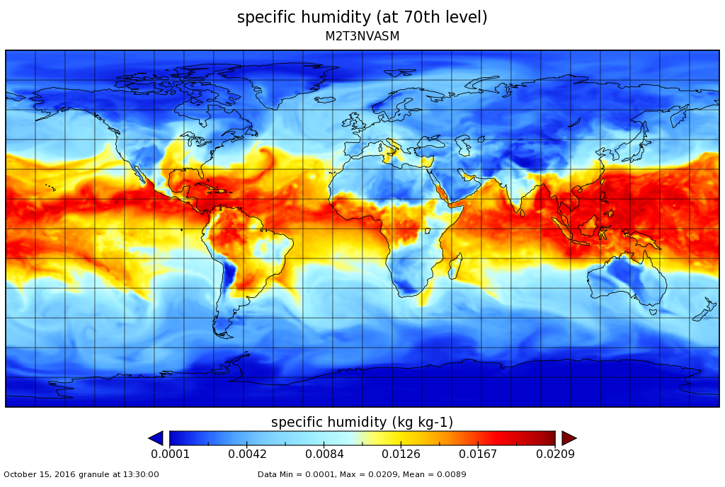
This data set is produced by the Center for Space Research (CSR) GRACE-FO (Gravity Recovery and Climate Experiment Follow-On) program and derives the ocean bottom...FederalMERRA-2 tavg3_3d_asm_Nv: 3d,3-Hourly,Time-Averaged,Model-Level,Assimilation,Assimilated Meteorological Fields 0.625 x 0.5 degree V5.12.4 (M2T3NVASM) at GES DISC
National Aeronautics and Space Administration —
M2T3NVASM (or tavg3_3d_asm_Nv) is a 3-dimensional 3-hourly time averaged data collection in Modern-Era Retrospective analysis for Research and Applications version 2...FederalBOREAS TE-11 Leaf Gas Exchange Measurements
National Aeronautics and Space Administration —
The BOREAS TE-11 team collected several data sets in support of its efforts to characterize and interpret information on the sapflow, gas exchange, and lichen...FederalCALIPSO Lidar Level 2 1/3 km Merged Layer, V4-51
National Aeronautics and Space Administration —
CAL_LID_L2_333mMLay-Standard-V4-51 is the Cloud-Aerosol Lidar and Infrared Pathfinder Satellite Observation (CALIPSO) Lidar Level 2 333 m Merged (cloud + aerosol)...FederalLBA-ECO LC-15 Vegetation Cover Types from MODIS, 1-km, Amazon Basin: 2000-2001
National Aeronautics and Space Administration —
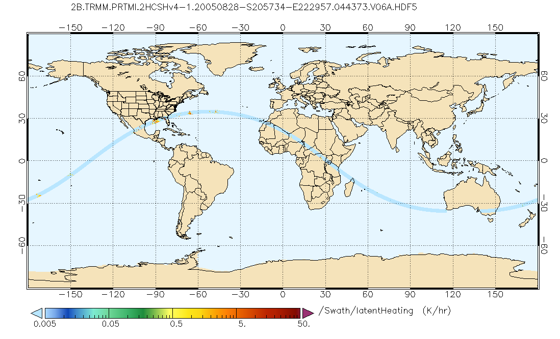
This data set contains proportional estimates for the vegetative cover types of woody vegetation, herbaceous vegetation, and bare ground over the Amazon Basin for the...FederalGPM PR and TMI on TRMM Combined Convective-Stratiform Latent Heating Profiles L2 1.5 hours 5 km V07 (GPM_2HCSH_TRMM) at GES DISC
National Aeronautics and Space Administration —
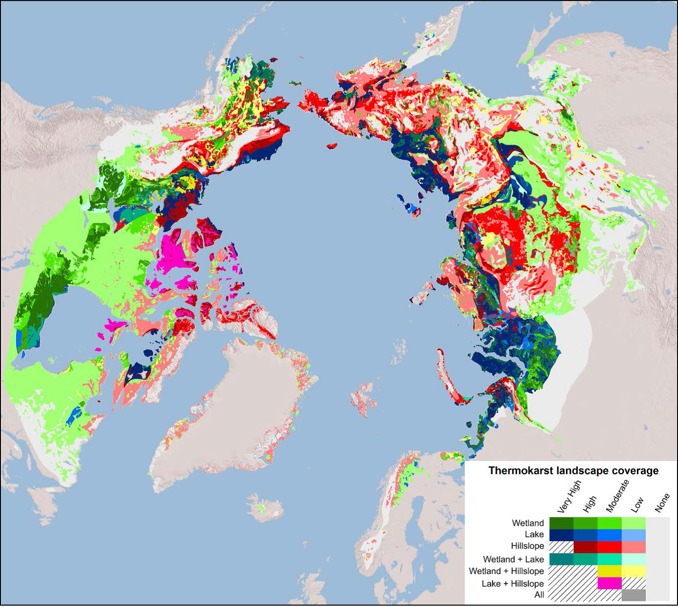
This is a new (GPM-formated) TRMM product. The equivalent old TRMM legacy product is TRMM_2H31. Version 07 is the current version of the data set. Older versions will...FederalArctic Circumpolar Distribution and Soil Carbon of Thermokarst Landscapes, 2015
National Aeronautics and Space Administration —
This data set provides the distribution of thermokarst landscapes in the boreal and tundra ecoregions within the northern circumpolar permafrost zones. This dataset...FederalAqua/AIRS L3 Daily Standard Physical Retrieval (AIRS-only) 1 degree x 1 degree V7.0 at GES DISC
National Aeronautics and Space Administration —
The Atmospheric Infrared Sounder (AIRS) is a grating spectrometer (R = 1200) aboard the second Earth Observing System (EOS) polar-orbiting platform, EOS Aqua. The...FederalCMS: Aboveground Biomass from Penobscot Experimental Forest, Maine, 2012
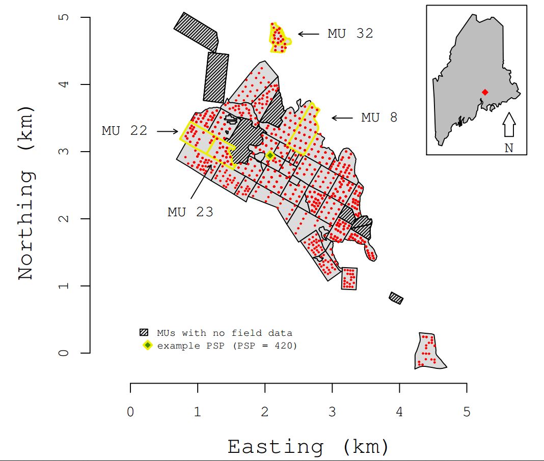
National Aeronautics and Space Administration —
This data set includes estimates of aboveground biomass (AGB) in 2012 from the Penobscot Experimental Forest (PEF) in Bradley, Maine. The AGB was modeled using LiDAR...FederalNASADEM SRTM Image Mosaic Global 1 arc second V001
National Aeronautics and Space Administration —
The Land Processes Distributed Active Archive Center (LP DAAC) is responsible for the archive and distribution of NASA Making Earth System Data Records for Use in...9,585 datasets found

Official websites use .gov
A
.gov website belongs to an official government
organization in the United States.
Secure .gov websites use HTTPS
A
lock (
) or https:// means you’ve safely connected to
the .gov website. Share sensitive information only on official,
secure websites.