
-
Federal
FIREX-AQ NOAA-CHEM Twin Otter In Situ Trace Gas Data
National Aeronautics and Space Administration —
FIREXAQ_TraceGas_AircraftInSitu_N48_Data are in situ trace gas data collected onboard the NOAA-CHEM Twin Otter during FIREX-AQ. This product features data collected... -
Federal
GEOS-Carb CASA-GFED Daily Fire and Fuel Emissions 0.5 degree x 0.5 degree V2 (GEOS_CASAGFED_D_FIRE) at GES DISC
National Aeronautics and Space Administration —
This product provides Daily average wildfire emissions (FIRE) andfuel wood burning emissions (FUEL) derived from the Carnegie-Ames-Stanford-Approach – Global Fire... -
Federal
Eddy Corr. Surface Flux: ANL (FIFE)
National Aeronautics and Space Administration —
The Eddy Correlation Surface Flux Observations (Argonne) Data Set contains surface flux measurements made at selected sites within the FIFE study area. The surface... -
Federal
ROSETTA-ORBITER 67P OSIWAC 3 PRL-MTP004 RDR V3.0
National Aeronautics and Space Administration —
This CODMAC level 3 data set contains radiometric calibrated image data in W/m^2/sr/nm, acquired by the OSIRIS Wide Angle Camera on the Rosetta spacecraft during the... -
Federal
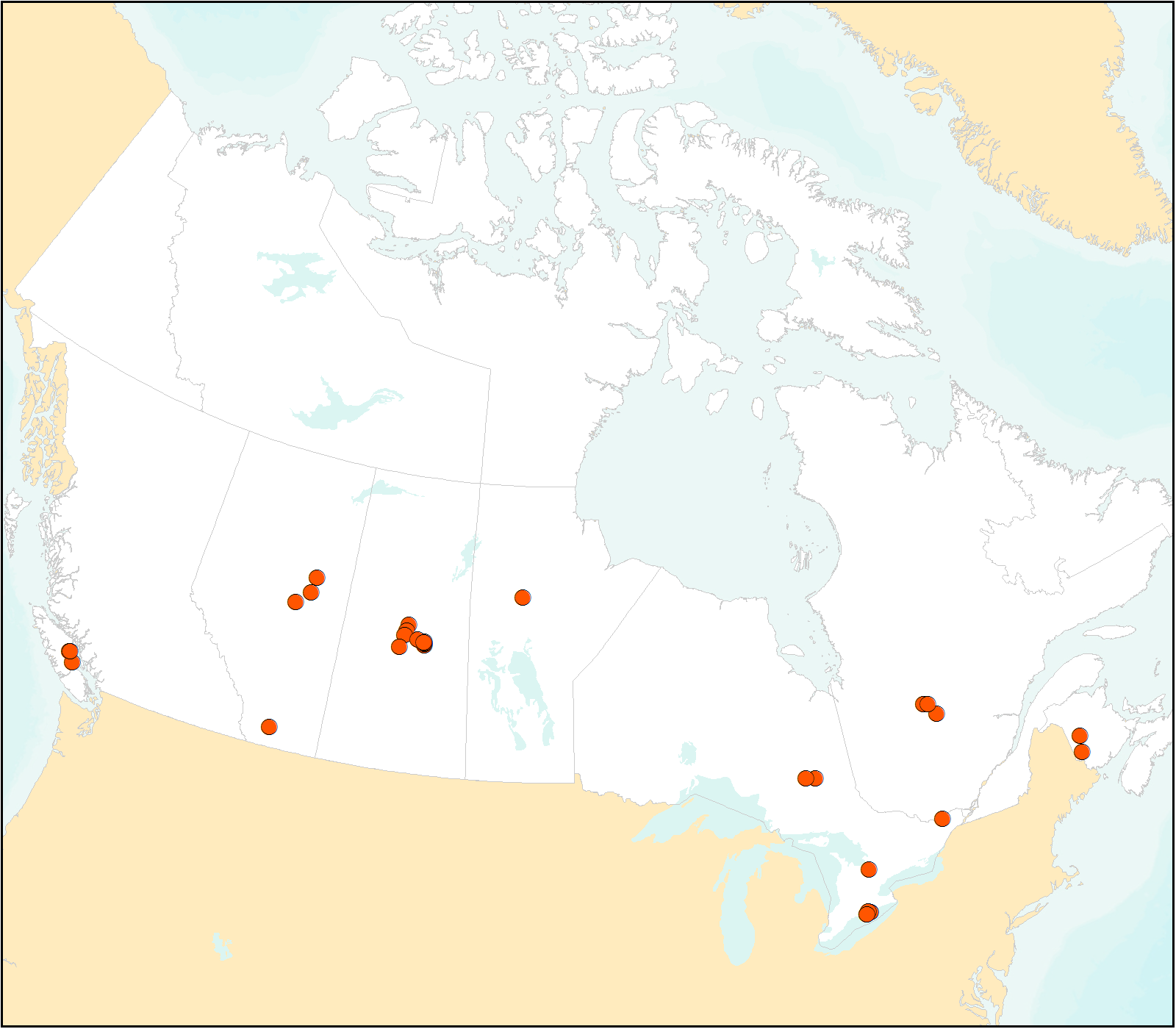
FLUXNET Canada Research Network - Canadian Carbon Program Data Collection, 1993-2014
National Aeronautics and Space Administration —
FLUXNET Canada is a Fluxnet research network comprised of the Fluxnet-Canada Research Network (FCRN) and the Canadian Carbon Program (CCP) operating from 1993 through... -
Federal
AIRS/Aqua L3 8-day CO2 in the free troposphere (AIRS+AMSU) 2.5 degrees x 2 degrees V005 (AIRX3C28) at GES DISC
National Aeronautics and Space Administration —
Atmospheric Infrared Sounder (AIRS) is a grating spectrometer (R = 1200) aboard the second Earth Observing System (EOS) polar-orbiting platform, EOS Aqua. In... -
Federal
Shoreline Data Rescue Project of Chowan River from Meherrin River to Colerain Landing, North Carolina, EC11E04 NGDA
National Oceanic and Atmospheric Administration, Department of Commerce —
These data were automated to provide an accurate high-resolution historical shoreline of Chowan River from Meherrin River to Colerain Landing, North Carolina suitable... -
Federal
MLS/Aura Level 2 Carbon Monoxide (CO) Mixing Ratio V004 (ML2CO) at GES DISC
National Aeronautics and Space Administration —
ML2CO is the EOS Aura Microwave Limb Sounder (MLS) standard product for carbon monoxide derived from radiances measured by the 640 GHz radiometer. The data version is... -
Federal
IceBridge HiCARS 2 L0 Raw Return Energy Amplitudes, Version 1
National Aeronautics and Space Administration —
This data set contains radar sounder measurements taken over Antarctica using the Hi-Capability Radar Sounder (HiCARS) Version 2 instrument. The data were collected... -
Federal
DISCOVER-AQ Colorado Deployment Platteville Ground Site Data
National Aeronautics and Space Administration —
DISCOVERAQ_Colorado_Ground_Platteville_Data contains data collected at the Platteville ground site during the Colorado (Denver) deployment of NASA's DISCOVER-AQ field... -
Federal
Eddy Corr. Surface Flux: UNL (FIFE)
National Aeronautics and Space Administration —
Surface flux and micrometeorological measurements were collected at one site within the northwest quadrant near the center of the FIFE study area during all five of... -
Federal
DISCOVER-AQ Maryland Deployment Oldtown Ground Site Data
National Aeronautics and Space Administration —
DISCOVERAQ_Maryland_Ground_Oldtown_Data contains data collected at the Oldtown ground site during the Maryland (Baltimore-Washington) deployment of NASA's DISCOVER-AQ... -
Federal
DC3 In-Situ NSF/NCAR GV-HIAPER Trace Gas Data
National Aeronautics and Space Administration —
DC3_TraceGas_AircraftInSitu_NSF-GV-HIAPER_Data are in-situ trace gas data collected onboard the NSF/NCAR GV-HIAPER aircraft during the Deep Convective Clouds and... -
Federal
CARVE: L2 Atmospheric CO2, CO and CH4 Concentrations, NOAA CRDS, Alaska, 2012-2015
National Aeronautics and Space Administration —
This data set provides atmospheric carbon dioxide (CO2), methane (CH4), carbon monoxide (CO), and water vapor (H2O) concentrations from airborne campaigns over the... -
Federal
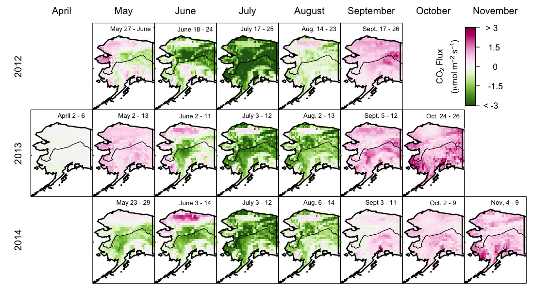
CARVE: Net Ecosystem CO2 Exchange and Regional Carbon Budgets for Alaska, 2012-2014
National Aeronautics and Space Administration —
This data set provides estimates of 3-hourly net ecosystem CO2 exchange (NEE) at 0.5-degree resolution over the state of Alaska for 2012-2014. The NEE estimates are... -
Federal
BOREAS TF-11 SSA-FEN Tower Flux and Meteorological Data
National Aeronautics and Space Administration —
The BOREAS TF-11 team collected energy, carbon dioxide, and methane flux data at the BOREAS SSA-Fen site during the growing seasons of 1994 and 1995. -
Federal
BOREAS TF-11 SSA Fen 1996 Water Surface Film Capping Data
National Aeronautics and Space Administration —
The BOREAS TF-11 team gathered a variety of data to complement their tower flux measurements collected at the SSA Fen site. The data described in this document were... -
Federal
Data describing site characteristics including conifer regeneration following the 2018 Carr Fire in Whiskeytown National Recreation Area
Department of the Interior —
This dataset provides seedling density and site characteristics for 131 plots in Whiskeytown National Recreation area in California, USA. Site characteristics include... -
Federal
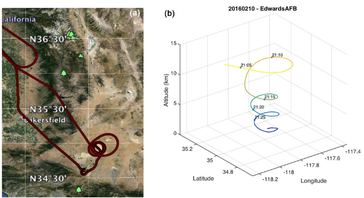
ASCENDS: Active Sensing of CO2 With AVOCET, California and Nevada, 2016
National Aeronautics and Space Administration —
This dataset provides in situ airborne measurements of atmospheric carbon dioxide (CO2) over California and Nevada on February 10-11, 2016. Measurements were taken...

Official websites use .gov
A
.gov website belongs to an official government
organization in the United States.
Secure .gov websites use HTTPS
A
lock (
) or https:// means you’ve safely connected to
the .gov website. Share sensitive information only on official,
secure websites.