
-
Federal
John H. Chafee Foster Care Program for Successful Transition to Adulthood
U.S. Department of Health & Human Services —
The John H. Chafee Foster Care Program for Successful Transition to Adulthood (the Chafee program) provides funding to support youth/ young adults in or formerly in... -
Federal
Dissolved inorganic carbon (DIC) and total alkalinity (TA) and other hydrographic and chemical data collected from discrete sample and profile observations during the R/V Sikuliaq cruise SKQ202412s (EXPOCODE 33BI20240807) in the Bering and Chukchi Sea along transect lines in the Distributed Biological Observatory (DBO) from 2024-08-07 to 2024-08-26 (NCEI Accession 0304116)
National Oceanic and Atmospheric Administration, Department of Commerce —
This dataset includes hydrographic and chemical data collected from discrete sample and profile observations during the R/V Sikuliaq cruise SKQ202412s (EXPOCODE... -
Federal
US EPA Nonattainment Areas and Designations - Download Package
U.S. Environmental Protection Agency —
This downloadable data package contains the following state level layers: Ozone 8-hr (1997 standard), Ozone 8-hr (2008 standard), Lead (2008 standard), SO2 1-hr (2010... -
State
MD iMAP: Maryland Research Reserves - Chesapeake Bay National Estuarine Research Reserves
State of Maryland —
This is a MD iMAP hosted service. Find more information at http://imap.maryland.gov. The National Estuarine Research Reserve System (NERRS) is a network of protected... -
Federal
H13510: NOS Hydrographic Survey , 2021-09-06
National Oceanic and Atmospheric Administration, Department of Commerce —
The National Oceanic and Atmospheric Administration (NOAA) has the statutory mandate to collect hydrographic data in support of nautical chart compilation for safe... -
State
MD iMAP: Maryland Archived MD Environmental Trust 2010 Land Acquisitions Detail
State of Maryland —
This is a MD iMAP hosted service. Find more information on http://imap.maryland.gov. The Maryland Environmental Trust (MET) is a statewide local land trust governed... -
State
MD iMAP: Maryland Wetlands - Wetlands Polygon (Special State Concern)
State of Maryland —
This is a MD iMAP hosted service layer. Find more information at http://imap.maryland.gov. In Maryland certain wetlands with rare - threatened - endangered species or... -
Federal
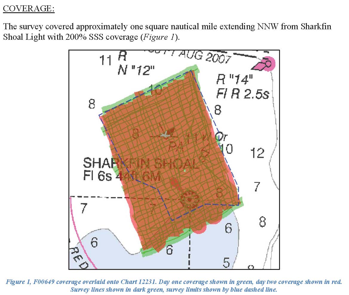
F00649: NOS Hydrographic Survey , 2014-10-17
National Oceanic and Atmospheric Administration, Department of Commerce —
The National Oceanic and Atmospheric Administration (NOAA) has the statutory mandate to collect hydrographic data in support of nautical chart compilation for safe... -
State
MD iMAP: Maryland Water Quality - Tier II High Quality Waters 2012
State of Maryland —
This is a MD iMAP hosted service layer. Find more information at http://imap.maryland.gov. The intent of this dataset is for it to be used to produce maps and provide... -
Federal
Physical Oceanographic (Water Temperature and Conductivity) Data
National Oceanic and Atmospheric Administration, Department of Commerce —
NOAA's Center for Operational Oceanographic Products and Services (CO-OPS) is the authoritative source for accurate, reliable, and timely data on tides, water levels,... -
State
MD iMAP: Maryland US National Grid Zone 17S - US National Grid Zone 17S (1000m)
State of Maryland —
This is a MD iMAP hosted service layer. Find more information at http://imap.maryland.gov. This is a MGRS 1km Square Identifier polygon shapefile. The polygons are... -
Capital Area Food Bank Emergency Food Provider
District of Columbia —
Points in this layer represent the locations of Capital Area Food Bank (CAFB) programs and public partners in the DMV (DC, Maryland, and Virginia). Data were compiled... -
Federal
H13507: NOS Hydrographic Survey , 2021-06-25
National Oceanic and Atmospheric Administration, Department of Commerce —
The National Oceanic and Atmospheric Administration (NOAA) has the statutory mandate to collect hydrographic data in support of nautical chart compilation for safe... -
Federal
Discrete bottle samples of dissolved inorganic carbon (DIC), total Alkalinity (TA), pH on total scale and salinity, made at two locations near Chesapeake Biological Laboratory from 2021-06-23 to 2021-07-06 (NCEI Accession 0303110)
National Oceanic and Atmospheric Administration, Department of Commerce —
This dataset contains the discrete bottle data collected at two locations in the vicinity of an oyster aquaculture facility at the Chesapeake Biological Laboratory in... -
Federal
Full resolution and low resolution real-time physical trajectory profile data from gliders submitted to NCEI by the IOOS National Glider Data Assembly Center (NGDAC) from 2009-05-17 to present
National Oceanic and Atmospheric Administration, Department of Commerce —
This collection includes full resolution and low resolution real-time physical trajectory profile data from gliders deployed by various institutions in seas world-... -
State
MD iMAP: Maryland Watersheds - 8 Digit Watersheds
State of Maryland —
This is a MD iMAP hosted service layer. Find more information at http://imap.maryland.gov. This file (SWSUB8) is a statewide digital watershed file. It depicts the... -
Federal
TIGER/Line Shapefile, 2018, nation, U.S., Current County and Equivalent National Shapefile
U.S. Census Bureau, Department of Commerce —
The TIGER/Line shapefiles and related database files (.dbf) are an extract of selected geographic and cartographic information from the U.S. Census Bureau's Master... -
Federal
Water mass ages based on GLODAPv2 data product (NCEI Accession 0226793)
National Oceanic and Atmospheric Administration, Department of Commerce —
This dataset contain ventilation ages calculated using the transit time distribution (TTD) method (e.g., Waugh et al., 2004) on the GLODAPv2 data synthesis product... -
State
MD iMAP: Maryland Archived ACS ZIP Code
State of Maryland —
This is a MD iMAP hosted service. Find more information on http://imap.maryland.gov. The American Community Survey (ACS) is a nationwide - continuous survey designed... -
Aerial Photography (Orthophoto) - 2019
District of Columbia —
2019 Orthophoto - 3 inch resolution imagery service. Data produced for the District of Columbia from 2019 digital aerial photography. Flight took place on April 23rd,...

Official websites use .gov
A
.gov website belongs to an official government
organization in the United States.
Secure .gov websites use HTTPS
A
lock (
) or https:// means you’ve safely connected to
the .gov website. Share sensitive information only on official,
secure websites.