

173 datasets found for "毕设ssm382航帆学院网站+vue毕业设计✅项目合作 二开均可 TG:saolei44✅.qCuGtRwRmYo"
-
Federal
Funding API Updated
Department of Justice —
Funding API filtering out the "No Award" for Status from the original "Funding" dataset with the URL: https://data.ojp.usdoj.gov/Funding-API/Funding/a7v8-ei2f... -
Federal
Data associated with manuscript "Linearizing the vertical scale of an interferometric microscope and its effect on step-height measurement"
National Institute of Standards and Technology —
This repository contains all of the data used in the manuscript "Linearizing the vertical scale of an interferometric microscope and its effect on step-height... -
City
Historical Medallion Drivers – Passenger Assistance Trained 2014-2016
City of New York —
This list contains information on the status of current medallion drivers who had completed Passenger Assistance Training. This list is accurate to the date and time... -
Federal
GPM Ground Validation Duke Rain Gauges IPHEx
National Aeronautics and Space Administration —
The GPM Ground Validation Duke Rain Gauge data were collected during the GPM Ground Validation Integrated Precipitation and Hydrology Experiment (IPHEx) field... -
Federal
SnowEx20-21 QSI Lidar Snow Depth 3m UTM Grid V001
National Aeronautics and Space Administration —
This data set is part of the SnowEx 2020 and SnowEx 2021 campaigns and provides snow depth values at a 3.0 m spatial resolution, derived from point cloud digital... -
Federal
Vegetated fraction in coastal wetlands along the U.S. Gulf of Mexico Coast (16-bit GeoTIFF)
Department of the Interior —
Prior research has shown that sediment budgets, and therefore stability, of microtidal marsh complexes scale with areal unvegetated to vegetated marsh ratios (UVVR)... -
Federal
Madison River near West Yellowstone, site number 06037500
Department of the Interior —
Sample and Specific Conductance Monitoring Site Beginning May 6, 2019, the monitoring site was located at the USGS stream gage 06037500 (Latitude N 44°39'25.46",... -
Federal
Tantalus Creek, site number 06036940
Department of the Interior —
Sample and Specific Conductance Monitoring Site Near the USGS stream gage 06036940 (Latitude N 44°43'57.81", Longitude W 110°42'47.71", NAD83). Methods Specific... -
Federal
Gardner River near Mammoth, 5 km downstream from site number 06191000
Department of the Interior —
Sample and Specific Conductance Monitoring Site Downstream from the USGS stream gage 06191000 (Latitude N 45°1'2.4", Longitude W 110°41'37.2", NAD83). Monitoring... -
Federal
Firehole River near West Yellowstone, site number 06036905
Department of the Interior —
Sample and Specific Conductance Monitoring Site Near the USGS stream gage 06036905 located along the Firehole Canyon (Latitude N 44°37'12.66", Longitude W... -
Federal
High-Water Mark Elevations in Upstate New York from Flash Flooding during July 9-10, 2023
Department of the Interior —
This data release contains results of a high-water mark survey across Upstate New York following flash flooding during July 9-10, 2023. The survey was conducted... -
City
3.27 Traffic Delay Reduction
City of Tempe —
This page provides information for the Traffic Delay Reduction performance measure. -
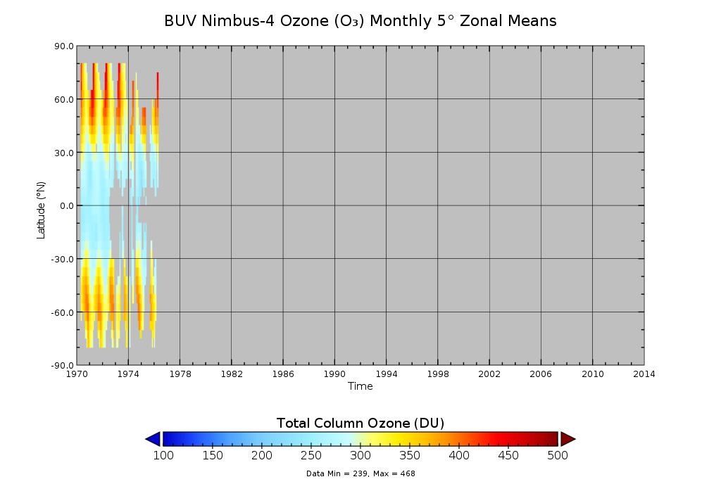
Federal
BUV/Nimbus-4 Ozone (O3) Profile and Total Column Ozone 1 Month Zonal Mean L3 Global 5.0 degree Latitude Zones V1 (BUVN04L3zm) at GES DISC
National Aeronautics and Space Administration —
The Solar Backscattered Ultraviolet (SBUV) from Nimbus-4 Level-3 monthly zonal mean (MZM) product (BUVN04L3zm) is derived from the Level-2 retrieved ozone profiles.... -
Federal
Global Distribution of Root Profiles in Terrestrial Ecosystems
National Aeronautics and Space Administration —
Rooting depths were estimated from a global database of root profiles that was assembled from the primary literature to study relationships of abiotic and biotic... -
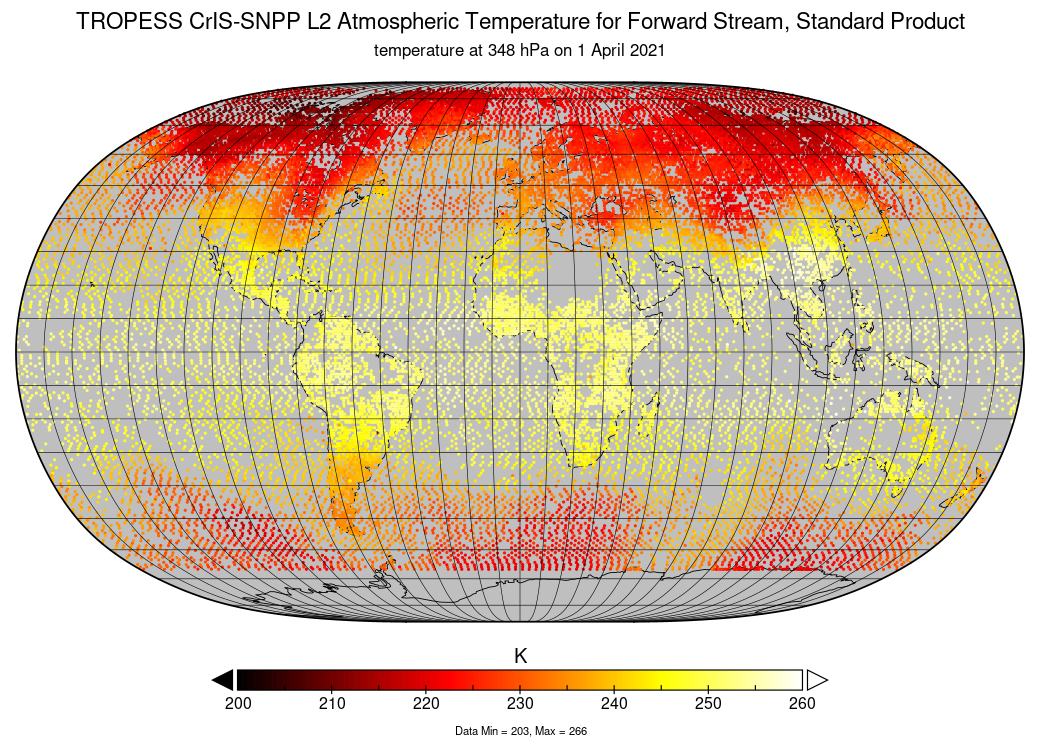
Federal
TROPESS CrIS-SNPP L2 Atmospheric Temperature for Forward Stream, Standard Product V1 (TRPSDL2TATMCRSFS) at GES DISC
National Aeronautics and Space Administration —
The TROPESS CrIS-SNPP L2 Atmospheric Temperature for Forward Stream, Standard Product contains the vertical distribution of the retrieved atmospheric state of... -
Federal
Bottom sediment chemical data at rivermouths and harbors along western Lake Michigan, USA, 2016
Department of the Interior —
Streambed sediment samples were collected in October 2016 from streams tributary to Wisconsin’s western Lake Michigan shoreline. Streams included two Areas of Concern... -
Federal
2MASS Calibration Merged Extended Source Information Table
National Aeronautics and Space Administration —
Photometric calibration for 2MASS was performed using observations of calibration fields made at regular intervals during each night of survey operations.... -
Federal
Environmental Data in Relation to the Occurrence and Toxicity of Pseudo nitzschia in Frenchman Bay, Maine, 2010 to 2021
Department of the Interior —
This dataset includes CSV data files containing environmental data that may be associated with the occurrence and toxicity of the diatom Pseudo nitzschia in Frenchman... -
Federal
Firehole River at Old Faithful, site number 06036805
Department of the Interior —
Sample and Specific Conductance Monitoring Site Near the USGS stream gage 06036805 (Latitude N 44°27'33.71", Longitude W 110°49'18.25", NAD83). Methods Specific... -
Federal
Sea Turtle Nesting Decision Points and Cross-Shore Beach Profile Data Collected on May 20, 2022, from South Hutchinson Beach, Florida
Department of the Interior —
On May 20, 2022, surveys were conducted on ‘high-density’ sea turtle nesting areas located on South Hutchinson Beach, Florida. This dataset,...
173 datasets found for "毕设ssm382航帆学院网站+vue毕业设计✅项目合作 二开均可 TG:saolei44✅.qCuGtRwRmYo"