
-
Federal
Discrete, profile measurements of the dissolved inorganic carbon (DIC), total alkalinity, pH on total scale and other hydrographic and chemical data obtained during the PS-94, ARK-XXIX/3, TransArc-II cruise onboard R/V Polarstern (EXPOCODE 06AQ20150817) in the central Arctic Ocean from 2015-08-17 to 2015-10-15 (NCEI Accession 0170256) recent views
National Oceanic and Atmospheric Administration, Department of Commerce —
The expedition PS94 Trans-Arctic survey of the Arctic Ocean in transition ("TransArc II") aimed at capturing the physical, biological, and chemical changes of the... -
Federal
Temperature, salinity, nutrient, and primary production collected by bottle and CTD in the North Atlantic Ocean from 8/25/1903 - 11/14/1997 (NCEI Accession 0000101) recent views
National Oceanic and Atmospheric Administration, Department of Commerce —
Temperature profile, algal species, and other data were collected using water bottle or CTD casts in the North Atlantic Ocean from WEST-HINDER and other platforms.... -
Federal
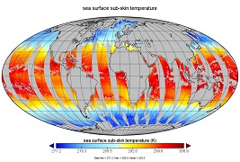
SST, Pathfinder Ver 5.2 (L3C), Day, Global, 0.0417°, 1981-2012, Science Quality (Monthly Composite) recent views
National Oceanic and Atmospheric Administration, Department of Commerce —
This dataset contains sea surface temperature (SST) data produced as part of the Advanced Very High Resolution Radiometer (AVHRR) Pathfinder SST Project, created... -
Federal
SST, NOAA Geo-Polar Blended Global Level 4, OSPO (Near Real Time, 2014-present), 0.05°, Nighttime recent views
National Oceanic and Atmospheric Administration, Department of Commerce —
Analysed blended sea surface temperature over the global ocean using night only input data. An SST estimation scheme which combines multi-satellite retrievals of sea... -
Federal
SEA LEVEL (TOPEX/POSEIDON) recent views
National Aeronautics and Space Administration —
Sea level rise is caused by the thermal expansion of sea water due to climate warming and widespread melting of land ice. The TOPEX/POSEIDON mission a joint satellite... -
Federal
SSMI(S) Hydrological Products recent views
National Oceanic and Atmospheric Administration, Department of Commerce —
The Special Sensor Microwave/Imager (SSM/I) and Special Sensor Microwave Imager-Sounder (SSMIS) have been making measurements of earth-emitted microwave radiation for... -
Federal
NOAA Climate Data Record (CDR) of AVHRR Polar Pathfinder Extended (APP-X) Cryosphere, Version 1 (Version Superseded) recent views
National Oceanic and Atmospheric Administration, Department of Commerce —
Note: This dataset version has been superseded by a newer version. It is highly recommended that users access the current version. Users should only use this version... -
Federal
SENTINEL-1B_SINGLE_POL_GRD_HIGH_RES recent views
National Aeronautics and Space Administration —
Sentinel-1B Single-pol ground projected high and full resolution images -
Federal
SASSIE Arctic Field Campaign Shipboard Salinity Snake Data Fall 2022 recent views
National Aeronautics and Space Administration —
The Salinity and Stratification at the Sea Ice Edge (SASSIE) project is a NASA experiment that aims to understand how salinity anomalies in the upper ocean generated... -
Federal
Seasonal Antarctic Sea Ice Extent Reconstructions, 1905-2020, Version 1 recent views
National Aeronautics and Space Administration —
These data are reconstructed seasonal Antarctic sea ice extent (SIE) for 1905 through 2020. They are provided along with uncertainty estimates and metadata that... -
Federal
GHRSST Level 3P North Atlantic Regional Subskin Sea Surface Temperature from the Advanced Very High Resolution Radiometer (AVHRR) on the MetOp-A satellite (GDS version 1) recent views
National Oceanic and Atmospheric Administration, Department of Commerce —
A Group for High Resolution Sea Surface Temperature (GHRSST) dataset for the North Atlantic Region (NAR) from the Advanced Very High Resolution Radiometer (AVHRR) on... -
Federal
SST, NOAA Geo-Polar Blended Global Level 4, STAR (Science Quality, 2002-2016), 0.05°, Nighttime, Lon0360 recent views
National Oceanic and Atmospheric Administration, Department of Commerce —
Analysed blended sea surface temperature over the global ocean. An SST estimation scheme which combines multi-satellite retrievals of sea surface temperature datasets... -
Federal
AMSR-E/Aqua Daily L3 25 km Brightness Temperature & Sea Ice Concentration Polar Grids V003 recent views
National Aeronautics and Space Administration —
This Level-3 gridded product (AE_SI25) includes brightness temperatures at 6.9 through 89.0 GHz and sea ice concentrations. -
Federal
SHEBA Reconnaissance Imagery, Version 1 recent views
National Aeronautics and Space Administration —
This data set consists of optical band reconnaissance imagery of the Surface Heat Balance of the Arctic (SHEBA) site acquired between August 1997 and October 1998.... -
Federal
AMSRIce03 Snow Ice Temperature Data, Version 1 recent views
National Aeronautics and Space Administration —
Notice to Data Users: The documentation for this data set was provided solely by the Principal Investigator(s) and was not further developed, thoroughly reviewed, or... -
Federal
Sea Ice Melt Pond Data from the Canadian Arctic, Version 1 recent views
National Aeronautics and Space Administration —
This data set contains observations of albedo, depth, and physical characteristics of melt ponds on sea ice, taken during the summer of 1994. The melt ponds studied... -
Federal
GHRSST Level 3U Global Near-Real-Time Subskin Sea Surface Temperature version 8a from the Advanced Microwave Scanning Radiometer 2 on the GCOM-W satellite recent views
National Aeronautics and Space Administration —
GDS2 Version -The Advanced Microwave Scanning Radiometer 2 (AMSR2) was launched on 18 May 2012, onboard the Golbal Change Observation Mission - Water (GCOM-W)... -
Federal
ECCO Sea-Ice and Snow Concentration and Thickness - Daily Mean 0.5 Degree (Version 4 Release 4) recent views
National Aeronautics and Space Administration —
This dataset contains daily-averaged sea-ice and snow concentration and thickness interpolated to a regular 0.5-degree grid from the ECCO Version 4 revision 4 (V4r4)... -
Federal
ECCO Sea-Ice and Snow Concentration and Thickness - Monthly Mean llc90 Grid (Version 4 Release 4) recent views
National Aeronautics and Space Administration —
This dataset provides monthly-averaged sea-ice and snow concentration, thickness, and pressure loading on the native Lat-Lon-Cap 90 (LLC90) model grid from the ECCO... -
Federal
NSCAT Gridded Level 3 Enhanced Resolution Sigma-0 from BYU recent views
National Aeronautics and Space Administration —
This NASA Scatterometer (NSCAT) satellite Sigma-0 dataset is generated by the Scatterometer Climate Record Pathfinder (SCP) project at Brigham Young University (BYU)...

Official websites use .gov
A
.gov website belongs to an official government
organization in the United States.
Secure .gov websites use HTTPS
A
lock (
) or https:// means you’ve safely connected to
the .gov website. Share sensitive information only on official,
secure websites.