
-
Federal
China Dimensions Data Collection: China Administrative Regions GIS Data: 1:1M, County Level, 1990
National Aeronautics and Space Administration —
The China Administrative Regions GIS Data: 1:1M, County Level, 1990 consists of geographic boundary data for the administrative regions of China as of 31 December... -
Federal
Latin America and the Caribbean Population Time Series
National Aeronautics and Space Administration —
The Latin America and the Caribbean Population Time Series data set provides total population estimates using spatially consistent and comparable Units for Latin... -
Federal
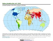
Gridded Population of the World, Version 4 (GPWv4): National Identifier Grid, Revision 11
National Aeronautics and Space Administration —
The Gridded Population of the World, Version 4 (GPWv4): National Identifier Grid, Revision 11 is a raster representation of nation-states in GPWv4 for use in... -
Federal
Global Flood Proportional Economic Loss Risk Deciles
National Aeronautics and Space Administration —
The Global Flood Proportional Economic Loss Risk Deciles is a 2.5 minute grid of flood hazard economic loss as proportions of Gross Domestic Product (GDP) per... -
Federal
Daily 8-Hour Maximum and Annual O3 Concentrations for the Contiguous United States, 1-km Grids, v1 (2000 - 2016)
National Aeronautics and Space Administration —
The Daily 8-Hour Maximum and Annual O3 Concentrations for the Contiguous United States, 1-km Grids, v1 (2000 - 2016) data set contains estimates of ozone... -
Federal
Global Volcano Hazard Frequency and Distribution
National Aeronautics and Space Administration —
Global Volcano Hazard Frequency and Distribution is a 2.5 minute gridded data set based upon the National Geophysical Data Center (NGDC) Volcano Database spanning the... -
Federal
U.S. Census Grids (Summary File 3), 2000: Metropolitan Statistical Areas
National Aeronautics and Space Administration —
The U.S. Census Grids (Summary File 3), 2000: Metropolitan Statistical Areas data set contains grids of demographic and socioeconomic data from the year 2000 U.S.... -
Federal
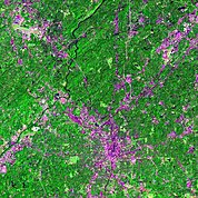
Urban Landsat: Cities from Space
National Aeronautics and Space Administration —
The Urban Landsat: Cities from Space data set contains images for 66 urban areas and the raw, underlying data for 28 of these places. Each image shows a Landsat false... -
Federal
Global Annual PM2.5 Grids from MODIS, MISR and SeaWiFS Aerosol Optical Depth (AOD), 1998-2019, V4.GL.03 NGDA
National Aeronautics and Space Administration —
The Global Annual PM2.5 Grids from MODIS, MISR and SeaWiFS Aerosol Optical Depth (AOD), 1998-2019, V4.GL.03 consists of annual concentrations (micrograms per cubic... -
Federal
Daily and Annual PM2.5, O3, and NO2 Concentrations at ZIP Codes for the Contiguous U.S., 2000-2016, v1.0
National Aeronautics and Space Administration —
The Daily and Annual PM2.5, O3, and NO2 Concentrations at ZIP Codes for the Contiguous U.S., 2000-2016, v1.0 data set contains daily and annual concentration... -
Federal
Low Elevation Coastal Zone (LECZ) Urban-Rural Population and Land Area Estimates, Version 2
National Aeronautics and Space Administration —
The Low Elevation Coastal Zone (LECZ) Urban-Rural Population and Land Area Estimates, Version 2 data set consists of country-level estimates of urban population,... -
Federal
Gridded Species Distribution: Global Amphibian Richness Grids, 2015 Release
National Aeronautics and Space Administration —
The 2015 Release of the Global Amphibian Richness Grids data set of the Gridded Species Distribution collection are aggregations of the presence grids data for the... -
Federal
Global Urban Polygons and Points Dataset (GUPPD), Version 1
National Aeronautics and Space Administration —
The Global Urban Polygons and Points Dataset (GUPPD), Version 1 is a global data set of 123,034 urban settlements with place names and population for the years... -
Federal
West Africa Coastal Vulnerability Mapping: Population Projections, 2030 and 2050
National Aeronautics and Space Administration —
The West Africa Coastal Vulnerability Mapping: Population Projections, 2030 and 2050 data set is based on an unreleased working version of the Gridded Population of... -
Federal
Groundswell Spatial Population and Migration Projections at One-Eighth Degree According to SSPs and RCPs, 2010-2050
National Aeronautics and Space Administration —
The Groundswell Spatial Population and Migration Projections at One-Eighth Degree According to SSPs and RCPs, 2010-2050, data set provides a baseline population... -
Federal
U.S. Census Grids (Summary File 3), 1990: Metropolitan Statistical Areas
National Aeronautics and Space Administration —
The U.S. Census Grids (Summary File 3), 1990: Metropolitan Statistical Areas data set contains grids of demographic and socioeconomic data from the year 1990 U.S.... -
Federal
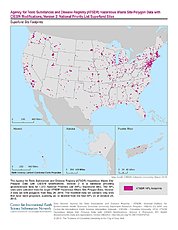
ATSDR Hazardous Waste Site Polygon Data with CIESIN Modifications, Version 2
National Aeronautics and Space Administration —
The Agency for Toxic Substances and Disease Registry (ATSDR) Hazardous Waste Site Polygon Data with CIESIN Modifications, Version 2 is a database providing... -
Federal
Global Multihazard Mortality Risks and Distribution
National Aeronautics and Space Administration —
The Global Multihazard Mortality Risks and Distribution is a 2.5 minute grid identifying and characterizing the nature of multihazard risk at the global scale. For...

Official websites use .gov
A
.gov website belongs to an official government
organization in the United States.
Secure .gov websites use HTTPS
A
lock (
) or https:// means you’ve safely connected to
the .gov website. Share sensitive information only on official,
secure websites.