
-
Federal
Global Monthly and Seasonal Urban and Land Backscatter Time Series, 1993-2020
National Aeronautics and Space Administration —
The Global Monthly and Seasonal Urban and Land Backscatter Time Series, 1993-2020, is a multi-sensor, multi-decadal, data set of global microwave backscatter, for... -
Federal
Global Grid of Probabilities of Urban Expansion to 2030
National Aeronautics and Space Administration —
The Global Grid of Probabilities of Urban Expansion to 2030 presents spatially explicit probabilistic forecasts of global urban land cover change from 2000 to 2030 at... -
Federal
China Dimensions Data Collection: Fundamental GIS: Digital Chart of China, 1:1M, Version 1
National Aeronautics and Space Administration —
The Fundamental GIS: Digital Chart of China, 1:1M, Version 1 consists of vector maps of China and surrounding areas. The maps include roads, railroads, drainage... -
Federal
Daily and Annual PM2.5 Concentrations for the Contiguous United States, 1-km Grids, v1 (2000 - 2016)
National Aeronautics and Space Administration —
The Daily and Annual PM2.5 Concentrations for the Contiguous United States, 1-km Grids, v1 (2000 - 2016) data set includes predictions of PM2.5 concentrations in grid... -
Federal
HANPP Collection: Human Appropriation of Net Primary Productivity (HANPP) by Country and Product
National Aeronautics and Space Administration —
The HANPP Collection: Human Appropriation of Net Primary Productivity (HANPP) by Country and Product contains tabular data on carbon-equivalents of consumption by... -
Federal
IPCC Fourth Assessment Report (AR4) Observed Climate Change Impacts Database
National Aeronautics and Space Administration —
The Intergovernmental Panel on Climate Change (IPCC) Fourth Assessment Report (AR4) Observed Climate Change Impacts Database contains observed responses to climate... -
Federal
CODATA Catalog of Roads Data Sets, Version 1
National Aeronautics and Space Administration —
The CODATA Catalog of Roads Data Sets, Version 1 contains 367 entries describing national-level road network data sets for 147 countries and four entries describing... -
Federal
Global Fire Emissions Indicators, Country-Level Tabular Data: 1997-2015
National Aeronautics and Space Administration —
The Global Fire Emissions Indicators, Country-Level Tabular Data: 1997-2015 contains country tabulations from 1997 to 2015 for the total area burned (hectares) and... -
Federal
Low Elevation Coastal Zone (LECZ) Urban-Rural Population and Land Area Estimates, Version 3
National Aeronautics and Space Administration —
The Low Elevation Coastal Zone (LECZ) Urban-Rural Population and Land Area Estimates, Version 3 data set contains land areas with urban, quasi-urban, rural, and total... -
Federal
Global Annual PM2.5 Grids from MODIS, MISR and SeaWiFS Aerosol Optical Depth (AOD), 1998-2019, V4.GL.03 NGDA
National Aeronautics and Space Administration —
The Global Annual PM2.5 Grids from MODIS, MISR and SeaWiFS Aerosol Optical Depth (AOD), 1998-2019, V4.GL.03 consists of annual concentrations (micrograms per cubic... -
Federal
Global Fertilizer and Manure, Version 1: Nitrogen in Manure Production
National Aeronautics and Space Administration —
The Nitrogen in Manure Production data set of the Global Fertilizer and Manure, Version 1 Data Collection represents the amount of nitrogen manure produced and... -
Federal
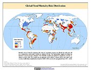
Global Flood Mortality Risks and Distribution
National Aeronautics and Space Administration —
The Global Flood Mortality Risks and Distribution is a 2.5 minute grid of global flood mortality risks. Gridded Population of the World, Version 3 (GPWv3) data... -
Federal
Last of the Wild Project, Version 2, 2005 (LWP-2): Global Human Influence Index (HII) Dataset (Geographic)
National Aeronautics and Space Administration —
The Global Human Influence Index Dataset of the Last of the Wild Project, Version 2, 2005 (LWP-2) is a global dataset of 1-kilometer grid cells, created from nine... -
Federal
Latin America and the Caribbean Population Time Series
National Aeronautics and Space Administration —
The Latin America and the Caribbean Population Time Series data set provides total population estimates using spatially consistent and comparable Units for Latin... -
Federal
China Dimensions Data Collection: China Maps Bibliographic Database
National Aeronautics and Space Administration —
The China Maps Bibliographic Database is an historical collection of bibliographic information for more than 400 maps of China. The information resides in a... -
Federal
Poverty Mapping Project: Global Subnational Prevalence of Child Malnutrition
National Aeronautics and Space Administration —
The Poverty Mapping Project: Global Subnational Prevalence of Child Malnutrition data set consists of estimates of the percentage of children with weight-for-age... -
Federal
Global 1-km Downscaled Urban Land Extent Projection and Base Year Grids by SSP Scenarios, 2000-2100
National Aeronautics and Space Administration —
The Global 1-km Downscaled Urban Land Extent Projection and Base Year Grids by SSP Scenarios, 2000-2100 consists of global SSP-consistent spatial urban land fraction... -
Federal
Gridded Population of the World, Version 3 (GPWv3): National Administrative Boundaries
National Aeronautics and Space Administration —
The Gridded Population of the World, Version 3 (GPWv3): National Administrative Boundaries are derived from the land area grid to show the outlines of pixels (cells)... -
Federal
Global Gridded Relative Deprivation Index (GRDI), Version 1
National Aeronautics and Space Administration —
The Global Gridded Relative Deprivation Index (GRDI), Version 1 (GRDIv1) data set characterizes the relative levels of multidimensional deprivation and poverty in...

Official websites use .gov
A
.gov website belongs to an official government
organization in the United States.
Secure .gov websites use HTTPS
A
lock (
) or https:// means you’ve safely connected to
the .gov website. Share sensitive information only on official,
secure websites.