
-
Federal
Daymet: Station-Level Inputs and Cross-Validation for North America, Version 4 R1
National Aeronautics and Space Administration —
This dataset reports the station-level daily weather observation data and the corresponding cross-validation results for three Daymet model parameters: minimum... -
Federal
CARVE: L1 Spectral Radiances from Airborne FTS, Alaska, 2012-2015
National Aeronautics and Space Administration —
This data set contains Level 1 spectral radiance data collected using the Fourier Transform Spectrometer (FTS) during airborne campaigns over the Alaskan and Canadian... -
Federal
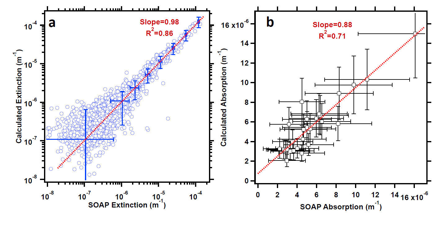
ATom: Aerosol Extinction and Absorption Measurements from SOAP Instrument, 2018
National Aeronautics and Space Administration —
This dataset contains one-second aerosol extinction and absorption measurements from the Spectrometers for Optical Aerosol Properties (SOAP) instrument aboard the... -
Federal
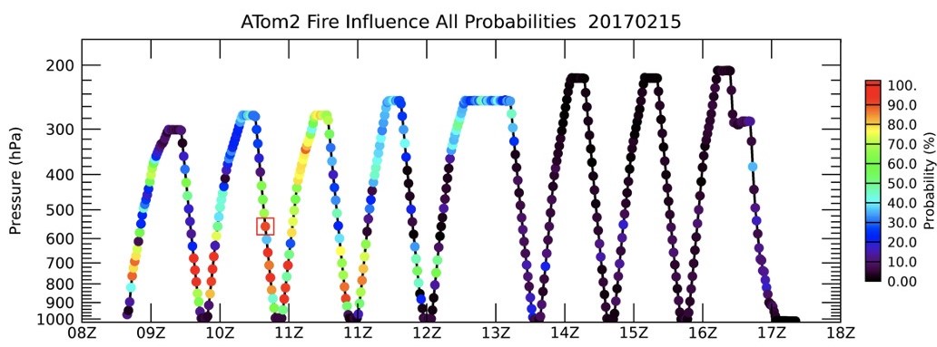
ATom: Back Trajectories and Influences of Air Parcels Along Flight Track, 2016-2018
National Aeronautics and Space Administration —
This dataset contains back trajectories, boundary layer influences, and convective influences of air parcels along NASA DC-8 aircraft's flight tracks during the four... -
Federal
BOREAS HYD-02 Estimated Snow Water Equivalent (SWE) from Microwave Measurements
National Aeronautics and Space Administration —
The surface meteorological data collected at the BOREAS tower and ancillary sites are being used as inputs to an energy balance model to monitor the amount of snow... -
Federal
Biome-BGC: Modeling Carbon Dynamics in Ponderosa Pine Stands (Law et al. 2003)
National Aeronautics and Space Administration —
This archived model product contains the directions, executables, and procedures for running Biome-BGC, Version 4.1.2, to recreate the results of Law BE, Sun OJ,... -
Federal
A Global Database of Soil Phosphorus Compiled from Studies Using Hedley Fractionation
National Aeronautics and Space Administration —
This data set provides concentrations of soil phosphorus (P) compiled from the peer-reviewed literature that cited the Hedley fractionation method (Hedley and... -
Federal
ABoVE: Light-Curve Modelling of Gridded GPP Using MODIS MAIAC and Flux Tower Data
National Aeronautics and Space Administration —
This dataset contains gridded estimations of daily ecosystem Gross Primary Production (GPP) in grams of carbon per day at a 1 km2 spatial resolution over Alaska and... -
Federal
ACT-America: L2 In Situ Atmospheric CO2, CO, CH4, and O3 Concentrations, Eastern USA
National Aeronautics and Space Administration —
This dataset provides atmospheric carbon dioxide (CO2), carbon monoxide (CO), methane (CH4), water vapor (H2O), and ozone (O3) concentrations collected during... -
Federal
30 Minute Rainfall Data (FIFE)
National Aeronautics and Space Administration —
The FIFE Thirty Minute Rainfall Data Data Set contains data from thirty rain gauges located in the Kings Creek basin in the northwest corner of the FIFE study area... -
Federal
Delta-X: Soil Properties for Herbaceous Wetlands, MRD, Louisiana, 2021, V3
National Aeronautics and Space Administration —
This dataset contains properties of soil core samples for herbaceous wetlands collected in the Atchafalaya and Terrebonne basins in southeastern coastal Louisiana for... -
Federal
BOREAS TGB-06 Soil Methane Oxidation and Production from NSA BP and Fen Sites
National Aeronautics and Space Administration —
The BOREAS TGB-06 team collected soil methane measurements at several sites in the SSA and NSA. This data set contains soil methane consumption (bacterial CH4... -
Federal
BOREAS NS001 TMS Level-2 Images: Reflectance and Temperature in BSQ Format
National Aeronautics and Space Administration —
For BOREAS, the NS001 TMS images, along with the other remotely sensed data, were collected to provide spatially extensive information over the primary study areas.... -
Federal
BOREAS Follow-On FLX-04 Tower Flux and Meteorological Data from NSA Burn Site
National Aeronautics and Space Administration —
Tower flux and meteorological data were collected above 4 black spruce forest sites in the NSA that experienced stand-replacing wildfires in 1989,1981,1964 and 1930.... -
Federal
ATom: L2 Trace Gas and Isotope Measurements from Medusa Whole Air Sampler, Version 2
National Aeronautics and Space Administration —
This dataset provides O2/N2, CO2, Ar/N2, and stable isotope ratios of CO2 measured in flasks collected by the Medusa Whole Air Sampler during airborne campaigns... -
Federal
AVIRIS Facility Instruments: Flight Line Geospatial and Contextual Data
National Aeronautics and Space Administration —
This dataset provides attributed geospatial and tabular information for identifying and querying flight lines of interest for the Airborne Visible InfraRed Imaging... -
Federal
BOREAS TGB-01 CH4 Concentration and Flux Data from NSA Tower Sites
National Aeronautics and Space Administration —
The BOREAS TGB-01 team made numerous measurements of trace gas concentrations and fluxes at various NSA sites. This data set contains half-hourly averages of ambient... -
Federal
BOREAS/SRC AMS Suite A Surface Meteorological and Radiation Data: 1995
National Aeronautics and Space Administration —
The Saskatchewan Research Council (SRC) collected surface meteorological and radiation data from December, 1993 until Decemb er 1996. The data set is comprised of the... -
Federal
BOREAS HYD-03 Snow Temperature Profiles
National Aeronautics and Space Administration —
The BOREAS HYD-03 team collected several data sets related to the hydrology of forested areas. This data set contains measurements of snow depth, snow density in 3-cm...

Official websites use .gov
A
.gov website belongs to an official government
organization in the United States.
Secure .gov websites use HTTPS
A
lock (
) or https:// means you’ve safely connected to
the .gov website. Share sensitive information only on official,
secure websites.