
-
Federal
BOREAS HYD-03 Canopy Density Data
National Aeronautics and Space Administration —
The BOREAS HYD-03 team collected several data sets related to the hydrology of forested areas. This data set contains measurements of canopy density (closure) from a... -
Federal
BOREAS RSS-12 Airborne Tracking Sunphotometer Measurements (C-130)
National Aeronautics and Space Administration —
The BOREAS RSS-12 team collected both ground and airborne sunphotometer measurements for use in characterizing the aerosol optical properties of the atmosphere during... -
Federal
BOREAS TE-12 Leaf Optical Data for SSA Species
National Aeronautics and Space Administration —
The BOREAS TE-12 team collected several data sets in support of its efforts to characterize and interpret information on the reflectance, transmittance, and gas... -
Federal
NPP Tropical Forest: Gunung Mulu, Malaysia, 1977-1978, R1
National Aeronautics and Space Administration —
This data set contains seven ASCII data files (.txt format). Four files provide NPP data for contrasting lowland rainforests within Gunung Mulu National Park on the... -
Federal
Aircraft Flux-Detrended: Univ. Col. (FIFE)
National Aeronautics and Space Administration —
The NCAR King Air participation in FIFE-1987 and FIFE-1989 was part of a coordinated atmospheric boundary layer component which included other aircraft, surface... -
Federal
Global 1-km Gridded Thickness of Soil, Regolith, and Sedimentary Deposit Layers
National Aeronautics and Space Administration —
This data set provides high-resolution estimates of the thickness of the permeable layers above bedrock (soil, regolith, and sedimentary deposits) within a global... -
Federal
ATom: In Situ Atmospheric Water Vapor from the Diode Laser Hygrometer, Version 2
National Aeronautics and Space Administration —
This dataset provides the concentrations of water measured by the Diode Laser Hygrometer (DLH) flown on the NASA DC-8 during the ATom 1-4 campaigns from 2016 - 2018.... -
Federal
Global Data Set of Derived Soil Properties, 0.5-Degree Grid (ISRIC-WISE)
National Aeronautics and Space Administration —
The World Inventory of Soil Emission Potentials (WISE) database currently contains data for over 4300 soil profiles collected mostly between 1950 and 1995. This... -
Federal
AVIRIS-3 L2A Orthocorrected Surface Reflectance, Facility Instrument Collection
National Aeronautics and Space Administration —
This dataset contains Level 2A (L2A) surface reflectance images from the Airborne Visible / Infrared Imaging Spectrometer-3 (AVIRIS-3) instrument. This is the NASA... -
Federal
MASTER: Geological Earth Mapping Experiment (GEMx), Spring 2024
National Aeronautics and Space Administration —
This dataset includes Level 1B (L1B) data products from the MODIS/ASTER Airborne Simulator (MASTER) instrument. The spectral data were collected during 26 flights... -
Federal
NPP Cropland: Gridded Estimates For the Central USA, 1982-1996, R1
National Aeronautics and Space Administration —
This data set contains a single data file (.csv format) that provides gridded values of net primary productivity (NPP) for cropland in eight counties in the central... -
Federal
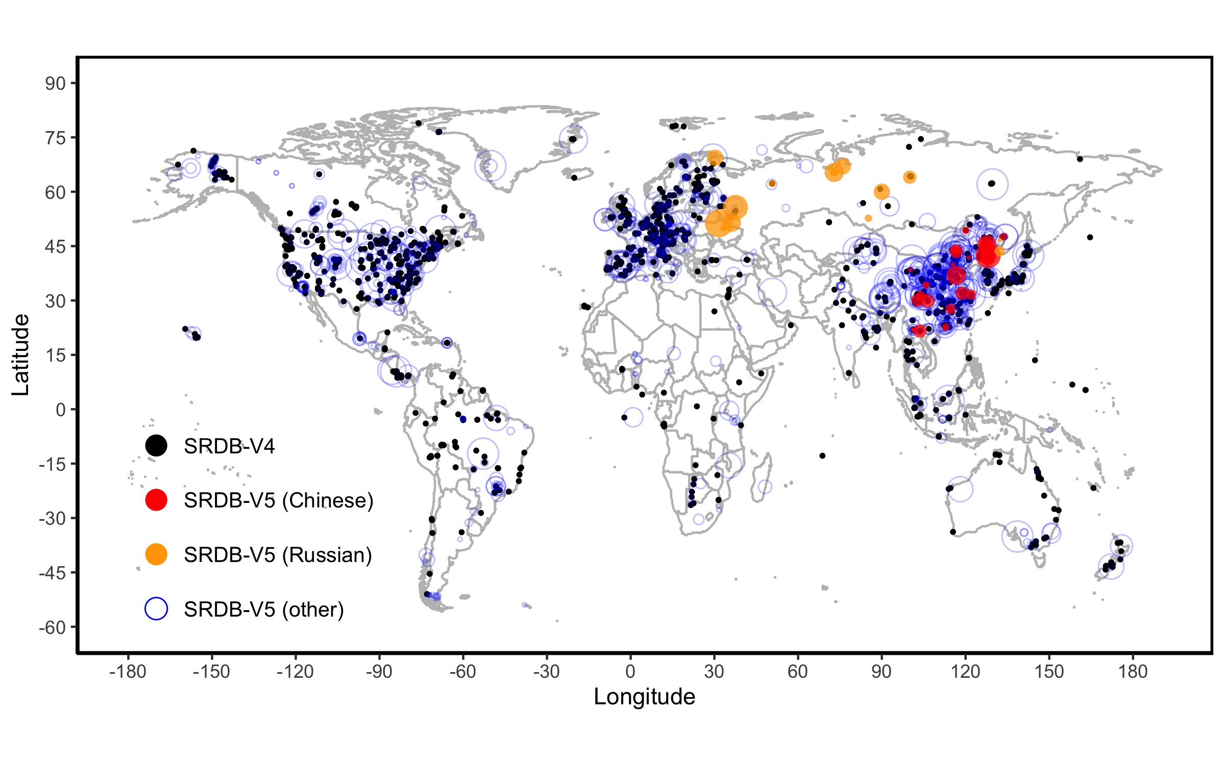
A Global Database of Soil Respiration Data, Version 5.0
National Aeronautics and Space Administration —
The Soil Respiration Database (SRDB) is a near-universal compendium of published soil respiration (Rs) data. The database encompasses published studies that report at... -
Federal
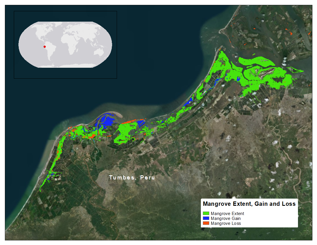
CMS: Mangrove Forest Cover Extent and Change across Major River Deltas, 2000-2016
National Aeronautics and Space Administration —
This dataset provides estimates of mangrove extent for 2016, and mangrove change (gain or loss) from 2000 to 2016, in major river delta regions of eight countries:... -
Federal
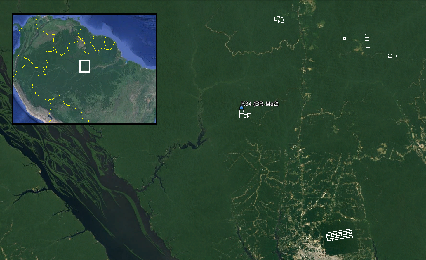
LiDAR and DTM Data from Forested Land Near Manaus, Amazonas, Brazil, 2008
National Aeronautics and Space Administration —
This data set provides LiDAR point clouds and digital terrain models (DTM) from surveys over the K34 tower site in the Cuieiras Biological Reserve, over forest... -
Federal
LBA Regional Land Cover from AVHRR, 8-km, 1984 (DeFries et al.)
National Aeronautics and Space Administration —
This data set is a subset of an 8-km global land cover product (DeFries et al. 1998). This subset was created for the study area of the Large Scale Biosphere-... -
Federal
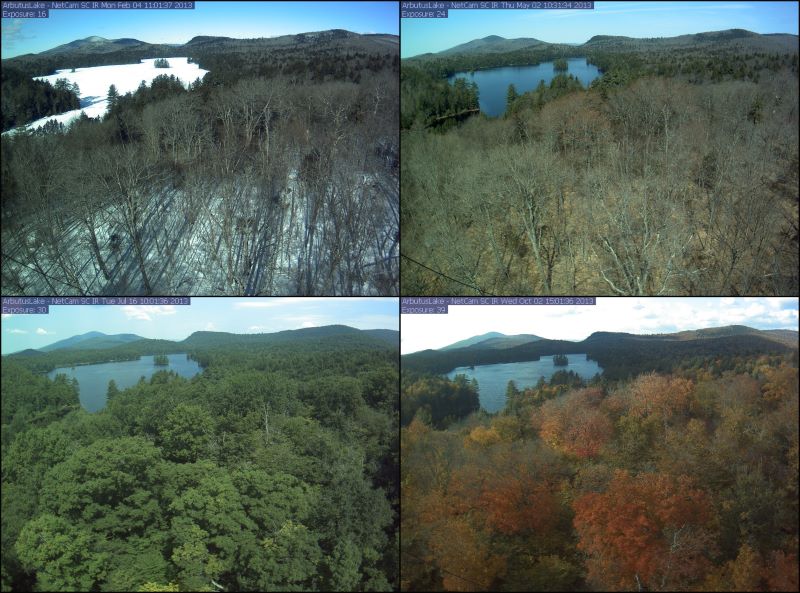
PhenoCam Dataset v3.0: Digital Camera Imagery from the PhenoCam Network, 2000-2023
National Aeronautics and Space Administration —
This dataset provides a time series of visible-wavelength digital camera imagery collected through the PhenoCam Network at each of 738 sites across diverse ecosystems... -
Federal
ISLSCP II EDGAR 3 Gridded Greenhouse and Ozone Precursor Gas Emissions
National Aeronautics and Space Administration —
The EDGAR (Emission Database for Global Atmospheric Research) database project is a comprehensive task carried out jointly by the National Institute for Public Health... -
Federal
LBA-ECO CD-06 Physical, Political, and Hydrologic Maps, Ji-Parana River Basin, Brazil
National Aeronautics and Space Administration —
This data set contains physical, hydrologic, political, demographic, and societal maps for the Ji-Parana River Basin, in the state of Rondonia, Brazil. These data... -
Federal
CARVE: Fire-Related Aerosol and Soil Elemental and Isotopic Composition, Alaska, 2013
National Aeronautics and Space Administration —
This data set provides measurements of the isotopic composition of black carbon and organic carbon aerosols collected at two locations in interior Alaska during the...

Official websites use .gov
A
.gov website belongs to an official government
organization in the United States.
Secure .gov websites use HTTPS
A
lock (
) or https:// means you’ve safely connected to
the .gov website. Share sensitive information only on official,
secure websites.